Property Record
222608 E Game Farm Rd, Kennewick, WA 99337
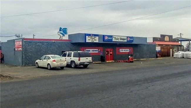
This Property Is For Sale
NEARBY LISTINGS FOR SALE OR LEASE
-
-
View all Kennewick listings for sale on LoopNet.com
Property Detail
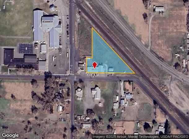
222608 E Game Farm Rd
Kennewick-Richland, WA
THE PORTION OF SECTION 23, TOWNSHIP 8, RANGE 30 DEFINED AS FOLLOWS: THE PORTION OF THE SOUTHWEST OF THE SOUTHWEST OF THE SOUTHWEST LYING SOUTHWESTERLY OF THE S.P.&S. RAILROAD RIGHT OF WAY DEFINED AS FOLLOWS: BEGINNING AT A POINT 20.00 FEET NORTH AND
123803000006001
Benton
Supermarket
Washington
2024
2.33 AC
2024
Yakima/Kennewick
011501
Other Market Areas
7,400 SF
DEMOGRAPHICS near 222608 E Game Farm Rd
1 Mile
3 Mile
5 Mile
2024 Total Population
1,621
6,906
21,643
2029 Population
1,733
7,348
22,909
Pop Growth 2024-2029
+ 6.91%
+ 6.40%
+ 5.85%
Average Age
40
39
38
2024 Total Households
525
2,294
7,167
HH Growth 2024-2029
+ 6.86%
+ 6.45%
+ 5.85%
Median Household Inc
$73,499
$76,218
$75,403
Avg Household Size
2.90
2.90
2.90
2024 Avg HH Vehicles
3.00
3.00
3.00
Median Home Value
$358,546
$345,937
$322,332
Median Year Built
1977
1984
1978
Nearby Places
- Restaurants
- Banks
- Shops
- Fitness
- Groceries
PUBLIC TRANSPORTATION
COMMUTER RAIL
Pasco Amtrak Station (Empire Builder - Amtrak)
DRIVE
WALK
Distance
Pasco Amtrak Station (Empire Builder - Amtrak)
14 min
8.1 mi
AIRPORT
Tri-Cities
DRIVE
WALK
Distance
Tri-Cities
19 min
10.1 mi
Freight Ports
Port of Tacoma
DRIVE
WALK
Distance
Port of Tacoma
283 min
243.5 mi
Nearby Properties
Address
Land Use
TOTAL SIZE
Lot Size
Zoning
Address
Land Use
TOTAL SIZE
Lot Size
Zoning
22.76 AC
BENTON COU
Address
Land Use
TOTAL SIZE
Lot Size
Zoning
167,630 SF
32.77 AC
Address
Land Use
TOTAL SIZE
Lot Size
Zoning
77,612 SF
20.18 AC
BENTON COU
Address
Land Use
TOTAL SIZE
Lot Size
Zoning
26,630 SF
17.49 AC
BENTON COU
Address
Land Use
TOTAL SIZE
Lot Size
Zoning
10.75 AC
BENTON COU
Address
Land Use
TOTAL SIZE
Lot Size
Zoning
32,649 SF
Address
Land Use
TOTAL SIZE
Lot Size
Zoning
54.71 AC
Address
Land Use
TOTAL SIZE
Lot Size
Zoning
13,822 SF
71.23 AC
Address
Land Use
TOTAL SIZE
Lot Size
Zoning
4,800 SF
6.43 AC
Address
Land Use
TOTAL SIZE
Lot Size
Zoning
1,512 SF
166.67 AC
Address
Land Use
TOTAL SIZE
Lot Size
Zoning
4,288 SF
156.90 AC
G.M.A. AGR
Address
Land Use
TOTAL SIZE
Lot Size
Zoning
11,232 SF
36.80 AC
G.M.A. AGR
Address
Land Use
TOTAL SIZE
Lot Size
Zoning
13,511 SF
5.63 AC
BENTON COU
Address
Land Use
TOTAL SIZE
Lot Size
Zoning
17,792 SF
3.50 AC
Address
Land Use
TOTAL SIZE
Lot Size
Zoning
1,666 SF
80.32 AC
Address
Land Use
TOTAL SIZE
Lot Size
Zoning
3,696 SF
40 AC
Address
Land Use
TOTAL SIZE
Lot Size
Zoning
1,082 SF
369.01 AC
G.M.A. AGR
Address
Land Use
TOTAL SIZE
Lot Size
Zoning
2,828 SF
46.16 AC
Address
Land Use
TOTAL SIZE
Lot Size
Zoning
8,139 SF
20.22 AC
Address
Land Use
TOTAL SIZE
Lot Size
Zoning
1,728 SF
82.47 AC
Address
Land Use
TOTAL SIZE
Lot Size
Zoning
5,278 SF
3.66 AC
Address
Land Use
TOTAL SIZE
Lot Size
Zoning
80.95 AC
Address
Land Use
TOTAL SIZE
Lot Size
Zoning
2,982 SF
88.30 AC
RURAL LAND
Address
Land Use
TOTAL SIZE
Lot Size
Zoning
17,213 SF
3.07 AC
BENTON COU
Address
Land Use
TOTAL SIZE
Lot Size
Zoning
2,720 SF
62.58 AC
Address
Land Use
TOTAL SIZE
Lot Size
Zoning
1,062 SF
79.75 AC
Address
Land Use
TOTAL SIZE
Lot Size
Zoning
4,338 SF
53.52 AC
Address
Land Use
TOTAL SIZE
Lot Size
Zoning
3,094 SF
19.40 AC
Address
Land Use
TOTAL SIZE
Lot Size
Zoning
3,321 SF
25.57 AC
Address
Land Use
TOTAL SIZE
Lot Size
Zoning
14,040 SF
4 AC
BENTON COU
The World's #1 Commercial Real Estate Marketplace
Connect with us
© 2025 CoStar Group
The information above has been obtained from sources believed reliable. While we do not doubt its accuracy we have not verified it and make no guarantee, warranty or representation about it. It is your responsibility to independently confirm its accuracy and completeness. Any projections, opinions, assumptions, or estimates used are for example only and do not represent the current or future performance of the property. The value of this transaction to you depends on tax and other factors which should be evaluated by your tax, financial, and legal advisors. You and your advisors should conduct a careful, independent investigation of the property to determine to your satisfaction the suitability of the property for your needs.