Property Record
22261 Libby Rd, Bedford, OH 44146
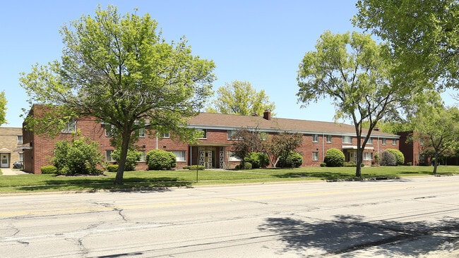

Property Detail
22261 Libby Rd
Cleveland-Elyria, OH
7 LIBBYGDNS 0001 ALL
791-19-048
CUYAHOGA
Apartment
Ohio
R-3
1
AE The base floodplain where base flood elevations are provided. AE Zones are now used on new format FIRMs instead of A1-A30 Zones.
1.81 AC
2025
Bedford Heights
2025
Cleveland
133103
NEARBY LISTINGS FOR SALE OR LEASE
-
-
View all Bedford listings for sale on LoopNet.com
DEMOGRAPHICS near 22261 Libby Rd
1 mile
3 mile
5 mile
2025 Total Population
9,007
71,473
177,347
2030 Population
9,023
71,343
176,036
Pop Growth 2025-2030
+ 0.18%
(0.18%)
(0.74%)
Average Age
41
42
42
2025 Total Households
4,040
32,271
76,029
HH Growth 2025-2030
(0.05%)
(0.34%)
(0.85%)
Median Household Inc
$51,560
$53,641
$60,748
Avg Household Size
2.20
2.10
2.30
2025 Avg HH Vehicles
1.00
1.00
2.00
Median Home Value
$126,850
$126,528
$158,587
Median Year Built
1958
1958
1955
Nearby Places
Map Layers
Map Styles
 Street
 Aerial
Layers
 Traffic
 Biking
Places
Listings with unknown addresses are not visible on the map
- Restaurants
- Banks
- Shops
- Fitness
- Groceries
PUBLIC TRANSPORTATION
COMMUTER RAIL
Canal Exploration Center (National Park Scenic Railway - Cuyahoga Valley Scenic Railroad)
Drive
Walk
Distance
Canal Exploration Center (National Park Scenic Railway - Cuyahoga Valley Scenic Railroad)
16 min
7.1 mi
Rockside (National Park Scenic Railway - Cuyahoga Valley Scenic Railroad)
Drive
Walk
Distance
Rockside (National Park Scenic Railway - Cuyahoga Valley Scenic Railroad)
15 min
7.5 mi
AIRPORT
Cleveland-Hopkins International
Drive
Walk
Distance
Cleveland-Hopkins International
30 min
19.0 mi
Freight Ports
Port of Toledo
Drive
Walk
Distance
Port of Toledo
144 min
119.9 mi
SALE & LEASE HISTORY
LISTING DATE
SALE/LEASE

Sep 23, 2016
For Sale
Nearby Properties
Address
Land Use
TOTAL SIZE
Lot Size
Zoning
Address
Land Use
TOTAL SIZE
Lot Size
Zoning
975,742 SF
42.03 AC
U-10
Address
Land Use
TOTAL SIZE
Lot Size
Zoning
682,144 SF
99.58 AC
C-2
Address
Land Use
TOTAL SIZE
Lot Size
Zoning
68.97 AC
C-1
Address
Land Use
TOTAL SIZE
Lot Size
Zoning
323,733 SF
106.35 AC
MRC2
Address
Land Use
TOTAL SIZE
Lot Size
Zoning
233,767 SF
36.30 AC
U-1A1
Address
Land Use
TOTAL SIZE
Lot Size
Zoning
333,582 SF
3.67 AC
U-1A1
Address
Land Use
TOTAL SIZE
Lot Size
Zoning
360,712 SF
55.30 AC
INS
Address
Land Use
TOTAL SIZE
Lot Size
Zoning
289,009 SF
25.27 AC
I/O
Address
Land Use
TOTAL SIZE
Lot Size
Zoning
232,078 SF
24.89 AC
U-7
Address
Land Use
TOTAL SIZE
Lot Size
Zoning
204,701 SF
10.12 AC
Address
Land Use
TOTAL SIZE
Lot Size
Zoning
92,058 SF
31.37 AC
INS
Address
Land Use
TOTAL SIZE
Lot Size
Zoning
143,512 SF
16 AC
Address
Land Use
TOTAL SIZE
Lot Size
Zoning
11,808 SF
900.50 AC
1F-2
Address
Land Use
TOTAL SIZE
Lot Size
Zoning
99,919 SF
17.91 AC
U-1A1
Address
Land Use
TOTAL SIZE
Lot Size
Zoning
235,921 SF
12.45 AC
SC
Address
Land Use
TOTAL SIZE
Lot Size
Zoning
18.38 AC
R2
Address
Land Use
TOTAL SIZE
Lot Size
Zoning
196,429 SF
10.31 AC
U-7
Address
Land Use
TOTAL SIZE
Lot Size
Zoning
120,722 SF
20.55 AC
I/O
Address
Land Use
TOTAL SIZE
Lot Size
Zoning
14.95 AC
I-1
Address
Land Use
TOTAL SIZE
Lot Size
Zoning
838,521 SF
5.70 AC
I
Address
Land Use
TOTAL SIZE
Lot Size
Zoning
105,215 SF
5.42 AC
PF
Address
Land Use
TOTAL SIZE
Lot Size
Zoning
137,795 SF
37.09 AC
R-4
Address
Land Use
TOTAL SIZE
Lot Size
Zoning
147,635 SF
15.14 AC
I-2
Address
Land Use
TOTAL SIZE
Lot Size
Zoning
324,644 SF
15.13 AC
I
Address
Land Use
TOTAL SIZE
Lot Size
Zoning
594,909 SF
39.82 AC
I-2
Address
Land Use
TOTAL SIZE
Lot Size
Zoning
347,218 SF
0.23 AC
O/I
Address
Land Use
TOTAL SIZE
Lot Size
Zoning
115,932 SF
14.15 AC
U-10
Address
Land Use
TOTAL SIZE
Lot Size
Zoning
65,108 SF
24.93 AC
I/O
Address
Land Use
TOTAL SIZE
Lot Size
Zoning
69,033 SF
8.85 AC
R-3
Address
Land Use
TOTAL SIZE
Lot Size
Zoning
164,109 SF
8.89 AC
U-1A1
The World's #1 Commercial Real Estate Marketplace
Connect with us
© 2026 CoStar Group
The information above has been obtained from sources believed reliable. While we do not doubt its accuracy we have not verified it and make no guarantee, warranty or representation about it. It is your responsibility to independently confirm its accuracy and completeness. Any projections, opinions, assumptions, or estimates used are for example only and do not represent the current or future performance of the property. The value of this transaction to you depends on tax and other factors which should be evaluated by your tax, financial, and legal advisors. You and your advisors should conduct a careful, independent investigation of the property to determine to your satisfaction the suitability of the property for your needs.