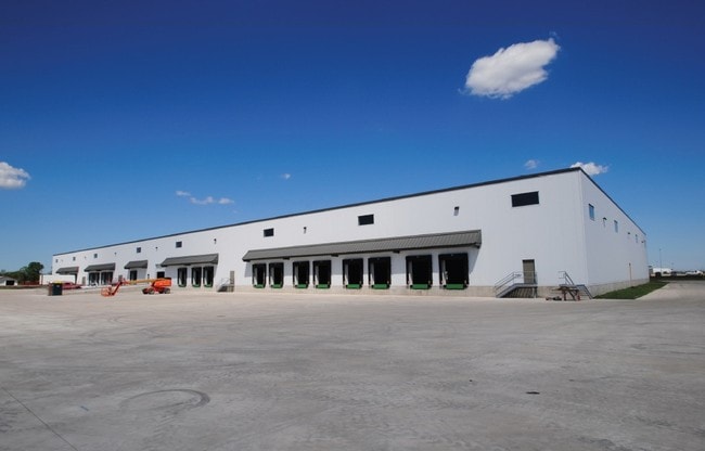
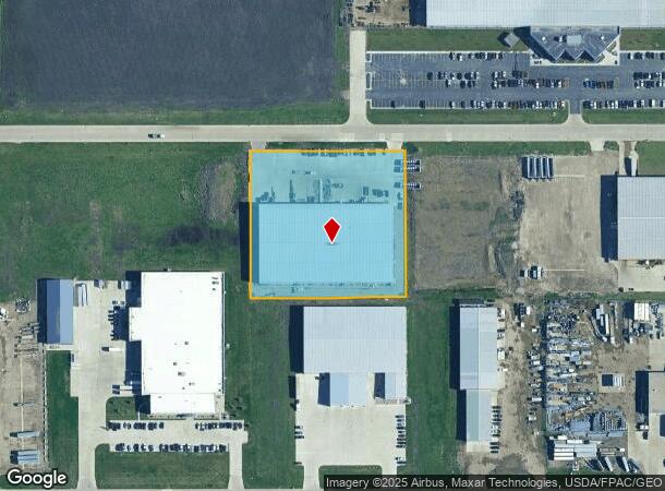
Property Record
2227 3Rd Ave Nw, West Fargo, ND 58078
NEARBY LISTINGS FOR SALE OR LEASE
-
-
No Photo
-
View all West Fargo listings for lease on LoopNet.com
Property Detail
2227 3Rd Ave Nw
Fargo, ND-MN
Butler Elebenth Addition
02-3905-00010-000
LOT: 1 BLOCK: 1 ADDITION: BUTLERS 11TH ADDITION ADDITIONAL: BUTLER'S 11TH ADDN LT 1 BLK 1 **9-13-17 REPLAT FRM 02-3902-00040-000, 00050-000, 00060-000 PER PLAT DOC#1491124 FOR 2017
Realpropertynec
Cass
X
North Dakota
38017C0565G
1
2024
3.15 AC
2024
Fargo
010201
Other Market Areas
62,700 SF
DEMOGRAPHICS near 2227 3Rd Ave Nw
1 Mile
3 Mile
5 Mile
2024 Total Population
97
16,641
58,636
2029 Population
104
17,857
63,029
Pop Growth 2024-2029
+ 7.22%
+ 7.31%
+ 7.49%
Average Age
36
39
35
2024 Total Households
38
6,902
25,153
HH Growth 2024-2029
+ 7.89%
+ 7.74%
+ 7.96%
Median Household Inc
$72,856
$76,157
$72,073
Avg Household Size
2.50
2.40
2.30
2024 Avg HH Vehicles
2.00
2.00
2.00
Median Home Value
$259,090
$243,038
$267,735
Median Year Built
1995
1991
2003
Nearby Places
Map Layers
Map Styles
 Street
 Aerial
- Restaurants
- Banks
- Shops
- Fitness
- Groceries
PUBLIC TRANSPORTATION
COMMUTER RAIL
Fargo Amtrak Station (Empire Builder - Amtrak)
DRIVE
WALK
Distance
Fargo Amtrak Station (Empire Builder - Amtrak)
16 min
8.3 mi
AIRPORT
Hector International
DRIVE
WALK
Distance
Hector International
20 min
10.7 mi
Freight Ports
Port Milwaukee
DRIVE
WALK
Distance
Port Milwaukee
638 min
580.4 mi
SALE & LEASE HISTORY
LISTING DATE
SALE/LEASE

May 22, 2018
For Lease
Nearby Properties
Address
Land Use
TOTAL SIZE
Lot Size
Zoning
Address
Land Use
TOTAL SIZE
Lot Size
Zoning
49.50 AC
Address
Land Use
TOTAL SIZE
Lot Size
Zoning
15,895 SF
41.76 AC
Address
Land Use
TOTAL SIZE
Lot Size
Zoning
99,300 SF
12.72 AC
Address
Land Use
TOTAL SIZE
Lot Size
Zoning
207,189 SF
23.72 AC
Address
Land Use
TOTAL SIZE
Lot Size
Zoning
79,310 SF
17.79 AC
Address
Land Use
TOTAL SIZE
Lot Size
Zoning
354,677 SF
13.13 AC
Address
Land Use
TOTAL SIZE
Lot Size
Zoning
156,450 SF
14.92 AC
Address
Land Use
TOTAL SIZE
Lot Size
Zoning
240,766 SF
15.14 AC
Address
Land Use
TOTAL SIZE
Lot Size
Zoning
131,360 SF
4.52 AC
Address
Land Use
TOTAL SIZE
Lot Size
Zoning
Address
Land Use
TOTAL SIZE
Lot Size
Zoning
180,000 SF
10.73 AC
Address
Land Use
TOTAL SIZE
Lot Size
Zoning
207,189 SF
22.99 AC
Address
Land Use
TOTAL SIZE
Lot Size
Zoning
13,970 SF
32.10 AC
Address
Land Use
TOTAL SIZE
Lot Size
Zoning
76,743 SF
5.69 AC
Address
Land Use
TOTAL SIZE
Lot Size
Zoning
16.39 AC
Address
Land Use
TOTAL SIZE
Lot Size
Zoning
193,114 SF
9.96 AC
Address
Land Use
TOTAL SIZE
Lot Size
Zoning
70,800 SF
9.18 AC
Address
Land Use
TOTAL SIZE
Lot Size
Zoning
60,947 SF
4.48 AC
Address
Land Use
TOTAL SIZE
Lot Size
Zoning
Address
Land Use
TOTAL SIZE
Lot Size
Zoning
102,000 SF
4.96 AC
Address
Land Use
TOTAL SIZE
Lot Size
Zoning
60,320 SF
1.15 AC
Address
Land Use
TOTAL SIZE
Lot Size
Zoning
28,107 SF
6.19 AC
Address
Land Use
TOTAL SIZE
Lot Size
Zoning
23,900 SF
19.41 AC
Address
Land Use
TOTAL SIZE
Lot Size
Zoning
8,256 SF
9.09 AC
Address
Land Use
TOTAL SIZE
Lot Size
Zoning
Address
Land Use
TOTAL SIZE
Lot Size
Zoning
50,400 SF
10.74 AC
Address
Land Use
TOTAL SIZE
Lot Size
Zoning
17.40 AC
Address
Land Use
TOTAL SIZE
Lot Size
Zoning
Address
Land Use
TOTAL SIZE
Lot Size
Zoning
5,940 SF
10.41 AC
Address
Land Use
TOTAL SIZE
Lot Size
Zoning
27,163 SF
9.30 AC
The World's #1 Commercial Real Estate Marketplace
Connect with us
© 2026 CoStar Group
The information above has been obtained from sources believed reliable. While we do not doubt its accuracy we have not verified it and make no guarantee, warranty or representation about it. It is your responsibility to independently confirm its accuracy and completeness. Any projections, opinions, assumptions, or estimates used are for example only and do not represent the current or future performance of the property. The value of this transaction to you depends on tax and other factors which should be evaluated by your tax, financial, and legal advisors. You and your advisors should conduct a careful, independent investigation of the property to determine to your satisfaction the suitability of the property for your needs.