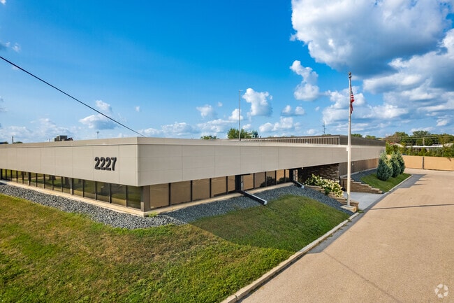
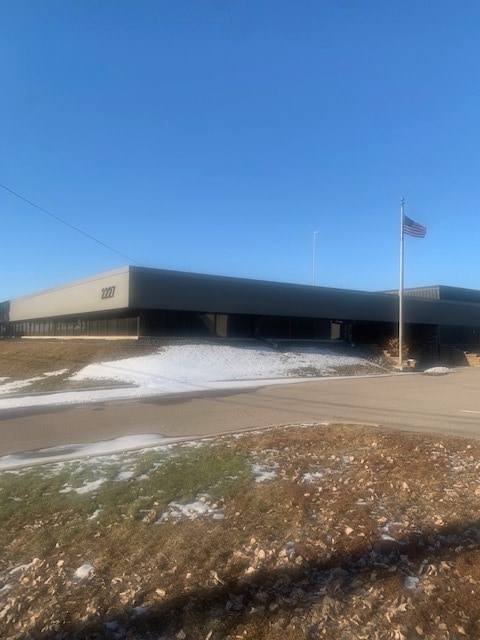
Property Record
2227 7Th St Nw, Rochester, MN 55901

NEARBY LISTINGS FOR SALE OR LEASE
Property Detail
2227 7Th St Nw
Rochester, MN
Valleyhigh 2Nd Sub
74.34.22.023808
SECT-34 TWP-107 RANGE-014 VALLEYHIGH 2ND SUB LOT-004 LOT 4
Warehouse
Olmsted
X
Minnesota
27109C0161F
4
2025
0.85 AC
2024
Rochester
001401
Other Market Areas
DEMOGRAPHICS near 2227 7Th St Nw
1 Mile
3 Mile
5 Mile
2024 Total Population
9,089
75,865
125,036
2029 Population
9,194
77,686
128,259
Pop Growth 2024-2029
+ 1.16%
+ 2.40%
+ 2.58%
Average Age
38
40
39
2024 Total Households
4,203
33,136
51,157
HH Growth 2024-2029
+ 1.05%
+ 2.51%
+ 2.60%
Median Household Inc
$66,409
$73,067
$82,000
Avg Household Size
2.10
2.20
2.30
2024 Avg HH Vehicles
1.00
2.00
2.00
Median Home Value
$241,849
$264,388
$278,834
Median Year Built
1978
1979
1986
Nearby Places
Map Layers
Map Styles
 Street
 Aerial
- Restaurants
- Banks
- Shops
- Fitness
- Groceries
PUBLIC TRANSPORTATION
AIRPORT
Rochester International
DRIVE
WALK
Distance
Rochester International
16 min
11.6 mi
Freight Ports
Port Milwaukee
DRIVE
WALK
Distance
Port Milwaukee
310 min
281.0 mi
SALE & LEASE HISTORY
LISTING DATE
SALE/LEASE

Mar 10, 2022
For Lease
Mar 10, 2022
For Sale
Dec 13, 2019
For Lease
Apr 06, 2017
For Lease
Nearby Properties
Address
Land Use
TOTAL SIZE
Lot Size
Zoning
Address
Land Use
TOTAL SIZE
Lot Size
Zoning
Address
Land Use
TOTAL SIZE
Lot Size
Zoning
2,238,362 SF
2.06 AC
Address
Land Use
TOTAL SIZE
Lot Size
Zoning
1,232,028 SF
2.03 AC
Address
Land Use
TOTAL SIZE
Lot Size
Zoning
2.77 AC
Address
Land Use
TOTAL SIZE
Lot Size
Zoning
791,669 SF
2.15 AC
Address
Land Use
TOTAL SIZE
Lot Size
Zoning
37,242 SF
1.06 AC
Address
Land Use
TOTAL SIZE
Lot Size
Zoning
454,243 SF
3.92 AC
Address
Land Use
TOTAL SIZE
Lot Size
Zoning
443,223 SF
4.44 AC
Address
Land Use
TOTAL SIZE
Lot Size
Zoning
448,296 SF
1.21 AC
Address
Land Use
TOTAL SIZE
Lot Size
Zoning
271,310 SF
27.90 AC
Address
Land Use
TOTAL SIZE
Lot Size
Zoning
4,612 SF
21.16 AC
Address
Land Use
TOTAL SIZE
Lot Size
Zoning
960 SF
38.12 AC
Address
Land Use
TOTAL SIZE
Lot Size
Zoning
339,724 SF
0.56 AC
Address
Land Use
TOTAL SIZE
Lot Size
Zoning
7,202 SF
52.44 AC
Address
Land Use
TOTAL SIZE
Lot Size
Zoning
0.88 AC
Address
Land Use
TOTAL SIZE
Lot Size
Zoning
13,946 SF
34.10 AC
Address
Land Use
TOTAL SIZE
Lot Size
Zoning
309,127 SF
0.67 AC
Address
Land Use
TOTAL SIZE
Lot Size
Zoning
175,078 SF
1.98 AC
Address
Land Use
TOTAL SIZE
Lot Size
Zoning
98,878 SF
0.89 AC
Address
Land Use
TOTAL SIZE
Lot Size
Zoning
180,031 SF
2.96 AC
Address
Land Use
TOTAL SIZE
Lot Size
Zoning
159,238 SF
0.65 AC
Address
Land Use
TOTAL SIZE
Lot Size
Zoning
236,769 SF
33.30 AC
Address
Land Use
TOTAL SIZE
Lot Size
Zoning
12,016 SF
20.31 AC
Address
Land Use
TOTAL SIZE
Lot Size
Zoning
2,420 SF
10.37 AC
Address
Land Use
TOTAL SIZE
Lot Size
Zoning
195,039 SF
8.25 AC
Address
Land Use
TOTAL SIZE
Lot Size
Zoning
423,328 SF
1.89 AC
Address
Land Use
TOTAL SIZE
Lot Size
Zoning
192,929 SF
1.12 AC
Address
Land Use
TOTAL SIZE
Lot Size
Zoning
Address
Land Use
TOTAL SIZE
Lot Size
Zoning
53.73 AC
Address
Land Use
TOTAL SIZE
Lot Size
Zoning
167.09 AC
The World's #1 Commercial Real Estate Marketplace
Connect with us
© 2025 CoStar Group
The information above has been obtained from sources believed reliable. While we do not doubt its accuracy we have not verified it and make no guarantee, warranty or representation about it. It is your responsibility to independently confirm its accuracy and completeness. Any projections, opinions, assumptions, or estimates used are for example only and do not represent the current or future performance of the property. The value of this transaction to you depends on tax and other factors which should be evaluated by your tax, financial, and legal advisors. You and your advisors should conduct a careful, independent investigation of the property to determine to your satisfaction the suitability of the property for your needs.