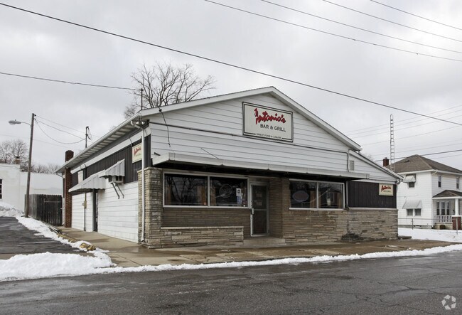
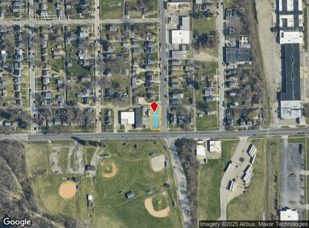
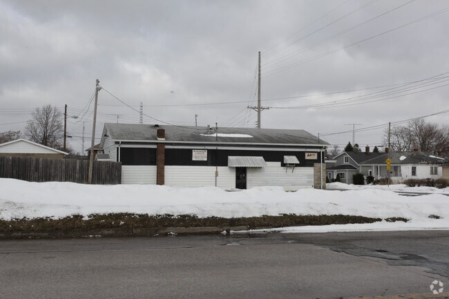
Property Record
2227 Franklin St, South Bend, IN 46613
NEARBY LISTINGS FOR SALE OR LEASE
Property Detail
2227 Franklin St
South Bend-Mishawaka, IN-MI
Citizens Homes Co Replat
71-08-14-481-032.000-026
LOT 306 CITIZENS HOMES CO REPLAT OF SHIVELYS 1ST ADD
Restaurantbuilding
St Joseph
X
Indiana
18141C0194D
306
2023
0.14 AC
2024
Greater South Bend
003400
South Bend/Mishawaka
3,925 SF
DEMOGRAPHICS near 2227 Franklin St
1 Mile
3 Mile
5 Mile
2024 Total Population
9,722
80,234
161,603
2029 Population
9,791
80,929
162,157
Pop Growth 2024-2029
+ 0.71%
+ 0.87%
+ 0.34%
Average Age
34
37
37
2024 Total Households
3,474
31,386
63,442
HH Growth 2024-2029
+ 0.58%
+ 0.81%
+ 0.35%
Median Household Inc
$45,602
$48,722
$48,712
Avg Household Size
2.60
2.40
2.30
2024 Avg HH Vehicles
2.00
2.00
2.00
Median Home Value
$70,686
$112,959
$124,137
Median Year Built
1948
1953
1958
Nearby Places
Map Layers
Map Styles
 Street
 Aerial
- Restaurants
- Banks
- Shops
- Fitness
- Groceries
PUBLIC TRANSPORTATION
COMMUTER RAIL
South Bend Amtrak Station (Capitol Limited - Amtrak, Lake Shore Limited - Amtrak)
DRIVE
WALK
Distance
South Bend Amtrak Station (Capitol Limited - Amtrak, Lake Shore Limited - Amtrak)
8 min
3.9 mi
South Bend Airport Station (South Shore Line - Northern Indiana Commuter Transportation District (South Shore Line))
DRIVE
WALK
Distance
South Bend Airport Station (South Shore Line - Northern Indiana Commuter Transportation District (South Shore Line))
12 min
5.8 mi
AIRPORT
South Bend International
DRIVE
WALK
Distance
South Bend International
22 min
8.0 mi
Freight Ports
Port Milwaukee
DRIVE
WALK
Distance
Port Milwaukee
222 min
183.0 mi
Nearby Properties
Address
Land Use
TOTAL SIZE
Lot Size
Zoning
Address
Land Use
TOTAL SIZE
Lot Size
Zoning
685,709 SF
44 SF
Address
Land Use
TOTAL SIZE
Lot Size
Zoning
291,729 SF
0.79 AC
Address
Land Use
TOTAL SIZE
Lot Size
Zoning
206,651 SF
1.68 AC
Address
Land Use
TOTAL SIZE
Lot Size
Zoning
393,123 SF
2.91 AC
Address
Land Use
TOTAL SIZE
Lot Size
Zoning
270,484 SF
131 SF
Address
Land Use
TOTAL SIZE
Lot Size
Zoning
207,846 SF
2.33 AC
Address
Land Use
TOTAL SIZE
Lot Size
Zoning
338,816 SF
33.65 AC
Address
Land Use
TOTAL SIZE
Lot Size
Zoning
283,481 SF
51.29 AC
Address
Land Use
TOTAL SIZE
Lot Size
Zoning
158,616 SF
0.85 AC
Address
Land Use
TOTAL SIZE
Lot Size
Zoning
231,450 SF
87 SF
Address
Land Use
TOTAL SIZE
Lot Size
Zoning
167,261 SF
1.58 AC
Address
Land Use
TOTAL SIZE
Lot Size
Zoning
194,931 SF
44 SF
Address
Land Use
TOTAL SIZE
Lot Size
Zoning
161,548 SF
44 SF
Address
Land Use
TOTAL SIZE
Lot Size
Zoning
205,586 SF
4.18 AC
Address
Land Use
TOTAL SIZE
Lot Size
Zoning
25,228 SF
68.61 AC
Address
Land Use
TOTAL SIZE
Lot Size
Zoning
544,872 SF
70.95 AC
Address
Land Use
TOTAL SIZE
Lot Size
Zoning
178,111 SF
44 SF
Address
Land Use
TOTAL SIZE
Lot Size
Zoning
260,370 SF
Address
Land Use
TOTAL SIZE
Lot Size
Zoning
172,368 SF
2.22 AC
Address
Land Use
TOTAL SIZE
Lot Size
Zoning
221,887 SF
87 SF
Address
Land Use
TOTAL SIZE
Lot Size
Zoning
353.40 AC
Address
Land Use
TOTAL SIZE
Lot Size
Zoning
55,995 SF
0.78 AC
Address
Land Use
TOTAL SIZE
Lot Size
Zoning
633,136 SF
2.59 AC
Address
Land Use
TOTAL SIZE
Lot Size
Zoning
81,672 SF
1.30 AC
Address
Land Use
TOTAL SIZE
Lot Size
Zoning
165,725 SF
0.01 AC
Address
Land Use
TOTAL SIZE
Lot Size
Zoning
100,368 SF
44 SF
Address
Land Use
TOTAL SIZE
Lot Size
Zoning
138,993 SF
0.38 AC
Address
Land Use
TOTAL SIZE
Lot Size
Zoning
100,191 SF
11.72 AC
Address
Land Use
TOTAL SIZE
Lot Size
Zoning
201,264 SF
1.45 AC
Address
Land Use
TOTAL SIZE
Lot Size
Zoning
90,855 SF
3.07 AC
The World's #1 Commercial Real Estate Marketplace
Connect with us
© 2025 CoStar Group
The information above has been obtained from sources believed reliable. While we do not doubt its accuracy we have not verified it and make no guarantee, warranty or representation about it. It is your responsibility to independently confirm its accuracy and completeness. Any projections, opinions, assumptions, or estimates used are for example only and do not represent the current or future performance of the property. The value of this transaction to you depends on tax and other factors which should be evaluated by your tax, financial, and legal advisors. You and your advisors should conduct a careful, independent investigation of the property to determine to your satisfaction the suitability of the property for your needs.