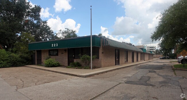
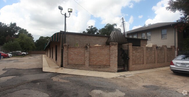
Property Record
223 Bendel Rd, Lafayette, LA 70503

Property Detail
223 Bendel Rd
6012809
SEC 47 T10S R4E (0.51 AC)(WITHIN LETTERS - ABCDEFGHIJKLMN&A ON PLAT) (LAFAYETTE HEART CLINIC)
Officebuilding
Lafayette
B and X Area of moderate flood hazard, usually the area between the limits of the 100-year and 500-year floods.
Louisiana
2025
0.51 AC
2025
Greater Lafayette
001500
Lafayette
8,632 SF
Lafayette, LA
NEARBY LISTINGS FOR SALE OR LEASE
-
-
No Photo
-
-
-
-
-
-
View all Lafayette listings for sale on LoopNet.com
DEMOGRAPHICS near 223 Bendel Rd
1 mile
3 mile
5 mile
2025 Total Population
6,180
68,506
137,694
2030 Population
6,476
71,518
143,808
Pop Growth 2025-2030
+ 4.79%
+ 4.40%
+ 4.44%
Average Age
39
40
40
2025 Total Households
2,828
30,898
59,283
HH Growth 2025-2030
+ 4.88%
+ 4.55%
+ 4.53%
Median Household Inc
$78,249
$54,234
$58,142
Avg Household Size
2.10
2.10
2.20
2025 Avg HH Vehicles
2.00
1.00
2.00
Median Home Value
$373,875
$256,863
$253,205
Median Year Built
1972
1976
1982
Nearby Places
Map Layers
Map Styles
 Street
 Aerial
Layers
 Traffic
 Biking
Places
Listings with unknown addresses are not visible on the map
- Restaurants
- Banks
- Shops
- Fitness
- Groceries
PUBLIC TRANSPORTATION
COMMUTER RAIL
Drive
Walk
Distance
6 min
2.6 mi
AIRPORT
Lafayette Regional/Paul Fournet Field
Drive
Walk
Distance
Lafayette Regional/Paul Fournet Field
7 min
3.0 mi
Freight Ports
Port of Iberia
Drive
Walk
Distance
Port of Iberia
32 min
23.1 mi
Nearby Properties
Address
Land Use
TOTAL SIZE
Lot Size
Zoning
Address
Land Use
TOTAL SIZE
Lot Size
Zoning
800,608 SF
6.64 AC
Address
Land Use
TOTAL SIZE
Lot Size
Zoning
82,329 SF
1 AC
Address
Land Use
TOTAL SIZE
Lot Size
Zoning
51,132 SF
11.07 AC
Address
Land Use
TOTAL SIZE
Lot Size
Zoning
273,165 SF
15.14 AC
Address
Land Use
TOTAL SIZE
Lot Size
Zoning
272,945 SF
21.64 AC
Address
Land Use
TOTAL SIZE
Lot Size
Zoning
141,706 SF
3.44 AC
Address
Land Use
TOTAL SIZE
Lot Size
Zoning
70,972 SF
921.26 AC
Address
Land Use
TOTAL SIZE
Lot Size
Zoning
231,380 SF
4.20 AC
Address
Land Use
TOTAL SIZE
Lot Size
Zoning
273,675 SF
6.38 AC
Address
Land Use
TOTAL SIZE
Lot Size
Zoning
443,758 SF
19.73 AC
Address
Land Use
TOTAL SIZE
Lot Size
Zoning
20,775 SF
11.04 AC
Address
Land Use
TOTAL SIZE
Lot Size
Zoning
158,272 SF
Address
Land Use
TOTAL SIZE
Lot Size
Zoning
249,875 SF
29.76 AC
Address
Land Use
TOTAL SIZE
Lot Size
Zoning
90,725 SF
17.17 AC
Address
Land Use
TOTAL SIZE
Lot Size
Zoning
145,412 SF
0.01 AC
Address
Land Use
TOTAL SIZE
Lot Size
Zoning
45,651 SF
7.44 AC
Address
Land Use
TOTAL SIZE
Lot Size
Zoning
96.54 AC
Address
Land Use
TOTAL SIZE
Lot Size
Zoning
16.16 AC
Address
Land Use
TOTAL SIZE
Lot Size
Zoning
221,760 SF
0.67 AC
Address
Land Use
TOTAL SIZE
Lot Size
Zoning
67,949 SF
0.92 AC
Address
Land Use
TOTAL SIZE
Lot Size
Zoning
11,778 SF
15.25 AC
Address
Land Use
TOTAL SIZE
Lot Size
Zoning
32.14 AC
Address
Land Use
TOTAL SIZE
Lot Size
Zoning
98,973 SF
9.91 AC
Address
Land Use
TOTAL SIZE
Lot Size
Zoning
900 SF
12.41 AC
Address
Land Use
TOTAL SIZE
Lot Size
Zoning
30,773 SF
5.12 AC
Address
Land Use
TOTAL SIZE
Lot Size
Zoning
92,556 SF
10.75 AC
Address
Land Use
TOTAL SIZE
Lot Size
Zoning
47,960 SF
3.97 AC
Address
Land Use
TOTAL SIZE
Lot Size
Zoning
84,225 SF
Address
Land Use
TOTAL SIZE
Lot Size
Zoning
194,912 SF
13.73 AC
Address
Land Use
TOTAL SIZE
Lot Size
Zoning
74,343 SF
8.88 AC
The World's #1 Commercial Real Estate Marketplace
Connect with us
© 2026 CoStar Group
The information above has been obtained from sources believed reliable. While we do not doubt its accuracy we have not verified it and make no guarantee, warranty or representation about it. It is your responsibility to independently confirm its accuracy and completeness. Any projections, opinions, assumptions, or estimates used are for example only and do not represent the current or future performance of the property. The value of this transaction to you depends on tax and other factors which should be evaluated by your tax, financial, and legal advisors. You and your advisors should conduct a careful, independent investigation of the property to determine to your satisfaction the suitability of the property for your needs.