Property Record
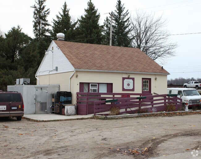
223 E Main St, Potterville, MI 48876


NEARBY LISTINGS FOR SALE OR LEASE
-
-
View all Potterville listings for sale on LoopNet.com
Property Detail
223 E Main St
700-023-400-800-01
COM SE COR SEC 23; N0 05'45"W 1320.46 FT TO SE COR OF NE 1/4 OF SE 1/4; N0 05'45"W 66 FT; N89 56'31"W 50 FT TO WEST R/W OF M-100 & POB; N89 56'31"W 150 FT; N0 05'45"W 96 FT; S89 56'31"E 150 FT TO HWY R/W; S0 05'45"E 96 FT TO POB. SEC 23, T3N,R4W, CIT
Restaurantbuilding
Eaton
A
Michigan
26065C0115D
0.33 AC
2024
Outlying Eaton County
2025
West Michigan
020601
Lansing-East Lansing, MI
780 SF
DEMOGRAPHICS near 223 E Main St
1 mile
3 mile
5 mile
2024 Total Population
3,033
5,423
12,565
2029 Population
3,017
5,395
12,501
Pop Growth 2024-2029
(0.53%)
(0.52%)
(0.51%)
Average Age
38
40
43
2024 Total Households
1,168
2,111
5,001
HH Growth 2024-2029
(0.51%)
(0.52%)
(0.54%)
Median Household Inc
$58,111
$67,500
$75,903
Avg Household Size
2.60
2.50
2.50
2024 Avg HH Vehicles
2.00
2.00
2.00
Median Home Value
$144,494
$183,250
$213,885
Median Year Built
1986
1980
1980
Nearby Places
Map Layers
Map Styles
 Street
 Aerial
Transit
 Traffic
 Biking
Places
Listings with unknown addresses are not visible on the map
- Restaurants
- Banks
- Shops
- Fitness
- Groceries
PUBLIC TRANSPORTATION
AIRPORT
Capital Region International
Drive
Walk
Distance
Capital Region International
25 min
17.2 mi
Nearby Properties
Address
Land Use
TOTAL SIZE
Lot Size
Zoning
Address
Land Use
TOTAL SIZE
Lot Size
Zoning
545,421 SF
120.99 AC
I-1 INDUST
Address
Land Use
TOTAL SIZE
Lot Size
Zoning
89,356 SF
49.53 AC
Address
Land Use
TOTAL SIZE
Lot Size
Zoning
80,900 SF
8.13 AC
I-1 INDUST
Address
Land Use
TOTAL SIZE
Lot Size
Zoning
437,864 SF
Address
Land Use
TOTAL SIZE
Lot Size
Zoning
4,249 SF
58.18 AC
R-4 MHP PA
Address
Land Use
TOTAL SIZE
Lot Size
Zoning
31.03 AC
R-2 MED RE
Address
Land Use
TOTAL SIZE
Lot Size
Zoning
4,160 SF
11.88 AC
LA
Address
Land Use
TOTAL SIZE
Lot Size
Zoning
30,964 SF
8.36 AC
I
Address
Land Use
TOTAL SIZE
Lot Size
Zoning
20,856 SF
2.21 AC
Address
Land Use
TOTAL SIZE
Lot Size
Zoning
30,100 SF
3.79 AC
Address
Land Use
TOTAL SIZE
Lot Size
Zoning
24,556 SF
1.52 AC
R-3 HIGH R
Address
Land Use
TOTAL SIZE
Lot Size
Zoning
2,137 SF
157.95 AC
LA
Address
Land Use
TOTAL SIZE
Lot Size
Zoning
3,445 SF
64.85 AC
LA
Address
Land Use
TOTAL SIZE
Lot Size
Zoning
239.56 AC
LA
Address
Land Use
TOTAL SIZE
Lot Size
Zoning
3,914 SF
8.40 AC
R1
Address
Land Use
TOTAL SIZE
Lot Size
Zoning
84.81 AC
R-R RURAL
Address
Land Use
TOTAL SIZE
Lot Size
Zoning
5,420 SF
2.22 AC
R-3 HIGH R
Address
Land Use
TOTAL SIZE
Lot Size
Zoning
14,896 SF
5.93 AC
M-1
Address
Land Use
TOTAL SIZE
Lot Size
Zoning
14,608 SF
0.67 AC
R-3 HIGH R
Address
Land Use
TOTAL SIZE
Lot Size
Zoning
1,700 SF
160.87 AC
LA
Address
Land Use
TOTAL SIZE
Lot Size
Zoning
6,020 SF
40.09 AC
LA
Address
Land Use
TOTAL SIZE
Lot Size
Zoning
2,468 SF
1.05 AC
R1
Address
Land Use
TOTAL SIZE
Lot Size
Zoning
2,937 SF
18.33 AC
R1
Address
Land Use
TOTAL SIZE
Lot Size
Zoning
3,491 SF
1.50 AC
B-2 LIGHT
Address
Land Use
TOTAL SIZE
Lot Size
Zoning
364.89 AC
LA
Address
Land Use
TOTAL SIZE
Lot Size
Zoning
1,525 SF
109.17 AC
LA
Address
Land Use
TOTAL SIZE
Lot Size
Zoning
6,324 SF
8.18 AC
M-1
Address
Land Use
TOTAL SIZE
Lot Size
Zoning
7,840 SF
1.19 AC
R-3 HIGH R
Address
Land Use
TOTAL SIZE
Lot Size
Zoning
4,322 SF
39 AC
C2
Address
Land Use
TOTAL SIZE
Lot Size
Zoning
2,161 SF
0.85 AC
R1
The World's #1 Commercial Real Estate Marketplace
Connect with us
© 2026 CoStar Group
The information above has been obtained from sources believed reliable. While we do not doubt its accuracy we have not verified it and make no guarantee, warranty or representation about it. It is your responsibility to independently confirm its accuracy and completeness. Any projections, opinions, assumptions, or estimates used are for example only and do not represent the current or future performance of the property. The value of this transaction to you depends on tax and other factors which should be evaluated by your tax, financial, and legal advisors. You and your advisors should conduct a careful, independent investigation of the property to determine to your satisfaction the suitability of the property for your needs.