Property Record
223 E X St, Deer Park, TX 77536
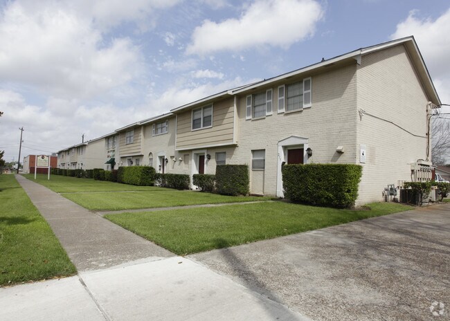

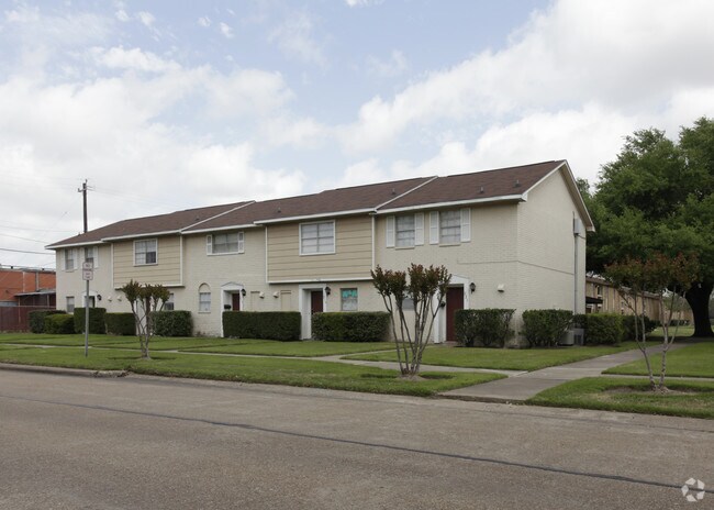

Property Detail
223 E X St
0113190000097
TRS 95C & 96C DEER PARK OUTLOTS
Apartment
HARRIS
B and X Area of moderate flood hazard, usually the area between the limits of the 100-year and 500-year floods.
Texas
2024
1.74 AC
2025
Southeast Houston
342700
Houston
21,112 SF
Houston-Pasadena-The Woodlands, TX
NEARBY LISTINGS FOR SALE OR LEASE
-
-
View all Deer Park listings for sale on LoopNet.com
DEMOGRAPHICS near 223 E X St
1 mile
3 mile
5 mile
2025 Total Population
11,570
73,801
170,451
2030 Population
12,210
79,067
181,753
Pop Growth 2025-2030
+ 5.53%
+ 7.14%
+ 6.63%
Average Age
39
38
38
2025 Total Households
4,162
25,415
58,482
HH Growth 2025-2030
+ 5.74%
+ 7.30%
+ 6.78%
Median Household Inc
$97,207
$77,003
$74,676
Avg Household Size
2.70
2.80
2.90
2025 Avg HH Vehicles
2.00
2.00
2.00
Median Home Value
$290,951
$247,010
$245,286
Median Year Built
1976
1979
1980
Nearby Places
Map Layers
Map Styles
 Street
 Aerial
Layers
 Traffic
 Biking
Places
Listings with unknown addresses are not visible on the map
- Restaurants
- Banks
- Shops
- Fitness
- Groceries
PUBLIC TRANSPORTATION
AIRPORT
William P Hobby
Drive
Walk
Distance
William P Hobby
29 min
15.7 mi
George Bush Intcntl/Houston
Drive
Walk
Distance
George Bush Intcntl/Houston
39 min
30.1 mi
Freight Ports
Port of Houston
Drive
Walk
Distance
Port of Houston
21 min
13.0 mi
Nearby Properties
Address
Land Use
TOTAL SIZE
Lot Size
Zoning
Address
Land Use
TOTAL SIZE
Lot Size
Zoning
55.98 AC
Address
Land Use
TOTAL SIZE
Lot Size
Zoning
Address
Land Use
TOTAL SIZE
Lot Size
Zoning
188.11 AC
Address
Land Use
TOTAL SIZE
Lot Size
Zoning
263.71 AC
Address
Land Use
TOTAL SIZE
Lot Size
Zoning
167.71 AC
Address
Land Use
TOTAL SIZE
Lot Size
Zoning
67.91 AC
Address
Land Use
TOTAL SIZE
Lot Size
Zoning
64.83 AC
Address
Land Use
TOTAL SIZE
Lot Size
Zoning
19.38 AC
Address
Land Use
TOTAL SIZE
Lot Size
Zoning
13.76 AC
Address
Land Use
TOTAL SIZE
Lot Size
Zoning
102.48 AC
Address
Land Use
TOTAL SIZE
Lot Size
Zoning
Address
Land Use
TOTAL SIZE
Lot Size
Zoning
153.75 AC
Address
Land Use
TOTAL SIZE
Lot Size
Zoning
900,000 SF
42.88 AC
Address
Land Use
TOTAL SIZE
Lot Size
Zoning
155.61 AC
Address
Land Use
TOTAL SIZE
Lot Size
Zoning
711,094 SF
35.47 AC
Address
Land Use
TOTAL SIZE
Lot Size
Zoning
606,550 SF
31.17 AC
Address
Land Use
TOTAL SIZE
Lot Size
Zoning
22.02 AC
Address
Land Use
TOTAL SIZE
Lot Size
Zoning
188.11 AC
Address
Land Use
TOTAL SIZE
Lot Size
Zoning
371,097 SF
10.32 AC
Address
Land Use
TOTAL SIZE
Lot Size
Zoning
411,046 SF
46.92 AC
Address
Land Use
TOTAL SIZE
Lot Size
Zoning
Address
Land Use
TOTAL SIZE
Lot Size
Zoning
265,567 SF
14.86 AC
Address
Land Use
TOTAL SIZE
Lot Size
Zoning
488,281 SF
26.48 AC
Address
Land Use
TOTAL SIZE
Lot Size
Zoning
155.74 AC
Address
Land Use
TOTAL SIZE
Lot Size
Zoning
414,900 SF
25.29 AC
Address
Land Use
TOTAL SIZE
Lot Size
Zoning
176.73 AC
Address
Land Use
TOTAL SIZE
Lot Size
Zoning
403,572 SF
24.68 AC
Address
Land Use
TOTAL SIZE
Lot Size
Zoning
2.67 AC
Address
Land Use
TOTAL SIZE
Lot Size
Zoning
2,131,181 SF
118.10 AC
Address
Land Use
TOTAL SIZE
Lot Size
Zoning
135,331 SF
5 AC
The World's #1 Commercial Real Estate Marketplace
Connect with us
© 2026 CoStar Group
The information above has been obtained from sources believed reliable. While we do not doubt its accuracy we have not verified it and make no guarantee, warranty or representation about it. It is your responsibility to independently confirm its accuracy and completeness. Any projections, opinions, assumptions, or estimates used are for example only and do not represent the current or future performance of the property. The value of this transaction to you depends on tax and other factors which should be evaluated by your tax, financial, and legal advisors. You and your advisors should conduct a careful, independent investigation of the property to determine to your satisfaction the suitability of the property for your needs.