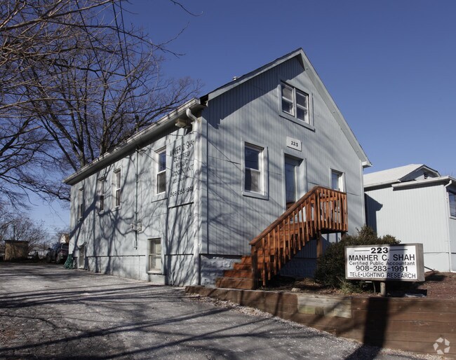
Property Record
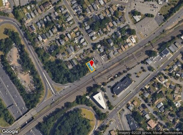
223 State Route 27, Iselin, NJ 08830

NEARBY LISTINGS FOR SALE OR LEASE
Property Detail
223 State Route 27
25-00438-0000-00017
40 X 98
Commercialnec
Middlesex
X
New Jersey
34023C0054F
17
2024
0.09 AC
2025
North Edison/Woodbridge
002500
Northern New Jersey
748 SF
New York-Jersey City-White Plains, NY-NJ
DEMOGRAPHICS near 223 State Route 27
1 Mile
3 Mile
5 Mile
2024 Total Population
15,847
148,179
329,807
2029 Population
15,715
147,401
326,872
Pop Growth 2024-2029
(0.83%)
(0.53%)
(0.89%)
Average Age
41
41
40
2024 Total Households
4,956
52,136
115,241
HH Growth 2024-2029
(0.91%)
(0.64%)
(0.95%)
Median Household Inc
$113,518
$114,436
$105,203
Avg Household Size
3.10
2.80
2.80
2024 Avg HH Vehicles
2.00
2.00
2.00
Median Home Value
$408,571
$413,569
$417,038
Median Year Built
1958
1964
1964
Nearby Places
Map Layers
Map Styles
 Street
 Aerial
- Restaurants
- Banks
- Shops
- Fitness
- Groceries
PUBLIC TRANSPORTATION
COMMUTER RAIL
Metropark (Northeast Corridor Line - NJ Transit Commuter Rail (NJ Transit))
DRIVE
WALK
Distance
Metropark (Northeast Corridor Line - NJ Transit Commuter Rail (NJ Transit))
0 min
9 min
0.4 mi
Avenel (North Jersey Coast Line - NJ Transit Commuter Rail (NJ Transit))
DRIVE
WALK
Distance
Avenel (North Jersey Coast Line - NJ Transit Commuter Rail (NJ Transit))
7 min
3.3 mi
AIRPORT
Newark Liberty International
DRIVE
WALK
Distance
Newark Liberty International
21 min
17.5 mi
LaGuardia
DRIVE
WALK
Distance
LaGuardia
56 min
36.8 mi
John F Kennedy International
DRIVE
WALK
Distance
John F Kennedy International
59 min
41.5 mi
Freight Ports
New York Container Terminal
DRIVE
WALK
Distance
New York Container Terminal
20 min
14.1 mi
Nearby Properties
Address
Land Use
TOTAL SIZE
Lot Size
Zoning
Address
Land Use
TOTAL SIZE
Lot Size
Zoning
37.46 AC
EI
Address
Land Use
TOTAL SIZE
Lot Size
Zoning
65.84 AC
PB
Address
Land Use
TOTAL SIZE
Lot Size
Zoning
80,000 SF
23.37 AC
R50
Address
Land Use
TOTAL SIZE
Lot Size
Zoning
0.14 AC
C-4
Address
Land Use
TOTAL SIZE
Lot Size
Zoning
0.66 AC
C-4
Address
Land Use
TOTAL SIZE
Lot Size
Zoning
96.22 AC
RA
Address
Land Use
TOTAL SIZE
Lot Size
Zoning
191.81 AC
R75
Address
Land Use
TOTAL SIZE
Lot Size
Zoning
5,645 SF
91.16 AC
O
Address
Land Use
TOTAL SIZE
Lot Size
Zoning
65.20 AC
Address
Land Use
TOTAL SIZE
Lot Size
Zoning
3.18 AC
Address
Land Use
TOTAL SIZE
Lot Size
Zoning
10,173 SF
14.04 AC
OR
Address
Land Use
TOTAL SIZE
Lot Size
Zoning
43.63 AC
MF
Address
Land Use
TOTAL SIZE
Lot Size
Zoning
5.83 AC
RO
Address
Land Use
TOTAL SIZE
Lot Size
Zoning
15.55 AC
Address
Land Use
TOTAL SIZE
Lot Size
Zoning
19.50 AC
LR
Address
Land Use
TOTAL SIZE
Lot Size
Zoning
6.10 AC
RO
Address
Land Use
TOTAL SIZE
Lot Size
Zoning
22.50 AC
LR
Address
Land Use
TOTAL SIZE
Lot Size
Zoning
74.58 AC
B4
Address
Land Use
TOTAL SIZE
Lot Size
Zoning
Address
Land Use
TOTAL SIZE
Lot Size
Zoning
26.50 AC
LR
Address
Land Use
TOTAL SIZE
Lot Size
Zoning
11.49 AC
RO
Address
Land Use
TOTAL SIZE
Lot Size
Zoning
11.25 AC
LI
Address
Land Use
TOTAL SIZE
Lot Size
Zoning
261,144 SF
10.14 AC
OR
Address
Land Use
TOTAL SIZE
Lot Size
Zoning
26 AC
R1
Address
Land Use
TOTAL SIZE
Lot Size
Zoning
10.91 AC
OR
Address
Land Use
TOTAL SIZE
Lot Size
Zoning
1.27 AC
Address
Land Use
TOTAL SIZE
Lot Size
Zoning
22 AC
P
Address
Land Use
TOTAL SIZE
Lot Size
Zoning
2,795 SF
137.05 AC
Address
Land Use
TOTAL SIZE
Lot Size
Zoning
20.27 AC
PB
Address
Land Use
TOTAL SIZE
Lot Size
Zoning
7.16 AC
The World's #1 Commercial Real Estate Marketplace
Connect with us
© 2025 CoStar Group
The information above has been obtained from sources believed reliable. While we do not doubt its accuracy we have not verified it and make no guarantee, warranty or representation about it. It is your responsibility to independently confirm its accuracy and completeness. Any projections, opinions, assumptions, or estimates used are for example only and do not represent the current or future performance of the property. The value of this transaction to you depends on tax and other factors which should be evaluated by your tax, financial, and legal advisors. You and your advisors should conduct a careful, independent investigation of the property to determine to your satisfaction the suitability of the property for your needs.