Property Record
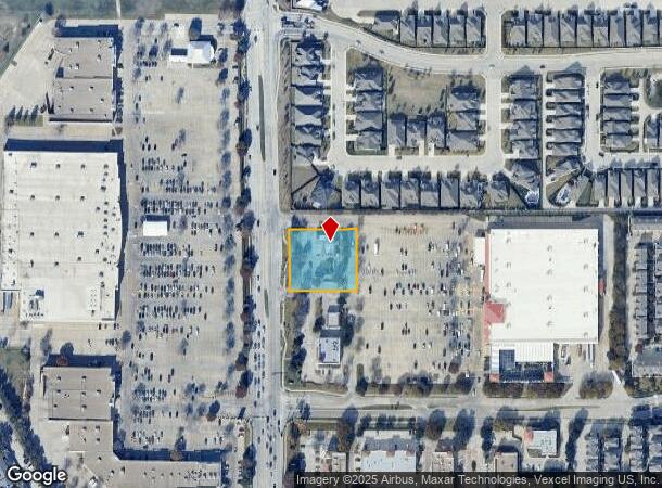
2230 N Coit Rd, Richardson, TX 75080

NEARBY LISTINGS FOR SALE OR LEASE
Property Detail
2230 N Coit Rd
Dallas-Fort Worth-Arlington, TX
University World
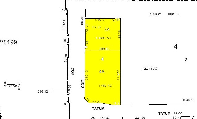
422597000403A0000
UNIVERSITY WORLD BLK 4 LT 3A ACS 0.8694 INT200600477693 DD12282006 CO-DC 2597000403A00 3CR25970004
Restaurantdrivein
Dallas
X
Texas
48085C0482K
3a
2024
0.87 AC
2025
Richardson
019205
Dallas/Ft Worth
2,908 SF
DEMOGRAPHICS near 2230 N Coit Rd
1 Mile
3 Mile
5 Mile
2024 Total Population
22,397
131,252
379,110
2029 Population
24,480
142,858
417,051
Pop Growth 2024-2029
+ 9.30%
+ 8.84%
+ 10.01%
Average Age
33
39
39
2024 Total Households
7,649
53,386
166,111
HH Growth 2024-2029
+ 12.69%
+ 10.22%
+ 10.47%
Median Household Inc
$54,826
$79,364
$74,050
Avg Household Size
2.20
2.30
2.20
2024 Avg HH Vehicles
1.00
2.00
2.00
Median Home Value
$448,162
$418,471
$391,597
Median Year Built
1984
1980
1985
Nearby Places
Map Layers
Map Styles
 Street
 Aerial
- Restaurants
- Banks
- Shops
- Fitness
- Groceries
PUBLIC TRANSPORTATION
AIRPORT
Dallas Love Field
DRIVE
WALK
Distance
Dallas Love Field
26 min
15.9 mi
Dallas-Fort Worth International
DRIVE
WALK
Distance
Dallas-Fort Worth International
32 min
24.8 mi
Nearby Properties
Address
Land Use
TOTAL SIZE
Lot Size
Zoning
Address
Land Use
TOTAL SIZE
Lot Size
Zoning
1,049,441 SF
Address
Land Use
TOTAL SIZE
Lot Size
Zoning
1,614,550 SF
77.76 AC
SFR
Address
Land Use
TOTAL SIZE
Lot Size
Zoning
492,661 SF
4.89 AC
Address
Land Use
TOTAL SIZE
Lot Size
Zoning
343,539 SF
34.74 AC
S-164
Address
Land Use
TOTAL SIZE
Lot Size
Zoning
1,105,509 SF
92.46 AC
A
Address
Land Use
TOTAL SIZE
Lot Size
Zoning
659,402 SF
24.39 AC
O-M
Address
Land Use
TOTAL SIZE
Lot Size
Zoning
686,032 SF
9 AC
R2000
Address
Land Use
TOTAL SIZE
Lot Size
Zoning
369,694 SF
Address
Land Use
TOTAL SIZE
Lot Size
Zoning
533,962 SF
29.78 AC
MF-M
Address
Land Use
TOTAL SIZE
Lot Size
Zoning
445,071 SF
107.94 AC
2493-A TO-
Address
Land Use
TOTAL SIZE
Lot Size
Zoning
481,366 SF
6.31 AC
LC
Address
Land Use
TOTAL SIZE
Lot Size
Zoning
430,618 SF
11.33 AC
MF-H
Address
Land Use
TOTAL SIZE
Lot Size
Zoning
394,287 SF
14.96 AC
Address
Land Use
TOTAL SIZE
Lot Size
Zoning
507,693 SF
32.50 AC
MFL
Address
Land Use
TOTAL SIZE
Lot Size
Zoning
520,713 SF
8.03 AC
Address
Land Use
TOTAL SIZE
Lot Size
Zoning
393,416 SF
Address
Land Use
TOTAL SIZE
Lot Size
Zoning
706,061 SF
36.76 AC
Z109
Address
Land Use
TOTAL SIZE
Lot Size
Zoning
451,672 SF
23.81 AC
LI-1
Address
Land Use
TOTAL SIZE
Lot Size
Zoning
289,093 SF
8.87 AC
R/O-2
Address
Land Use
TOTAL SIZE
Lot Size
Zoning
284,830 SF
2.98 AC
Address
Land Use
TOTAL SIZE
Lot Size
Zoning
386,448 SF
Address
Land Use
TOTAL SIZE
Lot Size
Zoning
421,532 SF
4.29 AC
Address
Land Use
TOTAL SIZE
Lot Size
Zoning
488,063 SF
31.19 AC
MF-L
Address
Land Use
TOTAL SIZE
Lot Size
Zoning
260,608 SF
18.68 AC
COMM
Address
Land Use
TOTAL SIZE
Lot Size
Zoning
211,607 SF
Address
Land Use
TOTAL SIZE
Lot Size
Zoning
387,098 SF
18.40 AC
MF-29
Address
Land Use
TOTAL SIZE
Lot Size
Zoning
302,594 SF
16.02 AC
TO-M
Address
Land Use
TOTAL SIZE
Lot Size
Zoning
299,130 SF
14.73 AC
R/O-M
Address
Land Use
TOTAL SIZE
Lot Size
Zoning
282,695 SF
3.32 AC
The World's #1 Commercial Real Estate Marketplace
Connect with us
© 2025 CoStar Group
The information above has been obtained from sources believed reliable. While we do not doubt its accuracy we have not verified it and make no guarantee, warranty or representation about it. It is your responsibility to independently confirm its accuracy and completeness. Any projections, opinions, assumptions, or estimates used are for example only and do not represent the current or future performance of the property. The value of this transaction to you depends on tax and other factors which should be evaluated by your tax, financial, and legal advisors. You and your advisors should conduct a careful, independent investigation of the property to determine to your satisfaction the suitability of the property for your needs.