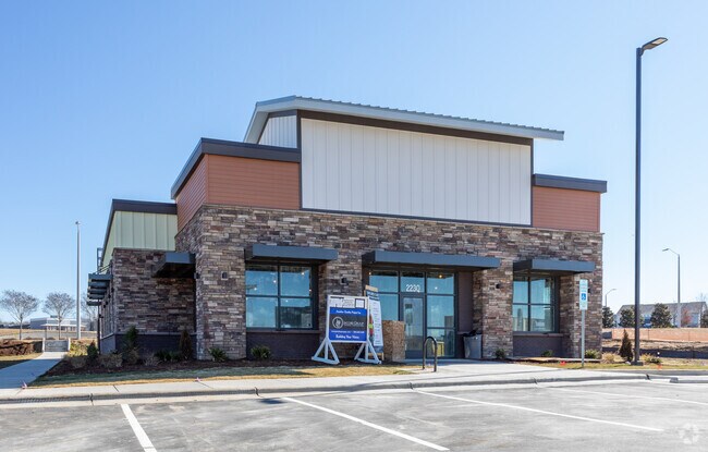
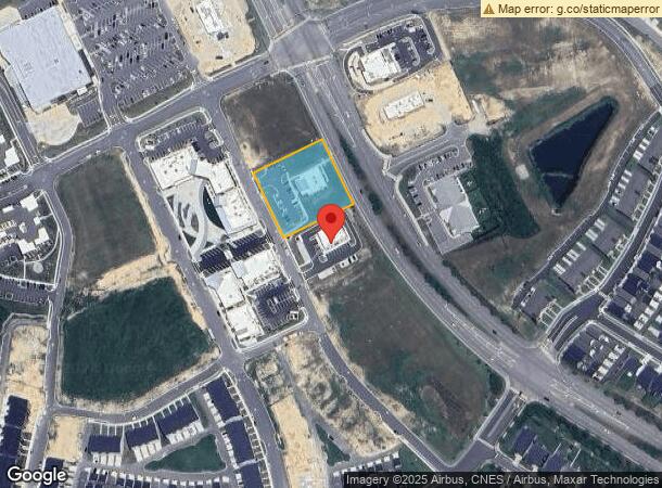
Property Record
2230 Treelight Way, Wendell, NC 27591

NEARBY LISTINGS FOR SALE OR LEASE
Property Detail
2230 Treelight Way
Raleigh, NC
Wendell Falls Treelight
1763.02-87-0650-000
LO21 WENDELL FALLS TREELIGHT BM2020-0091
Medicalbuilding
Wake
X
North Carolina
3720176300K
21
2025
1.09 AC
2025
Northeast Wake County
054402
Raleigh/Durham
4,290 SF
DEMOGRAPHICS near 2230 Treelight Way
1 Mile
3 Mile
5 Mile
2024 Total Population
5,815
20,273
53,983
2029 Population
6,601
22,601
59,334
Pop Growth 2024-2029
+ 13.52%
+ 11.48%
+ 9.91%
Average Age
38
38
38
2024 Total Households
2,192
7,509
19,698
HH Growth 2024-2029
+ 13.69%
+ 11.59%
+ 9.96%
Median Household Inc
$103,315
$85,765
$78,008
Avg Household Size
2.70
2.70
2.70
2024 Avg HH Vehicles
2.00
2.00
2.00
Median Home Value
$325,000
$303,876
$276,192
Median Year Built
2010
2002
2000
Nearby Places
Map Layers
Map Styles
 Street
 Aerial
- Restaurants
- Banks
- Shops
- Fitness
- Groceries
PUBLIC TRANSPORTATION
AIRPORT
Raleigh-Durham International
DRIVE
WALK
Distance
Raleigh-Durham International
37 min
29.7 mi
Freight Ports
Port of Wilmington
DRIVE
WALK
Distance
Port of Wilmington
162 min
140.5 mi
SALE & LEASE HISTORY
LISTING DATE
SALE/LEASE

Mar 15, 2023
For Sale
Nearby Properties
Address
Land Use
TOTAL SIZE
Lot Size
Zoning
Address
Land Use
TOTAL SIZE
Lot Size
Zoning
377,673 SF
27.54 AC
PUD-1
Address
Land Use
TOTAL SIZE
Lot Size
Zoning
176,286 SF
103.50 AC
CMX
Address
Land Use
TOTAL SIZE
Lot Size
Zoning
392,729 SF
72.10 AC
CU-O&
Address
Land Use
TOTAL SIZE
Lot Size
Zoning
301,933 SF
12.92 AC
PUD-1
Address
Land Use
TOTAL SIZE
Lot Size
Zoning
328,918 SF
17.24 AC
CMX-C
Address
Land Use
TOTAL SIZE
Lot Size
Zoning
209,019 SF
5 AC
NMX P
Address
Land Use
TOTAL SIZE
Lot Size
Zoning
356,188 SF
31.21 AC
MI-CD
Address
Land Use
TOTAL SIZE
Lot Size
Zoning
222,108 SF
21.81 AC
UR12
Address
Land Use
TOTAL SIZE
Lot Size
Zoning
411,764 SF
59.16 AC
MI
Address
Land Use
TOTAL SIZE
Lot Size
Zoning
152,472 SF
24.42 AC
R-40
Address
Land Use
TOTAL SIZE
Lot Size
Zoning
81,915 SF
18.72 AC
CH
Address
Land Use
TOTAL SIZE
Lot Size
Zoning
61,750 SF
12.01 AC
PUD-1
Address
Land Use
TOTAL SIZE
Lot Size
Zoning
105,512 SF
17.63 AC
R3
Address
Land Use
TOTAL SIZE
Lot Size
Zoning
63,414 SF
95.15 AC
RT
Address
Land Use
TOTAL SIZE
Lot Size
Zoning
66,695 SF
19.89 AC
NC
Address
Land Use
TOTAL SIZE
Lot Size
Zoning
86,168 SF
19.65 AC
RA
Address
Land Use
TOTAL SIZE
Lot Size
Zoning
41,572 SF
43.57 AC
CMX-C
Address
Land Use
TOTAL SIZE
Lot Size
Zoning
89,350 SF
21.48 AC
UR12
Address
Land Use
TOTAL SIZE
Lot Size
Zoning
201.30 AC
MI
Address
Land Use
TOTAL SIZE
Lot Size
Zoning
24,519 SF
10.79 AC
PUD-1
Address
Land Use
TOTAL SIZE
Lot Size
Zoning
867 SF
66.88 AC
NMX
Address
Land Use
TOTAL SIZE
Lot Size
Zoning
56,052 SF
31.08 AC
RT
Address
Land Use
TOTAL SIZE
Lot Size
Zoning
138,653 SF
45.85 AC
MI
Address
Land Use
TOTAL SIZE
Lot Size
Zoning
32,428 SF
4.56 AC
UR12
Address
Land Use
TOTAL SIZE
Lot Size
Zoning
17.90 AC
PUD-1
Address
Land Use
TOTAL SIZE
Lot Size
Zoning
54,085 SF
60.87 AC
R-30
Address
Land Use
TOTAL SIZE
Lot Size
Zoning
113,000 SF
7.30 AC
CU-I-
Address
Land Use
TOTAL SIZE
Lot Size
Zoning
48,976 SF
5.86 AC
PUD-1
Address
Land Use
TOTAL SIZE
Lot Size
Zoning
65,300 SF
11.64 AC
CMX
Address
Land Use
TOTAL SIZE
Lot Size
Zoning
40,897 SF
8.67 AC
CMX-C
The World's #1 Commercial Real Estate Marketplace
Connect with us
© 2025 CoStar Group
The information above has been obtained from sources believed reliable. While we do not doubt its accuracy we have not verified it and make no guarantee, warranty or representation about it. It is your responsibility to independently confirm its accuracy and completeness. Any projections, opinions, assumptions, or estimates used are for example only and do not represent the current or future performance of the property. The value of this transaction to you depends on tax and other factors which should be evaluated by your tax, financial, and legal advisors. You and your advisors should conduct a careful, independent investigation of the property to determine to your satisfaction the suitability of the property for your needs.