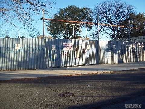
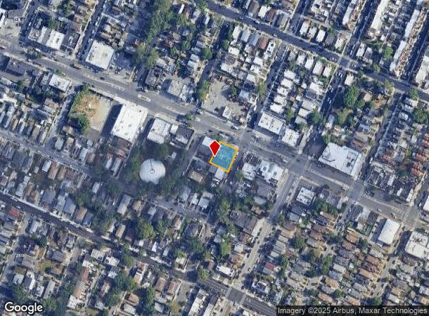
Property Record
22310 Merrick Blvd, Laurelton, NY 11413
NEARBY LISTINGS FOR SALE OR LEASE
-
-
-
-
No Photo
-
-
-
-
View all Laurelton listings for lease on LoopNet.com
Property Detail
22310 Merrick Blvd
13103-0021
Queens
Autorepair
New York
X
21
36059C0211G
0.19 AC
2024
South Queens
2025
Long Island (New York)
035800
New York-Jersey City-White Plains, NY-NJ
2,500 SF
DEMOGRAPHICS near 22310 Merrick Blvd
1 Mile
3 Mile
5 Mile
2024 Total Population
42,225
358,910
943,885
2029 Population
38,839
333,336
885,993
Pop Growth 2024-2029
(8.02%)
(7.13%)
(6.13%)
Average Age
43
41
41
2024 Total Households
13,012
108,663
297,169
HH Growth 2024-2029
(8.61%)
(7.53%)
(6.38%)
Median Household Inc
$102,313
$88,317
$89,431
Avg Household Size
3.10
3.10
3.00
2024 Avg HH Vehicles
2.00
1.00
1.00
Median Home Value
$631,045
$616,184
$657,711
Median Year Built
1949
1951
1951
Nearby Places
- Restaurants
- Banks
- Shops
- Fitness
- Groceries
PUBLIC TRANSPORTATION
COMMUTER RAIL
Laurelton Station (Far Rockaway Branch - Long Island Rail Road)
DRIVE
WALK
Distance
Laurelton Station (Far Rockaway Branch - Long Island Rail Road)
3 min
14 min
0.8 mi
Locust Manor Station (Far Rockaway Branch - Long Island Rail Road)
DRIVE
WALK
Distance
Locust Manor Station (Far Rockaway Branch - Long Island Rail Road)
5 min
1.3 mi
AIRPORT
John F Kennedy International
DRIVE
WALK
Distance
John F Kennedy International
12 min
6.7 mi
LaGuardia
DRIVE
WALK
Distance
LaGuardia
21 min
14.0 mi
Westchester County
DRIVE
WALK
Distance
Westchester County
47 min
36.6 mi
Freight Ports
NY - Red Hook Container Terminal
DRIVE
WALK
Distance
NY - Red Hook Container Terminal
1 min
13.6 mi
SALE & LEASE HISTORY
LISTING DATE
SALE/LEASE

Sep 25, 2016
For Lease
Nearby Properties
Address
Land Use
TOTAL SIZE
Lot Size
Zoning
Address
Land Use
TOTAL SIZE
Lot Size
Zoning
124.60 AC
M1-1
Address
Land Use
TOTAL SIZE
Lot Size
Zoning
294.47 AC
PARK
Address
Land Use
TOTAL SIZE
Lot Size
Zoning
731,247 SF
56.09 AC
R3-2
Address
Land Use
TOTAL SIZE
Lot Size
Zoning
208,952 SF
9.03 AC
M1-1
Address
Land Use
TOTAL SIZE
Lot Size
Zoning
285,170 SF
12.63 AC
R3-1
Address
Land Use
TOTAL SIZE
Lot Size
Zoning
27.23 AC
PARK
Address
Land Use
TOTAL SIZE
Lot Size
Zoning
50,000 SF
52.45 AC
PARK
Address
Land Use
TOTAL SIZE
Lot Size
Zoning
175,040 SF
10.19 AC
R3X
Address
Land Use
TOTAL SIZE
Lot Size
Zoning
160,551 SF
0.68 AC
C4-2
Address
Land Use
TOTAL SIZE
Lot Size
Zoning
129,378 SF
4.86 AC
R2A
Address
Land Use
TOTAL SIZE
Lot Size
Zoning
304,128 SF
3.70 AC
R6
Address
Land Use
TOTAL SIZE
Lot Size
Zoning
41,756 SF
1.02 AC
R5D
Address
Land Use
TOTAL SIZE
Lot Size
Zoning
160,000 SF
4.02 AC
R3-2
Address
Land Use
TOTAL SIZE
Lot Size
Zoning
189,693 SF
2.11 AC
R3-2
Address
Land Use
TOTAL SIZE
Lot Size
Zoning
165,600 SF
2.11 AC
R6
Address
Land Use
TOTAL SIZE
Lot Size
Zoning
233,210 SF
1.74 AC
C4-2
Address
Land Use
TOTAL SIZE
Lot Size
Zoning
197,532 SF
1.42 AC
C4-2
Address
Land Use
TOTAL SIZE
Lot Size
Zoning
93.35 AC
PARK
Address
Land Use
TOTAL SIZE
Lot Size
Zoning
615,000 SF
3.60 AC
R3-2
Address
Land Use
TOTAL SIZE
Lot Size
Zoning
178,870 SF
7.60 AC
M1-1
Address
Land Use
TOTAL SIZE
Lot Size
Zoning
122,080 SF
2.81 AC
R2
Address
Land Use
TOTAL SIZE
Lot Size
Zoning
243,100 SF
2.30 AC
R3A
Address
Land Use
TOTAL SIZE
Lot Size
Zoning
875 SF
21.59 AC
PARK
Address
Land Use
TOTAL SIZE
Lot Size
Zoning
5,296 SF
37.42 AC
PARK
Address
Land Use
TOTAL SIZE
Lot Size
Zoning
138,000 SF
7.06 AC
R3-2
Address
Land Use
TOTAL SIZE
Lot Size
Zoning
213,338 SF
2.91 AC
R3X
Address
Land Use
TOTAL SIZE
Lot Size
Zoning
199,873 SF
1.65 AC
C4-2
Address
Land Use
TOTAL SIZE
Lot Size
Zoning
104,824 SF
2.80 AC
R6
Address
Land Use
TOTAL SIZE
Lot Size
Zoning
144,474 SF
2.07 AC
R7-2
Address
Land Use
TOTAL SIZE
Lot Size
Zoning
252,665 SF
7.50 AC
R3-2
The World's #1 Commercial Real Estate Marketplace
Connect with us
© 2025 CoStar Group
The information above has been obtained from sources believed reliable. While we do not doubt its accuracy we have not verified it and make no guarantee, warranty or representation about it. It is your responsibility to independently confirm its accuracy and completeness. Any projections, opinions, assumptions, or estimates used are for example only and do not represent the current or future performance of the property. The value of this transaction to you depends on tax and other factors which should be evaluated by your tax, financial, and legal advisors. You and your advisors should conduct a careful, independent investigation of the property to determine to your satisfaction the suitability of the property for your needs.