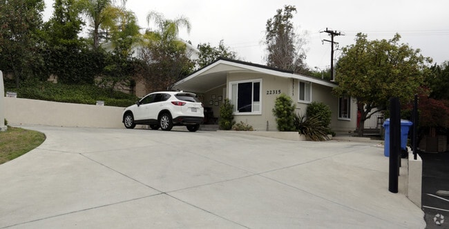
Property Record
22315 Mulholland Hwy, Calabasas, CA 91302
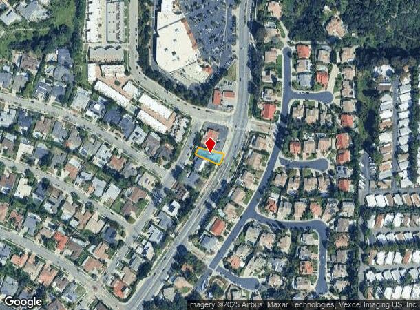


NEARBY LISTINGS FOR SALE OR LEASE
Property Detail
22315 Mulholland Hwy
Los Angeles-Long Beach-Glendale, CA
28267
2078-011-034
TRACT NO 28267 THAT PART OF LOT 13 S OF A LINE WHICH EXTENDS FROM A PT S ON A CURVE CONCAVE TO W (R=950 FT) 125 FT FROM INTERSECTION OF N CONTIN- UATION OF E LINE OF SD LOT WITH SE PROLONGATION OF LOT WITH NW PROLONGATION OF SD NE LINE
Officebuilding
Los Angeles
X
California
06037C1288G
13
2024
0.12 AC
2025
Calabasas/Westlake Vill
800101
Los Angeles
1,368 SF
DEMOGRAPHICS near 22315 Mulholland Hwy
1 Mile
3 Mile
5 Mile
2024 Total Population
11,176
84,042
235,697
2029 Population
10,802
82,204
229,545
Pop Growth 2024-2029
(3.35%)
(2.19%)
(2.61%)
Average Age
45
43
42
2024 Total Households
4,122
34,248
86,099
HH Growth 2024-2029
(3.66%)
(2.20%)
(2.68%)
Median Household Inc
$143,586
$111,303
$99,457
Avg Household Size
2.60
2.40
2.60
2024 Avg HH Vehicles
2.00
2.00
2.00
Median Home Value
$1,065,511
$1,026,918
$902,742
Median Year Built
1967
1974
1971
Nearby Places
Map Layers
Map Styles
 Street
 Aerial
- Restaurants
- Banks
- Shops
- Fitness
- Groceries
PUBLIC TRANSPORTATION
COMMUTER RAIL
Northridge (Ventura County Line - Southern California Regional Rail Authority (Metrolink))
DRIVE
WALK
Distance
Northridge (Ventura County Line - Southern California Regional Rail Authority (Metrolink))
19 min
9.9 mi
Northridge (Pacific Surfliner - Amtrak)
DRIVE
WALK
Distance
Northridge (Pacific Surfliner - Amtrak)
19 min
10.0 mi
AIRPORT
Bob Hope
DRIVE
WALK
Distance
Bob Hope
30 min
20.1 mi
Los Angeles International
DRIVE
WALK
Distance
Los Angeles International
39 min
28.2 mi
Freight Ports
The Port of Hueneme
DRIVE
WALK
Distance
The Port of Hueneme
54 min
39.3 mi
Nearby Properties
Address
Land Use
TOTAL SIZE
Lot Size
Zoning
Address
Land Use
TOTAL SIZE
Lot Size
Zoning
1,330,065 SF
28.40 AC
LAWC
Address
Land Use
TOTAL SIZE
Lot Size
Zoning
928,124 SF
19.98 AC
LAWC
Address
Land Use
TOTAL SIZE
Lot Size
Zoning
1,595,158 SF
7.95 AC
LAWC
Address
Land Use
TOTAL SIZE
Lot Size
Zoning
441,265 SF
4.56 AC
LAWC
Address
Land Use
TOTAL SIZE
Lot Size
Zoning
532,580 SF
6.94 AC
LAWC
Address
Land Use
TOTAL SIZE
Lot Size
Zoning
967,368 SF
7.87 AC
LAWC
Address
Land Use
TOTAL SIZE
Lot Size
Zoning
454,102 SF
8.35 AC
LARAS4
Address
Land Use
TOTAL SIZE
Lot Size
Zoning
484,354 SF
5.94 AC
LAWC
Address
Land Use
TOTAL SIZE
Lot Size
Zoning
426,935 SF
2.74 AC
LAWC
Address
Land Use
TOTAL SIZE
Lot Size
Zoning
394,137 SF
2.73 AC
LAWC
Address
Land Use
TOTAL SIZE
Lot Size
Zoning
365,572 SF
8.95 AC
LAR3
Address
Land Use
TOTAL SIZE
Lot Size
Zoning
623,899 SF
1.25 AC
LAWC
Address
Land Use
TOTAL SIZE
Lot Size
Zoning
583,153 SF
4.22 AC
LACR
Address
Land Use
TOTAL SIZE
Lot Size
Zoning
334,174 SF
3.84 AC
LAWC
Address
Land Use
TOTAL SIZE
Lot Size
Zoning
691,292 SF
17.78 AC
LAWC
Address
Land Use
TOTAL SIZE
Lot Size
Zoning
308,951 SF
3.19 AC
LAWC
Address
Land Use
TOTAL SIZE
Lot Size
Zoning
313,962 SF
3 AC
LAWC
Address
Land Use
TOTAL SIZE
Lot Size
Zoning
475,019 SF
1.31 AC
LAWC
Address
Land Use
TOTAL SIZE
Lot Size
Zoning
595,008 SF
18.57 AC
LAC1
Address
Land Use
TOTAL SIZE
Lot Size
Zoning
218,113 SF
7.73 AC
LAWC
Address
Land Use
TOTAL SIZE
Lot Size
Zoning
353,830 SF
12.77 AC
LAR4
Address
Land Use
TOTAL SIZE
Lot Size
Zoning
470,190 SF
5.42 AC
LAC4
Address
Land Use
TOTAL SIZE
Lot Size
Zoning
241,112 SF
5.15 AC
LAWC
Address
Land Use
TOTAL SIZE
Lot Size
Zoning
221,414 SF
6.42 AC
LAP
Address
Land Use
TOTAL SIZE
Lot Size
Zoning
200,669 SF
6.69 AC
LAWC
Address
Land Use
TOTAL SIZE
Lot Size
Zoning
329,741 SF
20.14 AC
LCC3DP*
Address
Land Use
TOTAL SIZE
Lot Size
Zoning
262,696 SF
3.14 AC
LAWC
Address
Land Use
TOTAL SIZE
Lot Size
Zoning
262,696 SF
2.69 AC
LAWC
Address
Land Use
TOTAL SIZE
Lot Size
Zoning
431,645 SF
6.28 AC
LAWC
The World's #1 Commercial Real Estate Marketplace
Connect with us
© 2025 CoStar Group
The information above has been obtained from sources believed reliable. While we do not doubt its accuracy we have not verified it and make no guarantee, warranty or representation about it. It is your responsibility to independently confirm its accuracy and completeness. Any projections, opinions, assumptions, or estimates used are for example only and do not represent the current or future performance of the property. The value of this transaction to you depends on tax and other factors which should be evaluated by your tax, financial, and legal advisors. You and your advisors should conduct a careful, independent investigation of the property to determine to your satisfaction the suitability of the property for your needs.