No Photo
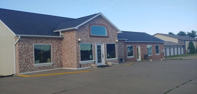
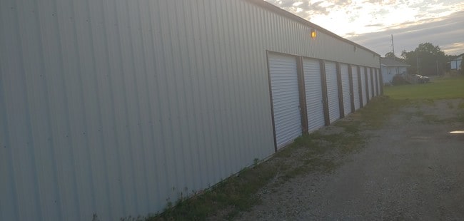
Property Record
22319 22325 & 22333, Tremont, IL 61568

NEARBY LISTINGS FOR SALE OR LEASE
-
-
View all Tremont listings for sale on LoopNet.com
Property Detail
22319 22325 & 22333
Peoria, IL
Roy Coons Subd
11-11-13-300-002
SEC 13 T24N R4W LOTS 1-2-3 OF ROY COONS SUBD (EXC PT LOT 1) SW 1/4
Storebuilding
Tazewell
X
Illinois
17179C0200E
1-2,1
2023
2.63 AC
2024
Outlying Tazewell County
021702
Peoria
16,296 SF
DEMOGRAPHICS near 22319 22325 & 22333
1 Mile
3 Mile
5 Mile
2024 Total Population
1,736
3,046
7,766
2029 Population
1,685
2,963
7,602
Pop Growth 2024-2029
(2.94%)
(2.72%)
(2.11%)
Average Age
40
41
42
2024 Total Households
684
1,191
3,100
HH Growth 2024-2029
(3.07%)
(2.77%)
(2.13%)
Median Household Inc
$71,379
$77,361
$81,195
Avg Household Size
2.50
2.50
2.50
2024 Avg HH Vehicles
2.00
2.00
2.00
Median Home Value
$194,042
$212,987
$234,297
Median Year Built
1961
1964
1973
Nearby Places
Map Layers
Map Styles
 Street
 Aerial
- Restaurants
- Banks
- Shops
- Fitness
- Groceries
PUBLIC TRANSPORTATION
AIRPORT
General Downing - Peoria International
DRIVE
WALK
Distance
General Downing - Peoria International
30 min
19.8 mi
Freight Ports
Port Milwaukee
DRIVE
WALK
Distance
Port Milwaukee
277 min
238.2 mi
SALE & LEASE HISTORY
LISTING DATE
SALE/LEASE

Jun 12, 2019
For Sale
Nearby Properties
Address
Land Use
TOTAL SIZE
Lot Size
Zoning
Address
Land Use
TOTAL SIZE
Lot Size
Zoning
1,440 SF
7.86 AC
Address
Land Use
TOTAL SIZE
Lot Size
Zoning
35,775 SF
6.99 AC
Address
Land Use
TOTAL SIZE
Lot Size
Zoning
20,348 SF
3.33 AC
Address
Land Use
TOTAL SIZE
Lot Size
Zoning
3,856 SF
0.90 AC
Address
Land Use
TOTAL SIZE
Lot Size
Zoning
6,452 SF
0.57 AC
Address
Land Use
TOTAL SIZE
Lot Size
Zoning
19,402 SF
2.74 AC
Address
Land Use
TOTAL SIZE
Lot Size
Zoning
24,726 SF
1.42 AC
Address
Land Use
TOTAL SIZE
Lot Size
Zoning
7,092 SF
0.80 AC
Address
Land Use
TOTAL SIZE
Lot Size
Zoning
7,685 SF
0.27 AC
Address
Land Use
TOTAL SIZE
Lot Size
Zoning
4,572 SF
0.67 AC
Address
Land Use
TOTAL SIZE
Lot Size
Zoning
2.82 AC
Address
Land Use
TOTAL SIZE
Lot Size
Zoning
5,544 SF
0.20 AC
Address
Land Use
TOTAL SIZE
Lot Size
Zoning
6,156 SF
0.12 AC
Address
Land Use
TOTAL SIZE
Lot Size
Zoning
34,131 SF
0.50 AC
Address
Land Use
TOTAL SIZE
Lot Size
Zoning
5,472 SF
0.70 AC
Address
Land Use
TOTAL SIZE
Lot Size
Zoning
2,768 SF
0.34 AC
Address
Land Use
TOTAL SIZE
Lot Size
Zoning
9,100 SF
1.20 AC
Address
Land Use
TOTAL SIZE
Lot Size
Zoning
3,388 SF
0.48 AC
Address
Land Use
TOTAL SIZE
Lot Size
Zoning
1,320 SF
16.71 AC
Address
Land Use
TOTAL SIZE
Lot Size
Zoning
6,720 SF
3.36 AC
Address
Land Use
TOTAL SIZE
Lot Size
Zoning
16,320 SF
0.41 AC
Address
Land Use
TOTAL SIZE
Lot Size
Zoning
14,520 SF
2.01 AC
Address
Land Use
TOTAL SIZE
Lot Size
Zoning
5.16 AC
Address
Land Use
TOTAL SIZE
Lot Size
Zoning
12,384 SF
0.78 AC
Address
Land Use
TOTAL SIZE
Lot Size
Zoning
1,200 SF
0.28 AC
Address
Land Use
TOTAL SIZE
Lot Size
Zoning
13,120 SF
0.16 AC
Address
Land Use
TOTAL SIZE
Lot Size
Zoning
23,374 SF
2.45 AC
Address
Land Use
TOTAL SIZE
Lot Size
Zoning
16,180 SF
8.42 AC
Address
Land Use
TOTAL SIZE
Lot Size
Zoning
8,632 SF
0.48 AC
The World's #1 Commercial Real Estate Marketplace
Connect with us
© 2025 CoStar Group
The information above has been obtained from sources believed reliable. While we do not doubt its accuracy we have not verified it and make no guarantee, warranty or representation about it. It is your responsibility to independently confirm its accuracy and completeness. Any projections, opinions, assumptions, or estimates used are for example only and do not represent the current or future performance of the property. The value of this transaction to you depends on tax and other factors which should be evaluated by your tax, financial, and legal advisors. You and your advisors should conduct a careful, independent investigation of the property to determine to your satisfaction the suitability of the property for your needs.