Property Record
2233 Kaftan Way, De Pere, WI 54115
NEARBY LISTINGS FOR SALE OR LEASE
-
-
View all De Pere listings for sale on LoopNet.com
Property Detail
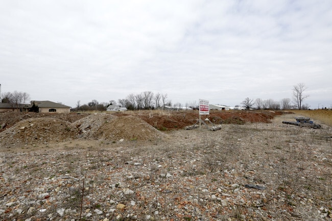
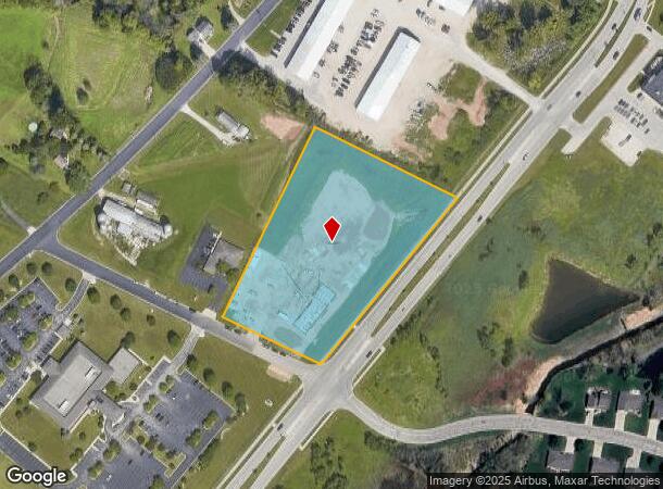
2233 Kaftan Way
Green Bay, WI
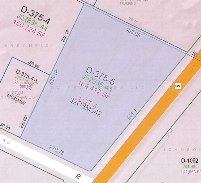
Cert Surv Map 5045
D-375-5
187,303 SQ FT LOT 4 OF 32 CSM 342 MAP 5045 IN 1469161 BNG PRT OF PC 35 ESFR EX RD IN 1831307 & PRT OF PC 34 ESFR AS DESC IN 2700467
Commercialnec
Brown
X
Wisconsin
55009C0267F
4
2024
4.30 AC
2024
Bellevue/De Pere
020702
Green Bay
DEMOGRAPHICS near 2233 Kaftan Way
1 mile
3 mile
5 mile
2024 Total Population
4,992
34,196
85,340
2029 Population
5,126
34,857
87,043
Pop Growth 2024-2029
+ 2.68%
+ 1.93%
+ 2.00%
Average Age
38
40
40
2024 Total Households
1,780
13,428
35,110
HH Growth 2024-2029
+ 2.70%
+ 2.02%
+ 2.09%
Median Household Inc
$113,983
$81,253
$66,321
Avg Household Size
2.80
2.40
2.30
2024 Avg HH Vehicles
2.00
2.00
2.00
Median Home Value
$334,276
$279,559
$234,804
Median Year Built
2001
1989
1983
Nearby Places
Map Layers
Map Styles
 Street
 Aerial
Transit
 Traffic
 Biking
Places
Listings with unknown addresses are not visible on the map
- Restaurants
- Banks
- Shops
- Fitness
- Groceries
PUBLIC TRANSPORTATION
AIRPORT
Green Bay/Austin Straubel International
Drive
Walk
Distance
Green Bay/Austin Straubel International
18 min
10.4 mi
Appleton International
Drive
Walk
Distance
Appleton International
48 min
36.7 mi
Freight Ports
Port Milwaukee
Drive
Walk
Distance
Port Milwaukee
132 min
115.0 mi
SALE & LEASE HISTORY
LISTING DATE
SALE/LEASE

Sep 24, 2016
For Sale
Jul 28, 2017
For Sale
Apr 18, 2017
For Sale
Nearby Properties
Address
Land Use
TOTAL SIZE
Lot Size
Zoning
Address
Land Use
TOTAL SIZE
Lot Size
Zoning
15.61 AC
Address
Land Use
TOTAL SIZE
Lot Size
Zoning
10.97 AC
Address
Land Use
TOTAL SIZE
Lot Size
Zoning
5.90 AC
Address
Land Use
TOTAL SIZE
Lot Size
Zoning
15.51 AC
Address
Land Use
TOTAL SIZE
Lot Size
Zoning
10.58 AC
Address
Land Use
TOTAL SIZE
Lot Size
Zoning
19.59 AC
Address
Land Use
TOTAL SIZE
Lot Size
Zoning
20.05 AC
Address
Land Use
TOTAL SIZE
Lot Size
Zoning
13.10 AC
Address
Land Use
TOTAL SIZE
Lot Size
Zoning
156,284 SF
13.76 AC
Address
Land Use
TOTAL SIZE
Lot Size
Zoning
18.13 AC
Address
Land Use
TOTAL SIZE
Lot Size
Zoning
8.87 AC
Address
Land Use
TOTAL SIZE
Lot Size
Zoning
13.76 AC
Address
Land Use
TOTAL SIZE
Lot Size
Zoning
13.30 AC
Address
Land Use
TOTAL SIZE
Lot Size
Zoning
170,188 SF
3.62 AC
Address
Land Use
TOTAL SIZE
Lot Size
Zoning
121,518 SF
7.03 AC
Address
Land Use
TOTAL SIZE
Lot Size
Zoning
6.16 AC
Address
Land Use
TOTAL SIZE
Lot Size
Zoning
225.80 AC
Address
Land Use
TOTAL SIZE
Lot Size
Zoning
39.22 AC
Address
Land Use
TOTAL SIZE
Lot Size
Zoning
13.54 AC
Address
Land Use
TOTAL SIZE
Lot Size
Zoning
13.78 AC
Address
Land Use
TOTAL SIZE
Lot Size
Zoning
70,312 SF
4.79 AC
Address
Land Use
TOTAL SIZE
Lot Size
Zoning
6.39 AC
Address
Land Use
TOTAL SIZE
Lot Size
Zoning
9.48 AC
Address
Land Use
TOTAL SIZE
Lot Size
Zoning
116,838 SF
6.30 AC
Address
Land Use
TOTAL SIZE
Lot Size
Zoning
35,330 SF
5.47 AC
Address
Land Use
TOTAL SIZE
Lot Size
Zoning
2.24 AC
Address
Land Use
TOTAL SIZE
Lot Size
Zoning
7.33 AC
Address
Land Use
TOTAL SIZE
Lot Size
Zoning
38,523 SF
0.27 AC
Address
Land Use
TOTAL SIZE
Lot Size
Zoning
Address
Land Use
TOTAL SIZE
Lot Size
Zoning
112,704 SF
6.85 AC
The World's #1 Commercial Real Estate Marketplace
Connect with us
© 2026 CoStar Group
The information above has been obtained from sources believed reliable. While we do not doubt its accuracy we have not verified it and make no guarantee, warranty or representation about it. It is your responsibility to independently confirm its accuracy and completeness. Any projections, opinions, assumptions, or estimates used are for example only and do not represent the current or future performance of the property. The value of this transaction to you depends on tax and other factors which should be evaluated by your tax, financial, and legal advisors. You and your advisors should conduct a careful, independent investigation of the property to determine to your satisfaction the suitability of the property for your needs.