Property Record
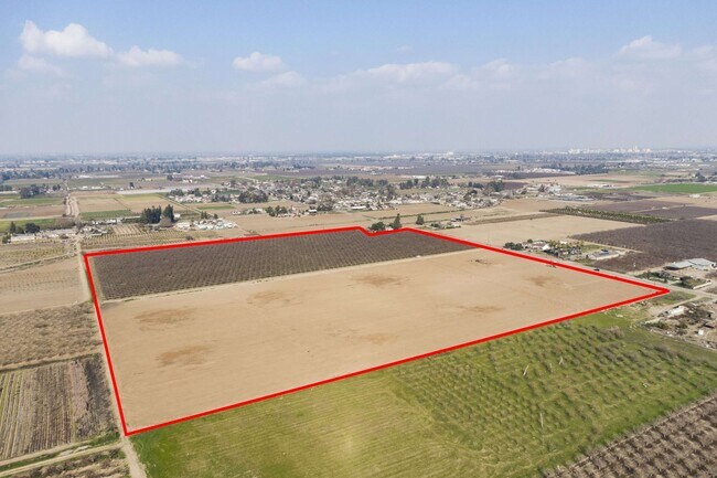
2233 S Valentine Ave, Fresno, CA 93706

NEARBY LISTINGS FOR SALE OR LEASE
Property Detail
2233 S Valentine Ave
Fresno, CA
Mount Diablo Base & Meridian
327-130-22
2233 S VALENTINE FR
Orchard
Fresno
X
California
06019C2105H
3
2025
20 AC
2025
W Outlying Fresno County
008600
Fresno
DEMOGRAPHICS near 2233 S Valentine Ave
1 Mile
3 Mile
5 Mile
2024 Total Population
1,097
10,842
85,082
2029 Population
1,109
10,994
86,481
Pop Growth 2024-2029
+ 1.09%
+ 1.40%
+ 1.64%
Average Age
37
36
35
2024 Total Households
302
3,174
25,123
HH Growth 2024-2029
+ 0.99%
+ 1.32%
+ 1.67%
Median Household Inc
$65,000
$38,482
$41,684
Avg Household Size
3.40
3.20
3.10
2024 Avg HH Vehicles
3.00
2.00
2.00
Median Home Value
$370,407
$254,505
$251,367
Median Year Built
1969
1967
1968
Nearby Places
Map Layers
Map Styles
 Street
 Aerial
- Restaurants
- Banks
- Shops
- Fitness
- Groceries
PUBLIC TRANSPORTATION
COMMUTER RAIL
Fresno (San Joaquins - Amtrak)
DRIVE
WALK
Distance
Fresno (San Joaquins - Amtrak)
12 min
8.1 mi
AIRPORT
Fresno Yosemite International
DRIVE
WALK
Distance
Fresno Yosemite International
18 min
11.4 mi
Freight Ports
Port of Stockton
DRIVE
WALK
Distance
Port of Stockton
157 min
129.1 mi
SALE & LEASE HISTORY
LISTING DATE
SALE/LEASE

Mar 08, 2022
For Sale
Nearby Properties
Address
Land Use
TOTAL SIZE
Lot Size
Zoning
Address
Land Use
TOTAL SIZE
Lot Size
Zoning
141,959 SF
35.39 AC
SPLIT
Address
Land Use
TOTAL SIZE
Lot Size
Zoning
61,575 SF
3.50 AC
SPLIT
Address
Land Use
TOTAL SIZE
Lot Size
Zoning
71,384 SF
6.34 AC
IL
Address
Land Use
TOTAL SIZE
Lot Size
Zoning
106,740 SF
63.59 AC
AE20
Address
Land Use
TOTAL SIZE
Lot Size
Zoning
23,616 SF
5.22 AC
SPLIT
Address
Land Use
TOTAL SIZE
Lot Size
Zoning
37,617 SF
4.77 AC
NMX
Address
Land Use
TOTAL SIZE
Lot Size
Zoning
62,612 SF
4.06 AC
RS5
Address
Land Use
TOTAL SIZE
Lot Size
Zoning
60,438 SF
11.46 AC
M1
Address
Land Use
TOTAL SIZE
Lot Size
Zoning
22.24 AC
M3
Address
Land Use
TOTAL SIZE
Lot Size
Zoning
7,020 SF
2.92 AC
M1
Address
Land Use
TOTAL SIZE
Lot Size
Zoning
17,960 SF
5.07 AC
M3
Address
Land Use
TOTAL SIZE
Lot Size
Zoning
2,048 SF
259 AC
AE20
Address
Land Use
TOTAL SIZE
Lot Size
Zoning
38,730 SF
5.39 AC
RM2
Address
Land Use
TOTAL SIZE
Lot Size
Zoning
30,482 SF
2.56 AC
R1C
Address
Land Use
TOTAL SIZE
Lot Size
Zoning
56,300 SF
4.76 AC
M3
Address
Land Use
TOTAL SIZE
Lot Size
Zoning
30,160 SF
1.33 AC
RS5
Address
Land Use
TOTAL SIZE
Lot Size
Zoning
15.03 AC
M2
Address
Land Use
TOTAL SIZE
Lot Size
Zoning
84,624 SF
7.20 AC
R2
Address
Land Use
TOTAL SIZE
Lot Size
Zoning
5,721 SF
39.52 AC
AE20
Address
Land Use
TOTAL SIZE
Lot Size
Zoning
274.95 AC
AE20
Address
Land Use
TOTAL SIZE
Lot Size
Zoning
16,720 SF
12.46 AC
M1
Address
Land Use
TOTAL SIZE
Lot Size
Zoning
8,163 SF
30.51 AC
AE20
Address
Land Use
TOTAL SIZE
Lot Size
Zoning
4,593 SF
19.55 AC
AE20
Address
Land Use
TOTAL SIZE
Lot Size
Zoning
8,320 SF
0.80 AC
NMX
Address
Land Use
TOTAL SIZE
Lot Size
Zoning
20,594 SF
4.70 AC
M2
Address
Land Use
TOTAL SIZE
Lot Size
Zoning
7,320 SF
7.43 AC
CH
Address
Land Use
TOTAL SIZE
Lot Size
Zoning
67.47 AC
R1
Address
Land Use
TOTAL SIZE
Lot Size
Zoning
1,104 SF
38.20 AC
AE20
Address
Land Use
TOTAL SIZE
Lot Size
Zoning
15,222 SF
26.92 AC
M2
Address
Land Use
TOTAL SIZE
Lot Size
Zoning
26.89 AC
M3
The World's #1 Commercial Real Estate Marketplace
Connect with us
© 2025 CoStar Group
The information above has been obtained from sources believed reliable. While we do not doubt its accuracy we have not verified it and make no guarantee, warranty or representation about it. It is your responsibility to independently confirm its accuracy and completeness. Any projections, opinions, assumptions, or estimates used are for example only and do not represent the current or future performance of the property. The value of this transaction to you depends on tax and other factors which should be evaluated by your tax, financial, and legal advisors. You and your advisors should conduct a careful, independent investigation of the property to determine to your satisfaction the suitability of the property for your needs.