Property Record
22331 Fm 529 Rd, Cypress, TX 77433
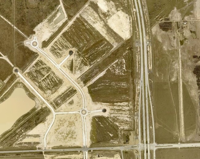

Property Detail
22331 Fm 529 Rd
Houston-Pasadena-The Woodlands, TX
TRS 1A 1A-1 1A-2 1A-2H 1A-2I 1A-3 1A-3C 1A-9 & 1A-11 & 1A-12 ABST 1388 H&TCRR SEC 30 BLK 2
0471600000012
HARRIS
Outdoorrecreationbeachmountaindesert
Texas
2024
330.19 AC
2025
Northwest Outlier
543004
Houston
2,939 SF
NEARBY LISTINGS FOR SALE OR LEASE
DEMOGRAPHICS near 22331 Fm 529 Rd
1 mile
3 mile
5 mile
2024 Total Population
276
58,772
219,027
2029 Population
293
61,432
227,467
Pop Growth 2024-2029
+ 6.16%
+ 4.53%
+ 3.85%
Average Age
34
33
33
2024 Total Households
84
17,022
64,244
HH Growth 2024-2029
+ 5.95%
+ 4.53%
+ 3.82%
Median Household Inc
$104,348
$88,138
$95,608
Avg Household Size
3.30
3.40
3.30
2024 Avg HH Vehicles
2.00
2.00
2.00
Median Home Value
$188,157
$235,941
$246,943
Median Year Built
2009
2010
2010
Nearby Places
Map Layers
Map Styles
 Street
 Aerial
Transit
 Traffic
 Biking
Places
Listings with unknown addresses are not visible on the map
- Restaurants
- Banks
- Shops
- Fitness
- Groceries
PUBLIC TRANSPORTATION
AIRPORT
George Bush Intcntl/Houston
Drive
Walk
Distance
George Bush Intcntl/Houston
47 min
31.6 mi
Freight Ports
Port of Houston
Drive
Walk
Distance
Port of Houston
58 min
37.9 mi
Nearby Properties
Address
Land Use
TOTAL SIZE
Lot Size
Zoning
Address
Land Use
TOTAL SIZE
Lot Size
Zoning
851,991 SF
229.30 AC
Address
Land Use
TOTAL SIZE
Lot Size
Zoning
838,700 SF
36.68 AC
Address
Land Use
TOTAL SIZE
Lot Size
Zoning
355,721 SF
13 AC
Address
Land Use
TOTAL SIZE
Lot Size
Zoning
323,609 SF
12.71 AC
Address
Land Use
TOTAL SIZE
Lot Size
Zoning
267,766 SF
12.96 AC
Address
Land Use
TOTAL SIZE
Lot Size
Zoning
290,927 SF
14.53 AC
Address
Land Use
TOTAL SIZE
Lot Size
Zoning
147,923 SF
11.60 AC
Address
Land Use
TOTAL SIZE
Lot Size
Zoning
117,860 SF
12.44 AC
Address
Land Use
TOTAL SIZE
Lot Size
Zoning
191,575 SF
17.98 AC
Address
Land Use
TOTAL SIZE
Lot Size
Zoning
122,880 SF
15 AC
Address
Land Use
TOTAL SIZE
Lot Size
Zoning
99,096 SF
27.51 AC
Address
Land Use
TOTAL SIZE
Lot Size
Zoning
201,809 SF
21.18 AC
Address
Land Use
TOTAL SIZE
Lot Size
Zoning
129,510 SF
18.51 AC
Address
Land Use
TOTAL SIZE
Lot Size
Zoning
67,250 SF
7.37 AC
Address
Land Use
TOTAL SIZE
Lot Size
Zoning
84.23 AC
Address
Land Use
TOTAL SIZE
Lot Size
Zoning
245.16 AC
Address
Land Use
TOTAL SIZE
Lot Size
Zoning
57,453 SF
6.74 AC
Address
Land Use
TOTAL SIZE
Lot Size
Zoning
105,500 SF
5.49 AC
Address
Land Use
TOTAL SIZE
Lot Size
Zoning
156.37 AC
Address
Land Use
TOTAL SIZE
Lot Size
Zoning
67,312 SF
6.95 AC
Address
Land Use
TOTAL SIZE
Lot Size
Zoning
11,431 SF
4.60 AC
Address
Land Use
TOTAL SIZE
Lot Size
Zoning
124,290 SF
5.85 AC
Address
Land Use
TOTAL SIZE
Lot Size
Zoning
136.37 AC
Address
Land Use
TOTAL SIZE
Lot Size
Zoning
22,620 SF
7.55 AC
Address
Land Use
TOTAL SIZE
Lot Size
Zoning
168.70 AC
Address
Land Use
TOTAL SIZE
Lot Size
Zoning
329,931 SF
209.45 AC
Address
Land Use
TOTAL SIZE
Lot Size
Zoning
12.01 AC
Address
Land Use
TOTAL SIZE
Lot Size
Zoning
103,147 SF
7 AC
Address
Land Use
TOTAL SIZE
Lot Size
Zoning
21,600 SF
5.69 AC
The World's #1 Commercial Real Estate Marketplace
Connect with us
© 2026 CoStar Group
The information above has been obtained from sources believed reliable. While we do not doubt its accuracy we have not verified it and make no guarantee, warranty or representation about it. It is your responsibility to independently confirm its accuracy and completeness. Any projections, opinions, assumptions, or estimates used are for example only and do not represent the current or future performance of the property. The value of this transaction to you depends on tax and other factors which should be evaluated by your tax, financial, and legal advisors. You and your advisors should conduct a careful, independent investigation of the property to determine to your satisfaction the suitability of the property for your needs.