Property Record
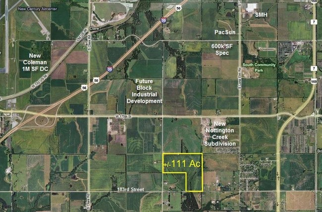
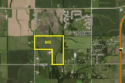
22340 W 183Rd St, Spring Hill, KS 66083

Property Detail
22340 W 183Rd St
9F231427-2007
27-14-23 PT SW1/4 BG 20 N SE CR SW1/4 W 555.50 N 20 W 300 S 20 W 165.27 N 1294.76 W 1656.64 TO PT 20 E W/L SW1/4 N 1317.81 E ALG N/L 1/4 2664.89 TO NE CR S 2605.79 TO POB EX .07 AC IN ST & EX .256 AC IN ST 108.454 ACS M/L SP 28 1C 5
Farms
JOHNSON
RUR
Kansas
AE The base floodplain where base flood elevations are provided. AE Zones are now used on new format FIRMs instead of A1-A30 Zones.
110.39 AC
2025
South Johnson County
2025
Kansas City
053801
Kansas City, MO-KS
NEARBY LISTINGS FOR SALE OR LEASE
DEMOGRAPHICS near 22340 W 183Rd St
1 mile
3 mile
5 mile
2025 Total Population
1,250
6,945
60,294
2030 Population
1,288
7,304
62,837
Pop Growth 2025-2030
+ 3.04%
+ 5.17%
+ 4.22%
Average Age
40
38
37
2025 Total Households
441
2,240
20,365
HH Growth 2025-2030
+ 3.17%
+ 5.67%
+ 4.44%
Median Household Inc
$102,941
$93,865
$109,226
Avg Household Size
2.80
2.80
2.90
2025 Avg HH Vehicles
2.00
2.00
2.00
Median Home Value
$418,182
$356,308
$356,535
Median Year Built
1988
2000
2001
Nearby Places
Map Layers
Map Styles
 Street
 Aerial
Layers
 Traffic
 Biking
Places
Listings with unknown addresses are not visible on the map
- Restaurants
- Banks
- Shops
- Fitness
- Groceries
SALE & LEASE HISTORY
LISTING DATE
SALE/LEASE

Sep 24, 2016
For Sale
Nearby Properties
Address
Land Use
TOTAL SIZE
Lot Size
Zoning
Address
Land Use
TOTAL SIZE
Lot Size
Zoning
1,060,732 SF
57.62 AC
MP-2
Address
Land Use
TOTAL SIZE
Lot Size
Zoning
71,086 SF
22.76 AC
R-3
Address
Land Use
TOTAL SIZE
Lot Size
Zoning
720,320 SF
39.19 AC
MP-2
Address
Land Use
TOTAL SIZE
Lot Size
Zoning
746,120 SF
PEC3
Address
Land Use
TOTAL SIZE
Lot Size
Zoning
648,070 SF
33.46 AC
MP-1
Address
Land Use
TOTAL SIZE
Lot Size
Zoning
508,664 SF
29.46 AC
MP-2
Address
Land Use
TOTAL SIZE
Lot Size
Zoning
320,835 SF
57.95 AC
M-2
Address
Land Use
TOTAL SIZE
Lot Size
Zoning
499,084 SF
28.99 AC
RUR
Address
Land Use
TOTAL SIZE
Lot Size
Zoning
236,108 SF
12.38 AC
R-1
Address
Land Use
TOTAL SIZE
Lot Size
Zoning
102,280 SF
30.53 AC
RP-4
Address
Land Use
TOTAL SIZE
Lot Size
Zoning
70,643 SF
18.45 AC
RP-1
Address
Land Use
TOTAL SIZE
Lot Size
Zoning
331,712 SF
PEC3
Address
Land Use
TOTAL SIZE
Lot Size
Zoning
1,107,600 SF
50.97 AC
MP-1
Address
Land Use
TOTAL SIZE
Lot Size
Zoning
75,560 SF
32.62 AC
CTY RUR
Address
Land Use
TOTAL SIZE
Lot Size
Zoning
320,891 SF
39.07 AC
M-2
Address
Land Use
TOTAL SIZE
Lot Size
Zoning
244,992 SF
15.75 AC
MP-2
Address
Land Use
TOTAL SIZE
Lot Size
Zoning
212,032 SF
9.53 AC
RUR
Address
Land Use
TOTAL SIZE
Lot Size
Zoning
137,532 SF
12.02 AC
M-2
Address
Land Use
TOTAL SIZE
Lot Size
Zoning
127,880 SF
5.77 AC
M-2
Address
Land Use
TOTAL SIZE
Lot Size
Zoning
688,460 SF
116.12 AC
MP-2
Address
Land Use
TOTAL SIZE
Lot Size
Zoning
601,670 SF
37.16 AC
MP-2
Address
Land Use
TOTAL SIZE
Lot Size
Zoning
10,956 SF
90 AC
PEC3
Address
Land Use
TOTAL SIZE
Lot Size
Zoning
418,969 SF
48.14 AC
M-2
Address
Land Use
TOTAL SIZE
Lot Size
Zoning
446,772 SF
28.49 AC
MP-2
Address
Land Use
TOTAL SIZE
Lot Size
Zoning
30,994 SF
3.47 AC
C-3
Address
Land Use
TOTAL SIZE
Lot Size
Zoning
436,174 SF
22.56 AC
MP-2
Address
Land Use
TOTAL SIZE
Lot Size
Zoning
533,662 SF
24.67 AC
MP-2
Address
Land Use
TOTAL SIZE
Lot Size
Zoning
41,250 SF
6.01 AC
R-R
Address
Land Use
TOTAL SIZE
Lot Size
Zoning
56,252 SF
77.39 AC
AG
The World's #1 Commercial Real Estate Marketplace
Connect with us
© 2026 CoStar Group
The information above has been obtained from sources believed reliable. While we do not doubt its accuracy we have not verified it and make no guarantee, warranty or representation about it. It is your responsibility to independently confirm its accuracy and completeness. Any projections, opinions, assumptions, or estimates used are for example only and do not represent the current or future performance of the property. The value of this transaction to you depends on tax and other factors which should be evaluated by your tax, financial, and legal advisors. You and your advisors should conduct a careful, independent investigation of the property to determine to your satisfaction the suitability of the property for your needs.