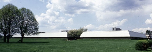
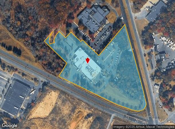
Property Record
2235 Us Highway 130 Rte, Dayton, NJ 08810
NEARBY LISTINGS FOR SALE OR LEASE
Property Detail
2235 Us Highway 130 Rte
New York-Jersey City-White Plains, NY-NJ
11.165 AC
21-00031-02-00034-0821
Middlesex
Vacantlandnec
New Jersey
X
34.82
34023C0119F
11.17 AC
2024
Exit 8A
2025
Northern New Jersey
008505
DEMOGRAPHICS near 2235 Us Highway 130 Rte
1 Mile
3 Mile
5 Mile
2024 Total Population
6,404
26,348
127,174
2029 Population
6,419
26,407
126,723
Pop Growth 2024-2029
+ 0.23%
+ 0.22%
(0.35%)
Average Age
39
39
41
2024 Total Households
2,086
8,849
46,888
HH Growth 2024-2029
+ 0.24%
+ 0.18%
(0.52%)
Median Household Inc
$136,950
$122,255
$116,919
Avg Household Size
3.00
2.90
2.70
2024 Avg HH Vehicles
2.00
2.00
2.00
Median Home Value
$435,343
$471,380
$460,712
Median Year Built
1990
1990
1986
Nearby Places
Map Layers
Map Styles
 Street
 Aerial
- Restaurants
- Banks
- Shops
- Fitness
- Groceries
PUBLIC TRANSPORTATION
COMMUTER RAIL
Jersey Avenue (Northeast Corridor Line - NJ Transit Commuter Rail (NJ Transit))
DRIVE
WALK
Distance
Jersey Avenue (Northeast Corridor Line - NJ Transit Commuter Rail (NJ Transit))
21 min
8.6 mi
New Brunswick (Northeast Corridor Line - NJ Transit Commuter Rail (NJ Transit))
DRIVE
WALK
Distance
New Brunswick (Northeast Corridor Line - NJ Transit Commuter Rail (NJ Transit))
20 min
9.9 mi
AIRPORT
Trenton Mercer
DRIVE
WALK
Distance
Trenton Mercer
33 min
21.8 mi
Newark Liberty International
DRIVE
WALK
Distance
Newark Liberty International
49 min
36.0 mi
Freight Ports
New York Container Terminal
DRIVE
WALK
Distance
New York Container Terminal
43 min
28.8 mi
Nearby Properties
Address
Land Use
TOTAL SIZE
Lot Size
Zoning
Address
Land Use
TOTAL SIZE
Lot Size
Zoning
161,447 SF
67.62 AC
R30
Address
Land Use
TOTAL SIZE
Lot Size
Zoning
212.16 AC
I-3
Address
Land Use
TOTAL SIZE
Lot Size
Zoning
42.10 AC
LI5
Address
Land Use
TOTAL SIZE
Lot Size
Zoning
1,145,608 SF
73.19 AC
LI
Address
Land Use
TOTAL SIZE
Lot Size
Zoning
80.34 AC
LI5
Address
Land Use
TOTAL SIZE
Lot Size
Zoning
983,940 SF
62.53 AC
LI
Address
Land Use
TOTAL SIZE
Lot Size
Zoning
103.93 AC
ERR
Address
Land Use
TOTAL SIZE
Lot Size
Zoning
87.65 AC
LI-4
Address
Land Use
TOTAL SIZE
Lot Size
Zoning
0.46 AC
AH
Address
Land Use
TOTAL SIZE
Lot Size
Zoning
28,155 SF
90.95 AC
I3R4
Address
Land Use
TOTAL SIZE
Lot Size
Zoning
72.62 AC
PL
Address
Land Use
TOTAL SIZE
Lot Size
Zoning
29.74 AC
R30
Address
Land Use
TOTAL SIZE
Lot Size
Zoning
79.67 AC
I-3
Address
Land Use
TOTAL SIZE
Lot Size
Zoning
50.73 AC
I-3
Address
Land Use
TOTAL SIZE
Lot Size
Zoning
18.93 AC
R30
Address
Land Use
TOTAL SIZE
Lot Size
Zoning
44.80 AC
LI-4
Address
Land Use
TOTAL SIZE
Lot Size
Zoning
49.12 AC
LI-4
Address
Land Use
TOTAL SIZE
Lot Size
Zoning
3,555 SF
25.73 AC
PL
Address
Land Use
TOTAL SIZE
Lot Size
Zoning
17.13 AC
PUD2
Address
Land Use
TOTAL SIZE
Lot Size
Zoning
299,532 SF
22.35 AC
LI
Address
Land Use
TOTAL SIZE
Lot Size
Zoning
50.34 AC
I-3
Address
Land Use
TOTAL SIZE
Lot Size
Zoning
626,675 SF
54.07 AC
LI-2
Address
Land Use
TOTAL SIZE
Lot Size
Zoning
43.90 AC
I-3
Address
Land Use
TOTAL SIZE
Lot Size
Zoning
227,175 SF
16.43 AC
LI
Address
Land Use
TOTAL SIZE
Lot Size
Zoning
36.59 AC
I-3
Address
Land Use
TOTAL SIZE
Lot Size
Zoning
23.58 AC
PL
Address
Land Use
TOTAL SIZE
Lot Size
Zoning
34.53 AC
I-3
Address
Land Use
TOTAL SIZE
Lot Size
Zoning
610,949 SF
39.46 AC
I-3
Address
Land Use
TOTAL SIZE
Lot Size
Zoning
21.81 AC
PL
Address
Land Use
TOTAL SIZE
Lot Size
Zoning
521,794 SF
34.63 AC
I-3
The World's #1 Commercial Real Estate Marketplace
Connect with us
© 2025 CoStar Group
The information above has been obtained from sources believed reliable. While we do not doubt its accuracy we have not verified it and make no guarantee, warranty or representation about it. It is your responsibility to independently confirm its accuracy and completeness. Any projections, opinions, assumptions, or estimates used are for example only and do not represent the current or future performance of the property. The value of this transaction to you depends on tax and other factors which should be evaluated by your tax, financial, and legal advisors. You and your advisors should conduct a careful, independent investigation of the property to determine to your satisfaction the suitability of the property for your needs.