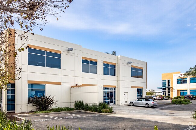
Property Record
2245 W 190Th St, Torrance, CA 90504


Current Lease Availabilities
NEARBY LISTINGS FOR SALE OR LEASE
Property Detail
2245 W 190Th St
Los Angeles-Long Beach-Glendale, CA
54148
4090-025-032
TR=54148 LOT 5 CONDO UNIT 5 M (AIRSPACE AND 1/2 INT IN COMMON AREA)
Officecondo
Los Angeles
X
California
06037C1930F
5
2024
0.19 AC
2025
190th Street Corridor
650200
Los Angeles
5,304 SF
DEMOGRAPHICS near 2245 W 190Th St
1 Mile
3 Mile
5 Mile
2024 Total Population
9,944
224,744
644,652
2029 Population
9,618
217,849
625,526
Pop Growth 2024-2029
(3.28%)
(3.07%)
(2.97%)
Average Age
44
41
41
2024 Total Households
3,471
78,545
224,101
HH Growth 2024-2029
(3.54%)
(3.30%)
(3.14%)
Median Household Inc
$108,323
$85,657
$91,231
Avg Household Size
2.80
2.70
2.80
2024 Avg HH Vehicles
2.00
2.00
2.00
Median Home Value
$755,691
$751,958
$796,961
Median Year Built
1956
1963
1964
Nearby Places
- Restaurants
- Banks
- Shops
- Fitness
- Groceries
PUBLIC TRANSPORTATION
AIRPORT
Los Angeles International
DRIVE
WALK
Distance
Los Angeles International
15 min
10.4 mi
Long Beach (Daugherty Field)
DRIVE
WALK
Distance
Long Beach (Daugherty Field)
14 min
11.5 mi
John Wayne/Orange County
DRIVE
WALK
Distance
John Wayne/Orange County
32 min
30.9 mi
Freight Ports
Port of Los Angeles
DRIVE
WALK
Distance
Port of Los Angeles
1 min
9.0 mi
Nearby Properties
Address
Land Use
TOTAL SIZE
Lot Size
Zoning
Address
Land Use
TOTAL SIZE
Lot Size
Zoning
997,143 SF
98.35 AC
TOMI-BP
Address
Land Use
TOTAL SIZE
Lot Size
Zoning
267,305 SF
1.59 AC
TOHC-CTR
Address
Land Use
TOTAL SIZE
Lot Size
Zoning
64,456 SF
11.71 AC
CASP-10*
Address
Land Use
TOTAL SIZE
Lot Size
Zoning
10,152 SF
140.14 AC
TOMI-HVY
Address
Land Use
TOTAL SIZE
Lot Size
Zoning
422,640 SF
LAM3
Address
Land Use
TOTAL SIZE
Lot Size
Zoning
267,131 SF
12.10 AC
TOHHM
Address
Land Use
TOTAL SIZE
Lot Size
Zoning
321,011 SF
15.06 AC
TOMI-LT
Address
Land Use
TOTAL SIZE
Lot Size
Zoning
297,420 SF
6.65 AC
TOHC-CTR
Address
Land Use
TOTAL SIZE
Lot Size
Zoning
604,106 SF
42.72 AC
TOMI-HVY
Address
Land Use
TOTAL SIZE
Lot Size
Zoning
506,189 SF
20.33 AC
LAM2
Address
Land Use
TOTAL SIZE
Lot Size
Zoning
849,570 SF
36.76 AC
LAM3
Address
Land Use
TOTAL SIZE
Lot Size
Zoning
1,504,661 SF
RBCR
Address
Land Use
TOTAL SIZE
Lot Size
Zoning
3,585,714 SF
67.35 AC
LAM3
Address
Land Use
TOTAL SIZE
Lot Size
Zoning
409,522 SF
11.41 AC
LAM3
Address
Land Use
TOTAL SIZE
Lot Size
Zoning
202,924 SF
6.15 AC
TOHC-CTR
Address
Land Use
TOTAL SIZE
Lot Size
Zoning
184,300 SF
8.14 AC
LAM3
Address
Land Use
TOTAL SIZE
Lot Size
Zoning
214,782 SF
3.66 AC
GAR3
Address
Land Use
TOTAL SIZE
Lot Size
Zoning
405,352 SF
7.70 AC
TOHC-CTR
Address
Land Use
TOTAL SIZE
Lot Size
Zoning
103,228 SF
1.19 AC
TORR-HI
Address
Land Use
TOTAL SIZE
Lot Size
Zoning
260,766 SF
10.70 AC
LAM3
Address
Land Use
TOTAL SIZE
Lot Size
Zoning
502,236 SF
11.58 AC
TOMI-LT
Address
Land Use
TOTAL SIZE
Lot Size
Zoning
429,141 SF
3.29 AC
LCM1*
Address
Land Use
TOTAL SIZE
Lot Size
Zoning
282,280 SF
Address
Land Use
TOTAL SIZE
Lot Size
Zoning
176,514 SF
3.74 AC
TORR-MH
Address
Land Use
TOTAL SIZE
Lot Size
Zoning
670,305 SF
28.08 AC
TOMI-BP
Address
Land Use
TOTAL SIZE
Lot Size
Zoning
198,502 SF
LCM2 *
The World's #1 Commercial Real Estate Marketplace
Connect with us
© 2025 CoStar Group
The information above has been obtained from sources believed reliable. While we do not doubt its accuracy we have not verified it and make no guarantee, warranty or representation about it. It is your responsibility to independently confirm its accuracy and completeness. Any projections, opinions, assumptions, or estimates used are for example only and do not represent the current or future performance of the property. The value of this transaction to you depends on tax and other factors which should be evaluated by your tax, financial, and legal advisors. You and your advisors should conduct a careful, independent investigation of the property to determine to your satisfaction the suitability of the property for your needs.