Property Record
224 Investment Loop, Hutto, TX 78634
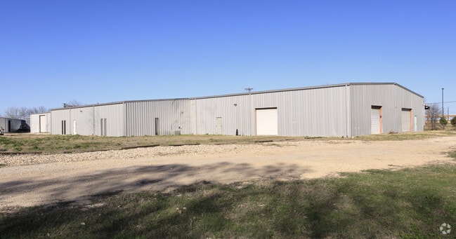


Property Detail
224 Investment Loop
Austin-Round Rock-San Marcos, TX
S3009 - 79 BUSINESS PARK, BLOCK A, LOT 32-34, ACRES 2.25
R082567
Williamson
Industrialgeneral
Texas
AE The base floodplain where base flood elevations are provided. AE Zones are now used on new format FIRMs instead of A1-A30 Zones.
32-34
2024
2.25 AC
2025
Georgetown
020817
Austin
37,032 SF
NEARBY LISTINGS FOR SALE OR LEASE
-
-
-
-
-
-
SE Corner of Innovation Blvd. and Limmer loop
Hutto, TX 78634
Rent Upon Request
102,060 SF
Industrial
-
-
View all Hutto listings for lease on LoopNet.com
DEMOGRAPHICS near 224 Investment Loop
1 mile
3 mile
5 mile
2024 Total Population
4,065
76,985
158,282
2029 Population
4,671
88,356
179,374
Pop Growth 2024-2029
+ 14.91%
+ 14.77%
+ 13.33%
Average Age
35
36
36
2024 Total Households
1,379
25,040
52,663
HH Growth 2024-2029
+ 15.45%
+ 15.21%
+ 13.84%
Median Household Inc
$131,451
$130,829
$126,996
Avg Household Size
2.90
3.00
3.00
2024 Avg HH Vehicles
2.00
2.00
2.00
Median Home Value
$455,769
$440,845
$445,716
Median Year Built
2011
2010
2010
Nearby Places
Map Layers
Map Styles
 Street
 Aerial
Transit
 Traffic
 Biking
Places
Listings with unknown addresses are not visible on the map
- Restaurants
- Banks
- Shops
- Fitness
- Groceries
PUBLIC TRANSPORTATION
AIRPORT
Austin-Bergstrom International
Drive
Walk
Distance
Austin-Bergstrom International
42 min
33.2 mi
SALE & LEASE HISTORY
LISTING DATE
SALE/LEASE

Sep 25, 2016
For Lease
Nov 05, 2019
For Lease
Dec 04, 2024
For Lease
Aug 16, 2021
For Lease
Aug 08, 2017
For Lease
Nearby Properties
Address
Land Use
TOTAL SIZE
Lot Size
Zoning
Address
Land Use
TOTAL SIZE
Lot Size
Zoning
533,782 SF
79.41 AC
Address
Land Use
TOTAL SIZE
Lot Size
Zoning
425,891 SF
20.85 AC
Address
Land Use
TOTAL SIZE
Lot Size
Zoning
409,416 SF
22.65 AC
Address
Land Use
TOTAL SIZE
Lot Size
Zoning
336,672 SF
15.09 AC
Address
Land Use
TOTAL SIZE
Lot Size
Zoning
302,465 SF
15.79 AC
Address
Land Use
TOTAL SIZE
Lot Size
Zoning
331,584 SF
21.09 AC
Address
Land Use
TOTAL SIZE
Lot Size
Zoning
315,884 SF
15.05 AC
Address
Land Use
TOTAL SIZE
Lot Size
Zoning
253,225 SF
12.25 AC
Address
Land Use
TOTAL SIZE
Lot Size
Zoning
301,721 SF
16.54 AC
Address
Land Use
TOTAL SIZE
Lot Size
Zoning
304,814 SF
17.04 AC
Address
Land Use
TOTAL SIZE
Lot Size
Zoning
308,759 SF
13.93 AC
Address
Land Use
TOTAL SIZE
Lot Size
Zoning
290,840 SF
20.08 AC
Address
Land Use
TOTAL SIZE
Lot Size
Zoning
165,534 SF
26.91 AC
Address
Land Use
TOTAL SIZE
Lot Size
Zoning
76.14 AC
Address
Land Use
TOTAL SIZE
Lot Size
Zoning
230,841 SF
17.51 AC
Address
Land Use
TOTAL SIZE
Lot Size
Zoning
183,310 SF
10.78 AC
Address
Land Use
TOTAL SIZE
Lot Size
Zoning
123,325 SF
14.13 AC
SF2
Address
Land Use
TOTAL SIZE
Lot Size
Zoning
8,640 SF
30.11 AC
RREXP
Address
Land Use
TOTAL SIZE
Lot Size
Zoning
338,229 SF
15.38 AC
Address
Land Use
TOTAL SIZE
Lot Size
Zoning
160,070 SF
13.68 AC
Address
Land Use
TOTAL SIZE
Lot Size
Zoning
195,520 SF
14.89 AC
Address
Land Use
TOTAL SIZE
Lot Size
Zoning
154,528 SF
7.23 AC
Address
Land Use
TOTAL SIZE
Lot Size
Zoning
220,850 SF
12.06 AC
Address
Land Use
TOTAL SIZE
Lot Size
Zoning
161,190 SF
8.82 AC
Address
Land Use
TOTAL SIZE
Lot Size
Zoning
215,475 SF
21.31 AC
PUD
Address
Land Use
TOTAL SIZE
Lot Size
Zoning
297,577 SF
28.22 AC
Address
Land Use
TOTAL SIZE
Lot Size
Zoning
141,718 SF
24.12 AC
Address
Land Use
TOTAL SIZE
Lot Size
Zoning
535,408 SF
30.16 AC
Address
Land Use
TOTAL SIZE
Lot Size
Zoning
7,000 SF
94.53 AC
LI
Address
Land Use
TOTAL SIZE
Lot Size
Zoning
The World's #1 Commercial Real Estate Marketplace
Connect with us
© 2026 CoStar Group
The information above has been obtained from sources believed reliable. While we do not doubt its accuracy we have not verified it and make no guarantee, warranty or representation about it. It is your responsibility to independently confirm its accuracy and completeness. Any projections, opinions, assumptions, or estimates used are for example only and do not represent the current or future performance of the property. The value of this transaction to you depends on tax and other factors which should be evaluated by your tax, financial, and legal advisors. You and your advisors should conduct a careful, independent investigation of the property to determine to your satisfaction the suitability of the property for your needs.