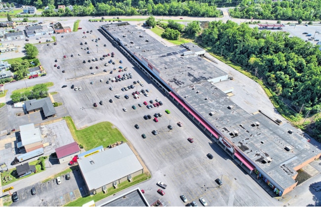
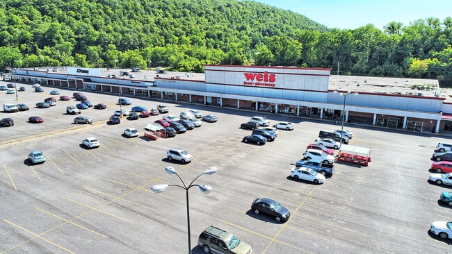
Property Record
224 N Logan Blvd, Burnham, PA 17009

NEARBY LISTINGS FOR SALE OR LEASE
Property Detail
224 N Logan Blvd
Commercialofficeresidentialmixeduse
Mifflin
AE
Pennsylvania
42087C0164C
22.09 AC
2025
Pennsylvania Central Area
2025
Other Market Areas
961102
Lewistown, PA
496,040 SF
16-04-0105P-000
DEMOGRAPHICS near 224 N Logan Blvd
1 Mile
3 Mile
5 Mile
2024 Total Population
4,190
18,221
25,606
2029 Population
4,195
18,285
25,644
Pop Growth 2024-2029
+ 0.12%
+ 0.35%
+ 0.15%
Average Age
44
43
43
2024 Total Households
1,766
7,906
10,936
HH Growth 2024-2029
+ 0.06%
+ 0.33%
+ 0.15%
Median Household Inc
$56,218
$51,300
$53,277
Avg Household Size
2.30
2.20
2.30
2024 Avg HH Vehicles
2.00
2.00
2.00
Median Home Value
$110,878
$97,285
$112,872
Median Year Built
1959
1952
1955
Nearby Places
Map Layers
Map Styles
 Street
 Aerial
- Restaurants
- Banks
- Shops
- Fitness
- Groceries
PUBLIC TRANSPORTATION
COMMUTER RAIL
Lewistown Amtrak Station (Pennsylvanian - Amtrak)
DRIVE
WALK
Distance
Lewistown Amtrak Station (Pennsylvanian - Amtrak)
9 min
3.9 mi
AIRPORT
State College Regional
DRIVE
WALK
Distance
State College Regional
52 min
32.9 mi
Freight Ports
Port of Baltimore
DRIVE
WALK
Distance
Port of Baltimore
187 min
141.2 mi
SALE & LEASE HISTORY
LISTING DATE
SALE/LEASE

Sep 25, 2016
For Lease
Nov 12, 2018
For Sale
Nov 11, 2019
For Sale
Mar 08, 2022
For Sale
Mar 06, 2019
For Sale
Feb 20, 2024
For Lease
Feb 12, 2019
For Sale
Aug 08, 2019
For Lease
Nearby Properties
Address
Land Use
TOTAL SIZE
Lot Size
Zoning
Address
Land Use
TOTAL SIZE
Lot Size
Zoning
281,058 SF
28.67 AC
Address
Land Use
TOTAL SIZE
Lot Size
Zoning
199,908 SF
5.93 AC
Address
Land Use
TOTAL SIZE
Lot Size
Zoning
160,175 SF
6 AC
Address
Land Use
TOTAL SIZE
Lot Size
Zoning
368,026 SF
25.36 AC
Address
Land Use
TOTAL SIZE
Lot Size
Zoning
206,900 SF
6.79 AC
Address
Land Use
TOTAL SIZE
Lot Size
Zoning
20.57 AC
Address
Land Use
TOTAL SIZE
Lot Size
Zoning
454,110 SF
20.74 AC
Address
Land Use
TOTAL SIZE
Lot Size
Zoning
84,030 SF
80.98 AC
Address
Land Use
TOTAL SIZE
Lot Size
Zoning
72,218 SF
3.55 AC
Address
Land Use
TOTAL SIZE
Lot Size
Zoning
124,338 SF
3.84 AC
Address
Land Use
TOTAL SIZE
Lot Size
Zoning
58,584 SF
4.33 AC
Address
Land Use
TOTAL SIZE
Lot Size
Zoning
37,430 SF
0.41 AC
Address
Land Use
TOTAL SIZE
Lot Size
Zoning
27,078 SF
0.88 AC
Address
Land Use
TOTAL SIZE
Lot Size
Zoning
171,186 SF
20.50 AC
Address
Land Use
TOTAL SIZE
Lot Size
Zoning
72,405 SF
0.69 AC
Address
Land Use
TOTAL SIZE
Lot Size
Zoning
18.56 AC
Address
Land Use
TOTAL SIZE
Lot Size
Zoning
43 AC
Address
Land Use
TOTAL SIZE
Lot Size
Zoning
Address
Land Use
TOTAL SIZE
Lot Size
Zoning
103,542 SF
10.34 AC
Address
Land Use
TOTAL SIZE
Lot Size
Zoning
41,338 SF
1.99 AC
Address
Land Use
TOTAL SIZE
Lot Size
Zoning
44,606 SF
5.21 AC
Address
Land Use
TOTAL SIZE
Lot Size
Zoning
11,214 SF
0.50 AC
Address
Land Use
TOTAL SIZE
Lot Size
Zoning
22,542 SF
3.20 AC
Address
Land Use
TOTAL SIZE
Lot Size
Zoning
32,606 SF
2.02 AC
Address
Land Use
TOTAL SIZE
Lot Size
Zoning
38,457 SF
3.35 AC
Address
Land Use
TOTAL SIZE
Lot Size
Zoning
64,822 SF
4.38 AC
Address
Land Use
TOTAL SIZE
Lot Size
Zoning
41,083 SF
2.56 AC
The World's #1 Commercial Real Estate Marketplace
Connect with us
© 2025 CoStar Group
The information above has been obtained from sources believed reliable. While we do not doubt its accuracy we have not verified it and make no guarantee, warranty or representation about it. It is your responsibility to independently confirm its accuracy and completeness. Any projections, opinions, assumptions, or estimates used are for example only and do not represent the current or future performance of the property. The value of this transaction to you depends on tax and other factors which should be evaluated by your tax, financial, and legal advisors. You and your advisors should conduct a careful, independent investigation of the property to determine to your satisfaction the suitability of the property for your needs.