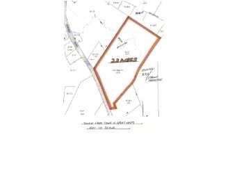
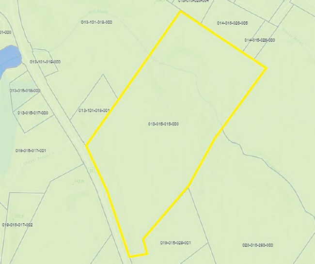
Property Record
224 Shaker Rd, Gray, ME 04039

This Property Is For Sale
Property Detail
224 Shaker Rd
GRAY-000013-000015-000015
CUMBERLAND
Vacantlandnec
Maine
RA
15-0
AE The base floodplain where base flood elevations are provided. AE Zones are now used on new format FIRMs instead of A1-A30 Zones.
22 AC
2025
NE Cumberland County
2025
Portland/South Portland
004702
Portland-South Portland, ME
NEARBY LISTINGS FOR SALE OR LEASE
-
-
View all Gray listings for sale on LoopNet.com
DEMOGRAPHICS near 224 Shaker Rd
1 mile
3 mile
5 mile
2025 Total Population
788
5,287
12,509
2030 Population
802
5,364
12,740
Pop Growth 2025-2030
+ 1.78%
+ 1.46%
+ 1.85%
Average Age
44
43
44
2025 Total Households
329
2,185
5,100
HH Growth 2025-2030
+ 1.82%
+ 1.65%
+ 2.08%
Median Household Inc
$122,999
$108,755
$106,542
Avg Household Size
2.40
2.40
2.40
2025 Avg HH Vehicles
2.00
2.00
2.00
Median Home Value
$351,980
$365,996
$374,932
Median Year Built
1986
1980
1981
Nearby Places
Map Layers
Map Styles
 Street
 Aerial
Transit
 Traffic
 Biking
Places
Listings with unknown addresses are not visible on the map
- Restaurants
- Banks
- Shops
- Fitness
- Groceries
PUBLIC TRANSPORTATION
AIRPORT
Portland International Jetport
Drive
Walk
Distance
Portland International Jetport
29 min
21.2 mi
Freight Ports
Portland, ME
Drive
Walk
Distance
Portland, ME
31 min
20.9 mi
Nearby Properties
Address
Land Use
TOTAL SIZE
Lot Size
Zoning
Address
Land Use
TOTAL SIZE
Lot Size
Zoning
6.80 AC
BUSINE
Address
Land Use
TOTAL SIZE
Lot Size
Zoning
19.06 AC
BUSINE
Address
Land Use
TOTAL SIZE
Lot Size
Zoning
66.66 AC
RA
Address
Land Use
TOTAL SIZE
Lot Size
Zoning
14,315 SF
2.25 AC
VILLAG
Address
Land Use
TOTAL SIZE
Lot Size
Zoning
9,864 SF
153.52 AC
RA
Address
Land Use
TOTAL SIZE
Lot Size
Zoning
Address
Land Use
TOTAL SIZE
Lot Size
Zoning
5.50 AC
BUSINE
Address
Land Use
TOTAL SIZE
Lot Size
Zoning
12.62 AC
VILLAG
Address
Land Use
TOTAL SIZE
Lot Size
Zoning
7,032 SF
5 AC
RB
Address
Land Use
TOTAL SIZE
Lot Size
Zoning
12.04 AC
RURAL
Address
Land Use
TOTAL SIZE
Lot Size
Zoning
10.30 AC
VILLAG
Address
Land Use
TOTAL SIZE
Lot Size
Zoning
2.76 AC
BUSINE
Address
Land Use
TOTAL SIZE
Lot Size
Zoning
20 AC
RA
Address
Land Use
TOTAL SIZE
Lot Size
Zoning
1.20 AC
VILLAG
Address
Land Use
TOTAL SIZE
Lot Size
Zoning
148 AC
RA
Address
Land Use
TOTAL SIZE
Lot Size
Zoning
6,600 SF
5.43 AC
BUSINE
Address
Land Use
TOTAL SIZE
Lot Size
Zoning
13,240 SF
9 AC
VILLAG
Address
Land Use
TOTAL SIZE
Lot Size
Zoning
2,579 SF
1.36 AC
VILLAG
Address
Land Use
TOTAL SIZE
Lot Size
Zoning
5.50 AC
VILLAG
Address
Land Use
TOTAL SIZE
Lot Size
Zoning
12 AC
RURAL
Address
Land Use
TOTAL SIZE
Lot Size
Zoning
5.83 AC
RURAL
Address
Land Use
TOTAL SIZE
Lot Size
Zoning
1.81 AC
RURAL
Address
Land Use
TOTAL SIZE
Lot Size
Zoning
243.83 AC
RA
Address
Land Use
TOTAL SIZE
Lot Size
Zoning
1.94 AC
VILLAG
Address
Land Use
TOTAL SIZE
Lot Size
Zoning
90.16 AC
RA
Address
Land Use
TOTAL SIZE
Lot Size
Zoning
11.50 AC
VILLAG
Address
Land Use
TOTAL SIZE
Lot Size
Zoning
26.51 AC
BB
Address
Land Use
TOTAL SIZE
Lot Size
Zoning
1.80 AC
BB
Address
Land Use
TOTAL SIZE
Lot Size
Zoning
1.57 AC
VILLAG
Address
Land Use
TOTAL SIZE
Lot Size
Zoning
4 AC
BUSINE
The World's #1 Commercial Real Estate Marketplace
Connect with us
© 2026 CoStar Group
The information above has been obtained from sources believed reliable. While we do not doubt its accuracy we have not verified it and make no guarantee, warranty or representation about it. It is your responsibility to independently confirm its accuracy and completeness. Any projections, opinions, assumptions, or estimates used are for example only and do not represent the current or future performance of the property. The value of this transaction to you depends on tax and other factors which should be evaluated by your tax, financial, and legal advisors. You and your advisors should conduct a careful, independent investigation of the property to determine to your satisfaction the suitability of the property for your needs.