Property Record
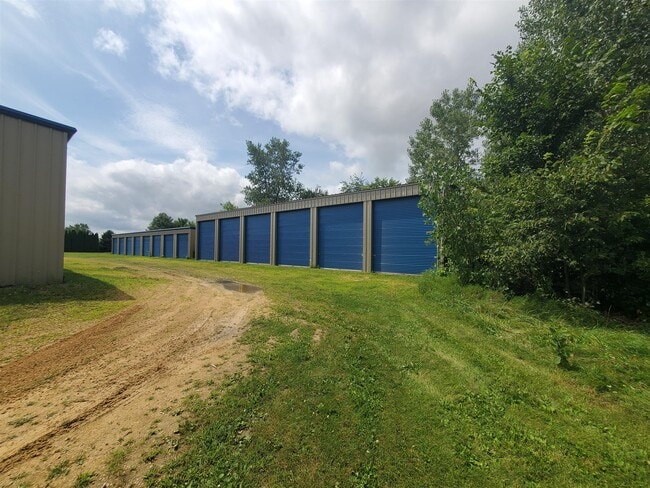
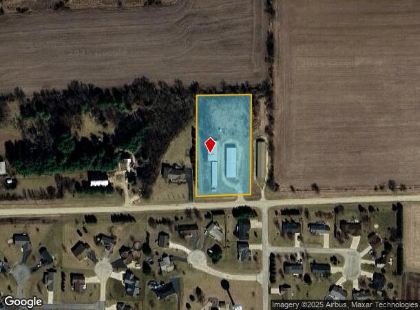
224 Sunset Dr, Orangeville, IL 61060
This Property Is For Sale
NEARBY LISTINGS FOR SALE OR LEASE
-
-
View all Orangeville listings for sale on LoopNet.com
Property Detail
224 Sunset Dr
16-03-36-201-025
PT NE1/4 SEC 36-29-7
Commercialnec
Stephenson
X
Illinois
17177C0200D
2.20 AC
2024
Illinois North Area
2024
Other Market Areas
000200
Freeport, IL
5,000 SF
DEMOGRAPHICS near 224 Sunset Dr
1 Mile
3 Mile
5 Mile
2024 Total Population
821
1,149
1,953
2029 Population
793
1,107
1,878
Pop Growth 2024-2029
(3.41%)
(3.66%)
(3.84%)
Average Age
42
43
44
2024 Total Households
357
499
839
HH Growth 2024-2029
(3.64%)
(3.61%)
(3.81%)
Median Household Inc
$68,884
$69,493
$72,130
Avg Household Size
2.30
2.30
2.30
2024 Avg HH Vehicles
2.00
2.00
2.00
Median Home Value
$148,175
$162,698
$182,652
Median Year Built
1960
1960
1959
Nearby Places
Map Layers
Map Styles
 Street
 Aerial
- Restaurants
- Banks
- Shops
- Fitness
- Groceries
Nearby Properties
Address
Land Use
TOTAL SIZE
Lot Size
Zoning
Address
Land Use
TOTAL SIZE
Lot Size
Zoning
Address
Land Use
TOTAL SIZE
Lot Size
Zoning
11,965 SF
51.09 AC
Address
Land Use
TOTAL SIZE
Lot Size
Zoning
3,233 SF
15 AC
Address
Land Use
TOTAL SIZE
Lot Size
Zoning
63.90 AC
Address
Land Use
TOTAL SIZE
Lot Size
Zoning
3,624 SF
80 AC
Address
Land Use
TOTAL SIZE
Lot Size
Zoning
2,943 SF
159.50 AC
Address
Land Use
TOTAL SIZE
Lot Size
Zoning
Address
Land Use
TOTAL SIZE
Lot Size
Zoning
16.67 AC
Address
Land Use
TOTAL SIZE
Lot Size
Zoning
86.20 AC
Address
Land Use
TOTAL SIZE
Lot Size
Zoning
Address
Land Use
TOTAL SIZE
Lot Size
Zoning
Address
Land Use
TOTAL SIZE
Lot Size
Zoning
3,096 SF
160 AC
Address
Land Use
TOTAL SIZE
Lot Size
Zoning
3,680 SF
80 AC
Address
Land Use
TOTAL SIZE
Lot Size
Zoning
Address
Land Use
TOTAL SIZE
Lot Size
Zoning
58.13 AC
Address
Land Use
TOTAL SIZE
Lot Size
Zoning
23.95 AC
Address
Land Use
TOTAL SIZE
Lot Size
Zoning
2,960 SF
114.13 AC
Address
Land Use
TOTAL SIZE
Lot Size
Zoning
114.87 AC
Address
Land Use
TOTAL SIZE
Lot Size
Zoning
114.39 AC
Address
Land Use
TOTAL SIZE
Lot Size
Zoning
93.50 AC
Address
Land Use
TOTAL SIZE
Lot Size
Zoning
20.44 AC
Address
Land Use
TOTAL SIZE
Lot Size
Zoning
4.93 AC
Address
Land Use
TOTAL SIZE
Lot Size
Zoning
2,824 SF
138.25 AC
Address
Land Use
TOTAL SIZE
Lot Size
Zoning
4,312 SF
127.56 AC
Address
Land Use
TOTAL SIZE
Lot Size
Zoning
4,113 SF
73.56 AC
Address
Land Use
TOTAL SIZE
Lot Size
Zoning
Address
Land Use
TOTAL SIZE
Lot Size
Zoning
3,897 SF
160 AC
Address
Land Use
TOTAL SIZE
Lot Size
Zoning
2,376 SF
160 AC
Address
Land Use
TOTAL SIZE
Lot Size
Zoning
4,700 SF
1.43 AC
Address
Land Use
TOTAL SIZE
Lot Size
Zoning
3,104 SF
143 AC
The World's #1 Commercial Real Estate Marketplace
Connect with us
© 2025 CoStar Group
The information above has been obtained from sources believed reliable. While we do not doubt its accuracy we have not verified it and make no guarantee, warranty or representation about it. It is your responsibility to independently confirm its accuracy and completeness. Any projections, opinions, assumptions, or estimates used are for example only and do not represent the current or future performance of the property. The value of this transaction to you depends on tax and other factors which should be evaluated by your tax, financial, and legal advisors. You and your advisors should conduct a careful, independent investigation of the property to determine to your satisfaction the suitability of the property for your needs.