Property Record
224 W Division St, Pilot Point, TX 76258
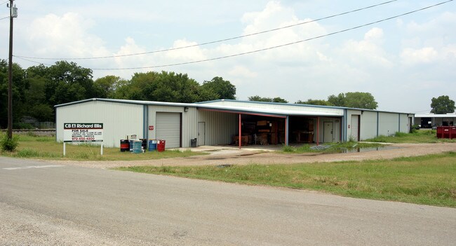

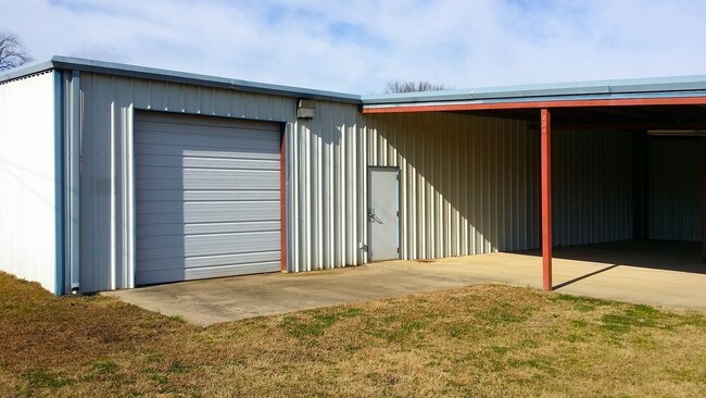

Property Detail
224 W Division St
Dallas-Fort Worth-Arlington, TX
O T PILOT POINT BLK 24 LOT 1
R39505
Denton
Industrialgeneral
Texas
B and X Area of moderate flood hazard, usually the area between the limits of the 100-year and 500-year floods.
1
2024
0.23 AC
2025
Outlying Denton County
020118
Dallas/Ft Worth
15,600 SF
NEARBY LISTINGS FOR SALE OR LEASE
DEMOGRAPHICS near 224 W Division St
1 mile
3 mile
5 mile
2024 Total Population
4,261
7,370
8,755
2029 Population
4,824
8,473
9,989
Pop Growth 2024-2029
+ 13.21%
+ 14.97%
+ 14.09%
Average Age
41
40
41
2024 Total Households
1,517
2,566
3,099
HH Growth 2024-2029
+ 13.58%
+ 15.08%
+ 14.13%
Median Household Inc
$100,132
$104,575
$103,890
Avg Household Size
2.80
2.80
2.80
2024 Avg HH Vehicles
3.00
3.00
3.00
Median Home Value
$365,249
$414,748
$447,767
Median Year Built
1995
2001
2000
Nearby Places
Map Layers
Map Styles
 Street
 Aerial
Transit
 Traffic
 Biking
Places
Listings with unknown addresses are not visible on the map
- Restaurants
- Banks
- Shops
- Fitness
- Groceries
PUBLIC TRANSPORTATION
AIRPORT
Dallas-Fort Worth International
Drive
Walk
Distance
Dallas-Fort Worth International
61 min
41.4 mi
SALE & LEASE HISTORY
LISTING DATE
SALE/LEASE

Sep 21, 2017
For Sale
Jul 27, 2017
For Sale
Jan 09, 2017
For Sale
Feb 21, 2017
For Sale
Nearby Properties
Address
Land Use
TOTAL SIZE
Lot Size
Zoning
Address
Land Use
TOTAL SIZE
Lot Size
Zoning
83,087 SF
23.24 AC
Address
Land Use
TOTAL SIZE
Lot Size
Zoning
118,721 SF
4.68 AC
Address
Land Use
TOTAL SIZE
Lot Size
Zoning
107,421 SF
15.99 AC
Address
Land Use
TOTAL SIZE
Lot Size
Zoning
312.59 AC
Address
Land Use
TOTAL SIZE
Lot Size
Zoning
210,260 SF
17.39 AC
Address
Land Use
TOTAL SIZE
Lot Size
Zoning
5,000 SF
112.65 AC
Address
Land Use
TOTAL SIZE
Lot Size
Zoning
5,951 SF
44.58 AC
Address
Land Use
TOTAL SIZE
Lot Size
Zoning
17.59 AC
Address
Land Use
TOTAL SIZE
Lot Size
Zoning
53,500 SF
3.30 AC
Address
Land Use
TOTAL SIZE
Lot Size
Zoning
123.32 AC
Address
Land Use
TOTAL SIZE
Lot Size
Zoning
42,263 SF
4.95 AC
Address
Land Use
TOTAL SIZE
Lot Size
Zoning
138,700 SF
13.42 AC
Address
Land Use
TOTAL SIZE
Lot Size
Zoning
18,648 SF
18.63 AC
Address
Land Use
TOTAL SIZE
Lot Size
Zoning
19,558 SF
2.53 AC
Address
Land Use
TOTAL SIZE
Lot Size
Zoning
33,448 SF
15 AC
Address
Land Use
TOTAL SIZE
Lot Size
Zoning
22,328 SF
8 AC
Address
Land Use
TOTAL SIZE
Lot Size
Zoning
51,500 SF
10 AC
Address
Land Use
TOTAL SIZE
Lot Size
Zoning
18,629 SF
1.61 AC
Address
Land Use
TOTAL SIZE
Lot Size
Zoning
8,640 SF
16.40 AC
Address
Land Use
TOTAL SIZE
Lot Size
Zoning
11,254 SF
9.72 AC
Address
Land Use
TOTAL SIZE
Lot Size
Zoning
Address
Land Use
TOTAL SIZE
Lot Size
Zoning
Address
Land Use
TOTAL SIZE
Lot Size
Zoning
Address
Land Use
TOTAL SIZE
Lot Size
Zoning
1,200 SF
15 AC
Address
Land Use
TOTAL SIZE
Lot Size
Zoning
Address
Land Use
TOTAL SIZE
Lot Size
Zoning
5,387 SF
18.71 AC
Address
Land Use
TOTAL SIZE
Lot Size
Zoning
41,862 SF
3.25 AC
Address
Land Use
TOTAL SIZE
Lot Size
Zoning
10,400 SF
0.46 AC
Address
Land Use
TOTAL SIZE
Lot Size
Zoning
10,995 SF
0.79 AC
Address
Land Use
TOTAL SIZE
Lot Size
Zoning
24,460 SF
0.23 AC
The World's #1 Commercial Real Estate Marketplace
Connect with us
© 2026 CoStar Group
The information above has been obtained from sources believed reliable. While we do not doubt its accuracy we have not verified it and make no guarantee, warranty or representation about it. It is your responsibility to independently confirm its accuracy and completeness. Any projections, opinions, assumptions, or estimates used are for example only and do not represent the current or future performance of the property. The value of this transaction to you depends on tax and other factors which should be evaluated by your tax, financial, and legal advisors. You and your advisors should conduct a careful, independent investigation of the property to determine to your satisfaction the suitability of the property for your needs.