Property Record
2240 Route 51, Clairton, PA 15025

Save to a Folder
{{folder.Name}}
{{folder.ListingIds.length}} Properties
{{folder.ListingIds.length}} Property
Create a New Folder
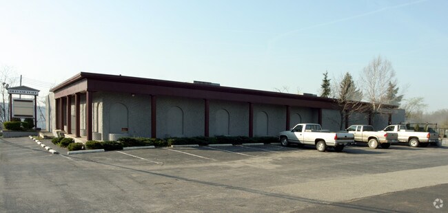
Property Detail
2240 Route 51
Pittsburgh, PA
LOT 100X200X125.76
1134-C-00155-0000-00
ALLEGHENY
Storebuilding
Pennsylvania
B and X Area of moderate flood hazard, usually the area between the limits of the 100-year and 500-year floods.
155
2026
0.52 AC
2026
South Pittsburgh/Rte 51
564500
Pittsburgh
NEARBY LISTINGS FOR SALE OR LEASE
DEMOGRAPHICS near 2240 Route 51
1 mile
3 mile
5 mile
2025 Total Population
3,015
18,633
61,519
2030 Population
3,023
18,700
61,220
Pop Growth 2025-2030
+ 0.27%
+ 0.36%
(0.49%)
Average Age
42
44
44
2025 Total Households
1,299
8,021
26,133
HH Growth 2025-2030
+ 0.46%
+ 0.47%
(0.46%)
Median Household Inc
$60,746
$64,097
$75,218
Avg Household Size
2.30
2.30
2.30
2025 Avg HH Vehicles
2.00
2.00
2.00
Median Home Value
$160,536
$163,807
$185,722
Median Year Built
1951
1953
1958
Nearby Places
Map Layers
Map Styles
 Street
 Aerial
Layers
 Traffic
 Biking
Places
Listings with unknown addresses are not visible on the map
- Restaurants
- Banks
- Shops
- Fitness
- Groceries
PUBLIC TRANSPORTATION
AIRPORT
Pittsburgh International
Drive
Walk
Distance
Pittsburgh International
56 min
30.8 mi
Arnold Palmer Regional
Drive
Walk
Distance
Arnold Palmer Regional
59 min
36.6 mi
Nearby Properties
Address
Land Use
TOTAL SIZE
Lot Size
Zoning
Address
Land Use
TOTAL SIZE
Lot Size
Zoning
160.53 AC
Address
Land Use
TOTAL SIZE
Lot Size
Zoning
51.52 AC
Address
Land Use
TOTAL SIZE
Lot Size
Zoning
2.98 AC
Address
Land Use
TOTAL SIZE
Lot Size
Zoning
72.10 AC
Address
Land Use
TOTAL SIZE
Lot Size
Zoning
35.72 AC
Address
Land Use
TOTAL SIZE
Lot Size
Zoning
Address
Land Use
TOTAL SIZE
Lot Size
Zoning
14.49 AC
Address
Land Use
TOTAL SIZE
Lot Size
Zoning
24.24 AC
Address
Land Use
TOTAL SIZE
Lot Size
Zoning
77.33 AC
Address
Land Use
TOTAL SIZE
Lot Size
Zoning
0.93 AC
Address
Land Use
TOTAL SIZE
Lot Size
Zoning
7.03 AC
Address
Land Use
TOTAL SIZE
Lot Size
Zoning
111.30 AC
Address
Land Use
TOTAL SIZE
Lot Size
Zoning
242.22 AC
Address
Land Use
TOTAL SIZE
Lot Size
Zoning
8.90 AC
Address
Land Use
TOTAL SIZE
Lot Size
Zoning
2.80 AC
Address
Land Use
TOTAL SIZE
Lot Size
Zoning
10.25 AC
Address
Land Use
TOTAL SIZE
Lot Size
Zoning
26.77 AC
Address
Land Use
TOTAL SIZE
Lot Size
Zoning
11.78 AC
Address
Land Use
TOTAL SIZE
Lot Size
Zoning
3.40 AC
Address
Land Use
TOTAL SIZE
Lot Size
Zoning
5.96 AC
Address
Land Use
TOTAL SIZE
Lot Size
Zoning
3.86 AC
Address
Land Use
TOTAL SIZE
Lot Size
Zoning
5.94 AC
Address
Land Use
TOTAL SIZE
Lot Size
Zoning
0.46 AC
Address
Land Use
TOTAL SIZE
Lot Size
Zoning
Address
Land Use
TOTAL SIZE
Lot Size
Zoning
1.56 AC
Address
Land Use
TOTAL SIZE
Lot Size
Zoning
17.68 AC
Address
Land Use
TOTAL SIZE
Lot Size
Zoning
8.55 AC
Address
Land Use
TOTAL SIZE
Lot Size
Zoning
0.46 AC
Address
Land Use
TOTAL SIZE
Lot Size
Zoning
141 AC
Address
Land Use
TOTAL SIZE
Lot Size
Zoning
5.10 AC
The World's #1 Commercial Real Estate Marketplace
Connect with us
© 2026 CoStar Group
The information above has been obtained from sources believed reliable. While we do not doubt its accuracy we have not verified it and make no guarantee, warranty or representation about it. It is your responsibility to independently confirm its accuracy and completeness. Any projections, opinions, assumptions, or estimates used are for example only and do not represent the current or future performance of the property. The value of this transaction to you depends on tax and other factors which should be evaluated by your tax, financial, and legal advisors. You and your advisors should conduct a careful, independent investigation of the property to determine to your satisfaction the suitability of the property for your needs.