No Photo
Property Record
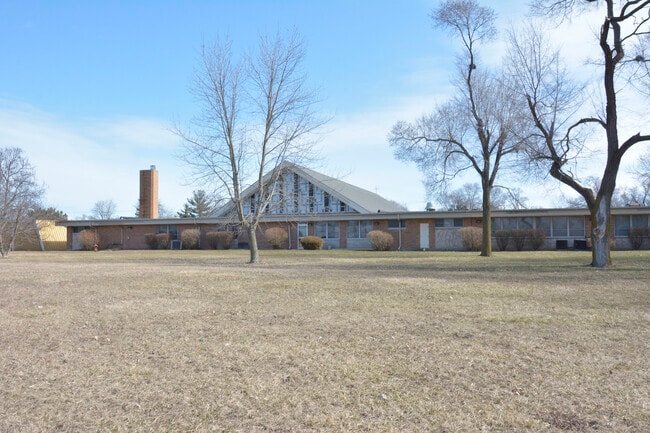
2600 223Rd St, Sauk Village, IL 60411


NEARBY LISTINGS FOR SALE OR LEASE
-
-
View all Sauk Village listings for sale on LoopNet.com
Property Detail
2600 223Rd St
32-36-201-003-0000
Cook
Taxexempt
Illinois
X
15 AC
17197C0385G
Far South
0
Chicago
2025
Chicago-Naperville-Elgin, IL-IN-WI
829700
DEMOGRAPHICS near 2600 223Rd St
1 Mile
3 Mile
5 Mile
2024 Total Population
7,951
32,568
110,764
2029 Population
7,878
32,289
109,960
Pop Growth 2024-2029
(0.92%)
(0.86%)
(0.73%)
Average Age
36
41
41
2024 Total Households
2,556
11,586
41,254
HH Growth 2024-2029
(1.17%)
(1.05%)
(0.90%)
Median Household Inc
$48,943
$69,303
$72,715
Avg Household Size
3.00
2.70
2.60
2024 Avg HH Vehicles
2.00
2.00
2.00
Median Home Value
$74,864
$199,065
$215,916
Median Year Built
1972
1980
1978
Nearby Places
Map Layers
Map Styles
 Street
 Aerial
- Restaurants
- Banks
- Shops
- Fitness
- Groceries
PUBLIC TRANSPORTATION
COMMUTER RAIL
Dyer Amtrak (Cardinal - Amtrak)
DRIVE
WALK
Distance
Dyer Amtrak (Cardinal - Amtrak)
9 min
4.2 mi
AIRPORT
Chicago Midway International
DRIVE
WALK
Distance
Chicago Midway International
45 min
29.5 mi
Freight Ports
Port Milwaukee
DRIVE
WALK
Distance
Port Milwaukee
148 min
116.0 mi
SALE & LEASE HISTORY
LISTING DATE
SALE/LEASE

Mar 17, 2024
For Sale
Nearby Properties
Address
Land Use
TOTAL SIZE
Lot Size
Zoning
Address
Land Use
TOTAL SIZE
Lot Size
Zoning
552,813 SF
26.48 AC
Address
Land Use
TOTAL SIZE
Lot Size
Zoning
81,622 SF
9.20 AC
Address
Land Use
TOTAL SIZE
Lot Size
Zoning
90,526 SF
22.99 AC
R33
Address
Land Use
TOTAL SIZE
Lot Size
Zoning
64,855 SF
5 AC
Address
Land Use
TOTAL SIZE
Lot Size
Zoning
87,836 SF
14.12 AC
R33
Address
Land Use
TOTAL SIZE
Lot Size
Zoning
62,026 SF
9.70 AC
Address
Land Use
TOTAL SIZE
Lot Size
Zoning
66,240 SF
0.45 AC
Address
Land Use
TOTAL SIZE
Lot Size
Zoning
119,758 SF
3.80 AC
Address
Land Use
TOTAL SIZE
Lot Size
Zoning
8.27 AC
Address
Land Use
TOTAL SIZE
Lot Size
Zoning
21,566 SF
25.76 AC
Address
Land Use
TOTAL SIZE
Lot Size
Zoning
77,421 SF
5.31 AC
Address
Land Use
TOTAL SIZE
Lot Size
Zoning
31,782 SF
3.05 AC
R33
Address
Land Use
TOTAL SIZE
Lot Size
Zoning
42,728 SF
3.22 AC
Address
Land Use
TOTAL SIZE
Lot Size
Zoning
4,763 SF
0.64 AC
Address
Land Use
TOTAL SIZE
Lot Size
Zoning
15,060 SF
2.38 AC
R33
Address
Land Use
TOTAL SIZE
Lot Size
Zoning
26,865 SF
2.86 AC
Address
Land Use
TOTAL SIZE
Lot Size
Zoning
4,221 SF
1.52 AC
R33
Address
Land Use
TOTAL SIZE
Lot Size
Zoning
Address
Land Use
TOTAL SIZE
Lot Size
Zoning
13,360 SF
2.03 AC
Address
Land Use
TOTAL SIZE
Lot Size
Zoning
72,404 SF
3.38 AC
Address
Land Use
TOTAL SIZE
Lot Size
Zoning
87,105 SF
7.74 AC
Address
Land Use
TOTAL SIZE
Lot Size
Zoning
18,610 SF
0.45 AC
R33
Address
Land Use
TOTAL SIZE
Lot Size
Zoning
2,845,012 SF
133.73 AC
Address
Land Use
TOTAL SIZE
Lot Size
Zoning
4,548 SF
2.04 AC
R33
Address
Land Use
TOTAL SIZE
Lot Size
Zoning
13,526 SF
1.41 AC
Address
Land Use
TOTAL SIZE
Lot Size
Zoning
304,256 SF
21.50 AC
Address
Land Use
TOTAL SIZE
Lot Size
Zoning
4,752 SF
2.33 AC
R33
Address
Land Use
TOTAL SIZE
Lot Size
Zoning
42,000 SF
3.34 AC
Address
Land Use
TOTAL SIZE
Lot Size
Zoning
22,250 SF
6.23 AC
Address
Land Use
TOTAL SIZE
Lot Size
Zoning
64,295 SF
2.23 AC
The World's #1 Commercial Real Estate Marketplace
Connect with us
© 2026 CoStar Group
The information above has been obtained from sources believed reliable. While we do not doubt its accuracy we have not verified it and make no guarantee, warranty or representation about it. It is your responsibility to independently confirm its accuracy and completeness. Any projections, opinions, assumptions, or estimates used are for example only and do not represent the current or future performance of the property. The value of this transaction to you depends on tax and other factors which should be evaluated by your tax, financial, and legal advisors. You and your advisors should conduct a careful, independent investigation of the property to determine to your satisfaction the suitability of the property for your needs.