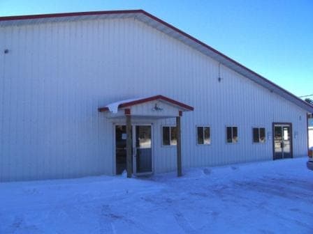
Property Record
22417 State Highway 6, Deerwood, MN 56444


Current Lease Availabilities
NEARBY LISTINGS FOR SALE OR LEASE
-
-
View all Deerwood listings for lease on LoopNet.com
Property Detail
22417 State Highway 6
Brainerd, MN
Pt Aud Sub Nenw And Gl 1,3,4. 7-46-28
59102000017C009
THAT PT OF LOTS 16 & 17 DESC AS FOL: COMM AT THE I/M AT THE NE COR OF SD GL 3 & ASSUM THE "E LINE OF
Lightindustrial
Crow Wing
X
Minnesota
27035C0456C
16,17
2025
1.60 AC
2025
Minnesota Central Area
950701
Other Market Areas
9,534 SF
DEMOGRAPHICS near 22417 State Highway 6
1 Mile
3 Mile
5 Mile
2024 Total Population
1,591
4,777
5,980
2029 Population
1,688
5,031
6,313
Pop Growth 2024-2029
+ 6.10%
+ 5.32%
+ 5.57%
Average Age
47
44
45
2024 Total Households
737
2,095
2,613
HH Growth 2024-2029
+ 5.97%
+ 5.20%
+ 5.40%
Median Household Inc
$41,154
$49,297
$53,138
Avg Household Size
2.00
2.20
2.20
2024 Avg HH Vehicles
2.00
2.00
2.00
Median Home Value
$199,999
$189,602
$199,539
Median Year Built
1975
1975
1977
Nearby Places
Map Layers
Map Styles
 Street
 Aerial
- Restaurants
- Banks
- Shops
- Fitness
- Groceries
Nearby Properties
Address
Land Use
TOTAL SIZE
Lot Size
Zoning
Address
Land Use
TOTAL SIZE
Lot Size
Zoning
200,040 SF
17.25 AC
Address
Land Use
TOTAL SIZE
Lot Size
Zoning
101,043 SF
26.64 AC
Address
Land Use
TOTAL SIZE
Lot Size
Zoning
139,176 SF
24.17 AC
Address
Land Use
TOTAL SIZE
Lot Size
Zoning
31,592 SF
4.41 AC
Address
Land Use
TOTAL SIZE
Lot Size
Zoning
45,357 SF
7.83 AC
Address
Land Use
TOTAL SIZE
Lot Size
Zoning
6,001 SF
15.20 AC
Address
Land Use
TOTAL SIZE
Lot Size
Zoning
45,719 SF
3.13 AC
Address
Land Use
TOTAL SIZE
Lot Size
Zoning
17,983 SF
0.19 AC
Address
Land Use
TOTAL SIZE
Lot Size
Zoning
9,464 SF
3.05 AC
Address
Land Use
TOTAL SIZE
Lot Size
Zoning
8,218 SF
1.54 AC
Address
Land Use
TOTAL SIZE
Lot Size
Zoning
26,270 SF
2.55 AC
Address
Land Use
TOTAL SIZE
Lot Size
Zoning
49,084 SF
5.84 AC
Address
Land Use
TOTAL SIZE
Lot Size
Zoning
20,879 SF
1.31 AC
Address
Land Use
TOTAL SIZE
Lot Size
Zoning
56,857 SF
13.28 AC
Address
Land Use
TOTAL SIZE
Lot Size
Zoning
9,884 SF
1.20 AC
Address
Land Use
TOTAL SIZE
Lot Size
Zoning
13,524 SF
19.01 AC
Address
Land Use
TOTAL SIZE
Lot Size
Zoning
11,657 SF
0.77 AC
Address
Land Use
TOTAL SIZE
Lot Size
Zoning
425.58 AC
Address
Land Use
TOTAL SIZE
Lot Size
Zoning
16,016 SF
0.72 AC
Address
Land Use
TOTAL SIZE
Lot Size
Zoning
15,988 SF
1.13 AC
Address
Land Use
TOTAL SIZE
Lot Size
Zoning
4,320 SF
1.33 AC
Address
Land Use
TOTAL SIZE
Lot Size
Zoning
8,208 SF
8.35 AC
Address
Land Use
TOTAL SIZE
Lot Size
Zoning
39,125 SF
5.53 AC
Address
Land Use
TOTAL SIZE
Lot Size
Zoning
9,776 SF
8.49 AC
Address
Land Use
TOTAL SIZE
Lot Size
Zoning
13,344 SF
0.53 AC
Address
Land Use
TOTAL SIZE
Lot Size
Zoning
8,600 SF
0.34 AC
Address
Land Use
TOTAL SIZE
Lot Size
Zoning
27,144 SF
7.60 AC
Address
Land Use
TOTAL SIZE
Lot Size
Zoning
10,394 SF
2.11 AC
The World's #1 Commercial Real Estate Marketplace
Connect with us
© 2026 CoStar Group
The information above has been obtained from sources believed reliable. While we do not doubt its accuracy we have not verified it and make no guarantee, warranty or representation about it. It is your responsibility to independently confirm its accuracy and completeness. Any projections, opinions, assumptions, or estimates used are for example only and do not represent the current or future performance of the property. The value of this transaction to you depends on tax and other factors which should be evaluated by your tax, financial, and legal advisors. You and your advisors should conduct a careful, independent investigation of the property to determine to your satisfaction the suitability of the property for your needs.