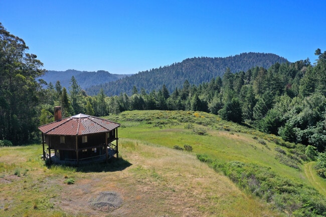
Property Record
22447 Highway 116, Monte Rio, CA 95462

Save to a Folder
{{folder.Name}}
{{folder.ListingIds.length}} Properties
{{folder.ListingIds.length}} Property
Create a New Folder
Property Detail
22447 Highway 116
072-021-005
74 FORM PT OF 097-100-01 OR 2744-363
Timberlandforesttreesagricultural
SONOMA
RRD160
California
B and X Area of moderate flood hazard, usually the area between the limits of the 100-year and 500-year floods.
42.60 AC
2025
Sebastopol/Bodega/West
2025
North Bay/Santa Rosa
153707
Santa Rosa-Petaluma, CA
NEARBY LISTINGS FOR SALE OR LEASE
DEMOGRAPHICS near 22447 Highway 116
1 mile
3 mile
5 mile
2025 Total Population
419
4,820
8,574
2030 Population
412
4,877
8,705
Pop Growth 2025-2030
(1.67%)
+ 1.18%
+ 1.53%
Average Age
52
51
50
2025 Total Households
212
2,344
4,054
HH Growth 2025-2030
(1.89%)
+ 1.32%
+ 1.65%
Median Household Inc
$85,795
$82,251
$85,618
Avg Household Size
1.90
2.00
2.00
2025 Avg HH Vehicles
2.00
2.00
2.00
Median Home Value
$706,989
$705,357
$691,947
Median Year Built
1955
1958
1958
Nearby Places
Map Layers
Map Styles
 Street
 Aerial
Layers
 Traffic
 Biking
Places
Listings with unknown addresses are not visible on the map
- Restaurants
- Banks
- Shops
- Fitness
- Groceries
PUBLIC TRANSPORTATION
AIRPORT
Charles M Schulz - Sonoma County
Drive
Walk
Distance
Charles M Schulz - Sonoma County
47 min
18.9 mi
Freight Ports
Port of Richmond
Drive
Walk
Distance
Port of Richmond
102 min
66.0 mi
SALE & LEASE HISTORY
LISTING DATE
SALE/LEASE

Aug 29, 2020
For Sale
Nearby Properties
Address
Land Use
TOTAL SIZE
Lot Size
Zoning
Address
Land Use
TOTAL SIZE
Lot Size
Zoning
4,445 SF
598.66 AC
RRD160
Address
Land Use
TOTAL SIZE
Lot Size
Zoning
26,885 SF
14.76 AC
Address
Land Use
TOTAL SIZE
Lot Size
Zoning
36,590 SF
2.38 AC
Address
Land Use
TOTAL SIZE
Lot Size
Zoning
42,530 SF
1.64 AC
C2LC
Address
Land Use
TOTAL SIZE
Lot Size
Zoning
6,726 SF
5.56 AC
Address
Land Use
TOTAL SIZE
Lot Size
Zoning
2,190 SF
1.88 AC
Address
Land Use
TOTAL SIZE
Lot Size
Zoning
3,884 SF
284.54 AC
RRD120
Address
Land Use
TOTAL SIZE
Lot Size
Zoning
3,623 SF
9.90 AC
Address
Land Use
TOTAL SIZE
Lot Size
Zoning
1,440 SF
7.06 AC
Address
Land Use
TOTAL SIZE
Lot Size
Zoning
5,040 SF
10.56 AC
Address
Land Use
TOTAL SIZE
Lot Size
Zoning
2,941 SF
3.16 AC
K
Address
Land Use
TOTAL SIZE
Lot Size
Zoning
2,017 SF
3 AC
R14UA
Address
Land Use
TOTAL SIZE
Lot Size
Zoning
2,324 SF
200 AC
RRD160
Address
Land Use
TOTAL SIZE
Lot Size
Zoning
4,276 SF
2.90 AC
AOR
Address
Land Use
TOTAL SIZE
Lot Size
Zoning
1,558 SF
5.84 AC
K
Address
Land Use
TOTAL SIZE
Lot Size
Zoning
2,288 SF
0.30 AC
Address
Land Use
TOTAL SIZE
Lot Size
Zoning
2,770 SF
16.31 AC
RRD160
Address
Land Use
TOTAL SIZE
Lot Size
Zoning
6,417 SF
0.38 AC
Address
Land Use
TOTAL SIZE
Lot Size
Zoning
208.83 AC
RRDB
Address
Land Use
TOTAL SIZE
Lot Size
Zoning
1,809 SF
260 AC
RRD160
Address
Land Use
TOTAL SIZE
Lot Size
Zoning
3,367 SF
1.28 AC
R14UA
Address
Land Use
TOTAL SIZE
Lot Size
Zoning
2,900 SF
1.09 AC
Address
Land Use
TOTAL SIZE
Lot Size
Zoning
6,688 SF
2.43 AC
KF2
Address
Land Use
TOTAL SIZE
Lot Size
Zoning
4,548 SF
4.30 AC
Address
Land Use
TOTAL SIZE
Lot Size
Zoning
2,592 SF
1.82 AC
Address
Land Use
TOTAL SIZE
Lot Size
Zoning
349.40 AC
RRD160
Address
Land Use
TOTAL SIZE
Lot Size
Zoning
3,696 SF
0.45 AC
C2LC
Address
Land Use
TOTAL SIZE
Lot Size
Zoning
4,056 SF
0.46 AC
RRB6
Address
Land Use
TOTAL SIZE
Lot Size
Zoning
5,715 SF
1.17 AC
Address
Land Use
TOTAL SIZE
Lot Size
Zoning
10,155 SF
0.51 AC
R2
The World's #1 Commercial Real Estate Marketplace
Connect with us
© 2026 CoStar Group
The information above has been obtained from sources believed reliable. While we do not doubt its accuracy we have not verified it and make no guarantee, warranty or representation about it. It is your responsibility to independently confirm its accuracy and completeness. Any projections, opinions, assumptions, or estimates used are for example only and do not represent the current or future performance of the property. The value of this transaction to you depends on tax and other factors which should be evaluated by your tax, financial, and legal advisors. You and your advisors should conduct a careful, independent investigation of the property to determine to your satisfaction the suitability of the property for your needs.