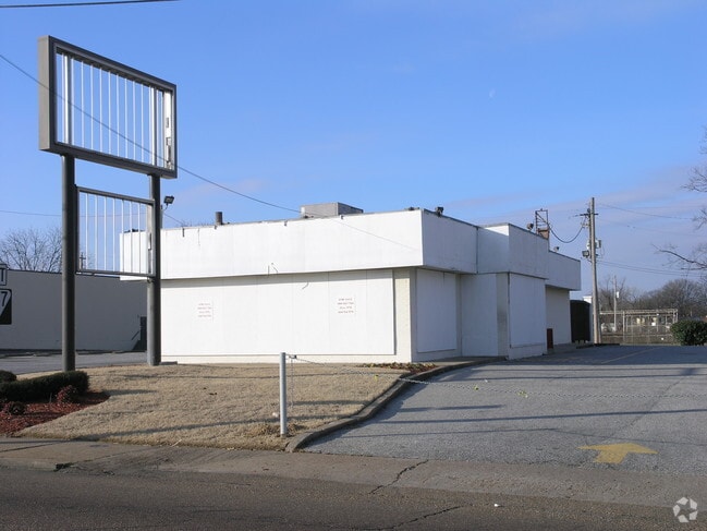
Property Record
2245 Lamar Ave, Memphis, TN 38114


NEARBY LISTINGS FOR SALE OR LEASE
Property Detail
2245 Lamar Ave
04-7020-0-0004C
Dunlap R E Unrec
Storebuilding
SW S LAMAR 287.69 NW OF KERR AVE
X
Shelby
47157C0430F
Tennessee
2024
0.93 AC
2025
Downtown/Midtown
006500
Memphis
9,020 SF
Memphis, TN-MS-AR
DEMOGRAPHICS near 2245 Lamar Ave
1 Mile
3 Mile
5 Mile
2024 Total Population
12,663
100,455
243,431
2029 Population
12,708
101,076
245,118
Pop Growth 2024-2029
+ 0.36%
+ 0.62%
+ 0.69%
Average Age
40
39
38
2024 Total Households
5,471
44,997
105,291
HH Growth 2024-2029
+ 0.15%
+ 0.44%
+ 0.56%
Median Household Inc
$39,315
$39,422
$39,491
Avg Household Size
2.30
2.10
2.20
2024 Avg HH Vehicles
1.00
1.00
1.00
Median Home Value
$124,069
$138,929
$148,593
Median Year Built
1952
1954
1957
Nearby Places
Map Layers
Map Styles
 Street
 Aerial
- Restaurants
- Banks
- Shops
- Fitness
- Groceries
PUBLIC TRANSPORTATION
COMMUTER RAIL
Central Station (Riverfront Loop - Memphis Area Transit Authority Trolley (MataTrolley))
DRIVE
WALK
Distance
Central Station (Riverfront Loop - Memphis Area Transit Authority Trolley (MataTrolley))
9 min
5.2 mi
AIRPORT
Memphis International
DRIVE
WALK
Distance
Memphis International
8 min
5.0 mi
Nearby Properties
Address
Land Use
TOTAL SIZE
Lot Size
Zoning
Address
Land Use
TOTAL SIZE
Lot Size
Zoning
115,053 SF
4.63 AC
CMU-1
Address
Land Use
TOTAL SIZE
Lot Size
Zoning
2,137 SF
346 AC
R-15
Address
Land Use
TOTAL SIZE
Lot Size
Zoning
82,064 SF
3.53 AC
CMP-1
Address
Land Use
TOTAL SIZE
Lot Size
Zoning
99,732 SF
1.08 AC
CMU-3
Address
Land Use
TOTAL SIZE
Lot Size
Zoning
100,246 SF
0.93 AC
CMU-3
Address
Land Use
TOTAL SIZE
Lot Size
Zoning
33,391 SF
1.26 AC
CMU-1
Address
Land Use
TOTAL SIZE
Lot Size
Zoning
87,504 SF
0.88 AC
CMU-3
Address
Land Use
TOTAL SIZE
Lot Size
Zoning
222,671 SF
8.77 AC
EMP
Address
Land Use
TOTAL SIZE
Lot Size
Zoning
53,088 SF
1.51 AC
CMU-3
Address
Land Use
TOTAL SIZE
Lot Size
Zoning
38,348 SF
1.74 AC
RW
Address
Land Use
TOTAL SIZE
Lot Size
Zoning
120.15 AC
RU-1
Address
Land Use
TOTAL SIZE
Lot Size
Zoning
118,073 SF
4.75 AC
CMU-1
Address
Land Use
TOTAL SIZE
Lot Size
Zoning
66,580 SF
3.75 AC
RU-3
Address
Land Use
TOTAL SIZE
Lot Size
Zoning
1,760,826 SF
109.47 AC
EMP
Address
Land Use
TOTAL SIZE
Lot Size
Zoning
26.98 AC
CMU-3
Address
Land Use
TOTAL SIZE
Lot Size
Zoning
40,270 SF
2 AC
Address
Land Use
TOTAL SIZE
Lot Size
Zoning
66,728 SF
346 AC
RS-15
Address
Land Use
TOTAL SIZE
Lot Size
Zoning
87,283 SF
2.14 AC
CMU-1
Address
Land Use
TOTAL SIZE
Lot Size
Zoning
69,204 SF
4.54 AC
CMU-3
Address
Land Use
TOTAL SIZE
Lot Size
Zoning
56,639 SF
3.59 AC
CMP-1
Address
Land Use
TOTAL SIZE
Lot Size
Zoning
190,456 SF
13.71 AC
CMU-1
Address
Land Use
TOTAL SIZE
Lot Size
Zoning
1,117,337 SF
127.15 AC
EMP
Address
Land Use
TOTAL SIZE
Lot Size
Zoning
55,250 SF
7.15 AC
CMU-3
Address
Land Use
TOTAL SIZE
Lot Size
Zoning
225,141 SF
3.06 AC
CMU-3
Address
Land Use
TOTAL SIZE
Lot Size
Zoning
45,604 SF
1.67 AC
CMP-1
Address
Land Use
TOTAL SIZE
Lot Size
Zoning
300,011 SF
17.53 AC
EMP
Address
Land Use
TOTAL SIZE
Lot Size
Zoning
81,516 SF
2.76 AC
RU-3
Address
Land Use
TOTAL SIZE
Lot Size
Zoning
90,972 SF
3.97 AC
CMP-1
Address
Land Use
TOTAL SIZE
Lot Size
Zoning
196,020 SF
3.28 AC
CMP-1
Address
Land Use
TOTAL SIZE
Lot Size
Zoning
106,268 SF
3.95 AC
CMU-3
The World's #1 Commercial Real Estate Marketplace
Connect with us
© 2025 CoStar Group
The information above has been obtained from sources believed reliable. While we do not doubt its accuracy we have not verified it and make no guarantee, warranty or representation about it. It is your responsibility to independently confirm its accuracy and completeness. Any projections, opinions, assumptions, or estimates used are for example only and do not represent the current or future performance of the property. The value of this transaction to you depends on tax and other factors which should be evaluated by your tax, financial, and legal advisors. You and your advisors should conduct a careful, independent investigation of the property to determine to your satisfaction the suitability of the property for your needs.