Property Record
2248 N Walgreens St, Flagstaff, AZ 86004


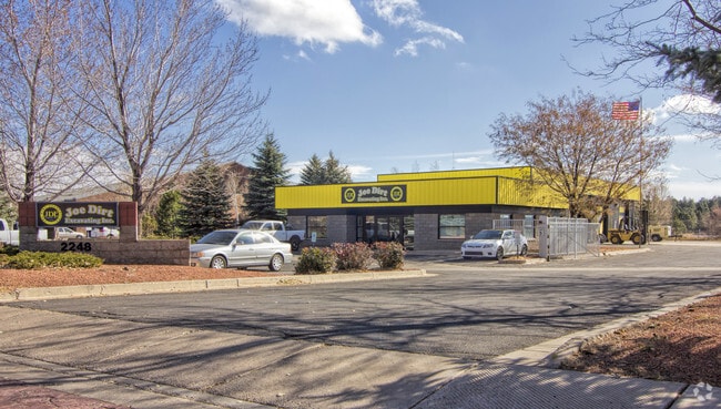
Property Detail
2248 N Walgreens St
Flagstaff, AZ
SUBDIVISION: NORTHWOODS BUSINESS CENTRE LOT: 19 & POR LOT 18 DESC AS FLLWS:BEG MOST WLY COR SD LOT 18;TH N 47D42M15S E 147.55 SD PT BEING TRUE POB;TH CONT N 47D42M15S E 147.55;TH S 42D19M00S E 299.96;TH S 47D41M43S W 147.52;TH N 42D19M20S W 299.98 TO
107-30-018C
COCONINO
Warehouse
Arizona
B and X Area of moderate flood hazard, usually the area between the limits of the 100-year and 500-year floods.
19
2024
3.05 AC
2025
Flagstaff
000800
Other Market Areas
5,942 SF
NEARBY LISTINGS FOR SALE OR LEASE
DEMOGRAPHICS near 2248 N Walgreens St
1 mile
3 mile
5 mile
2024 Total Population
9,928
35,041
70,839
2029 Population
9,610
34,206
69,954
Pop Growth 2024-2029
(3.20%)
(2.38%)
(1.25%)
Average Age
36
36
33
2024 Total Households
3,546
13,109
23,442
HH Growth 2024-2029
(4.23%)
(3.28%)
(2.40%)
Median Household Inc
$76,562
$71,515
$66,890
Avg Household Size
2.60
2.50
2.40
2024 Avg HH Vehicles
2.00
2.00
2.00
Median Home Value
$475,600
$549,903
$582,178
Median Year Built
1984
1986
1990
Nearby Places
Map Layers
Map Styles
 Street
 Aerial
Transit
 Traffic
 Biking
Places
Listings with unknown addresses are not visible on the map
- Restaurants
- Banks
- Shops
- Fitness
- Groceries
PUBLIC TRANSPORTATION
COMMUTER RAIL
Flagstaff (Southwest Chief - Amtrak)
Drive
Walk
Distance
Flagstaff (Southwest Chief - Amtrak)
7 min
3.2 mi
AIRPORT
Flagstaff Pulliam
Drive
Walk
Distance
Flagstaff Pulliam
16 min
8.4 mi
Freight Ports
Port of San Diego
Drive
Walk
Distance
Port of San Diego
539 min
490.9 mi
Nearby Properties
Address
Land Use
TOTAL SIZE
Lot Size
Zoning
Address
Land Use
TOTAL SIZE
Lot Size
Zoning
385,095 SF
13.33 AC
Address
Land Use
TOTAL SIZE
Lot Size
Zoning
475,521 SF
12.26 AC
Address
Land Use
TOTAL SIZE
Lot Size
Zoning
323,846 SF
26.50 AC
Address
Land Use
TOTAL SIZE
Lot Size
Zoning
274,862 SF
14.41 AC
Address
Land Use
TOTAL SIZE
Lot Size
Zoning
308,364 SF
2.43 AC
Address
Land Use
TOTAL SIZE
Lot Size
Zoning
599,912 SF
46.60 AC
Address
Land Use
TOTAL SIZE
Lot Size
Zoning
218,329 SF
39.12 AC
Address
Land Use
TOTAL SIZE
Lot Size
Zoning
202,220 SF
4.31 AC
Address
Land Use
TOTAL SIZE
Lot Size
Zoning
144,737 SF
15.01 AC
Address
Land Use
TOTAL SIZE
Lot Size
Zoning
125,784 SF
298.81 AC
Address
Land Use
TOTAL SIZE
Lot Size
Zoning
185,249 SF
14.29 AC
Address
Land Use
TOTAL SIZE
Lot Size
Zoning
225,645 SF
35.94 AC
Address
Land Use
TOTAL SIZE
Lot Size
Zoning
161,548 SF
6.71 AC
Address
Land Use
TOTAL SIZE
Lot Size
Zoning
170,502 SF
11.88 AC
Address
Land Use
TOTAL SIZE
Lot Size
Zoning
19.92 AC
Address
Land Use
TOTAL SIZE
Lot Size
Zoning
41,141 SF
0.92 AC
Address
Land Use
TOTAL SIZE
Lot Size
Zoning
75,751 SF
4.76 AC
Address
Land Use
TOTAL SIZE
Lot Size
Zoning
91,531 SF
6.75 AC
Address
Land Use
TOTAL SIZE
Lot Size
Zoning
228,876 SF
22.15 AC
Address
Land Use
TOTAL SIZE
Lot Size
Zoning
160,490 SF
12.40 AC
Address
Land Use
TOTAL SIZE
Lot Size
Zoning
109,623 SF
15.24 AC
Address
Land Use
TOTAL SIZE
Lot Size
Zoning
151,165 SF
13.90 AC
Address
Land Use
TOTAL SIZE
Lot Size
Zoning
51,619 SF
4.33 AC
Address
Land Use
TOTAL SIZE
Lot Size
Zoning
110,642 SF
12.40 AC
Address
Land Use
TOTAL SIZE
Lot Size
Zoning
50,798 SF
5 AC
Address
Land Use
TOTAL SIZE
Lot Size
Zoning
122,145 SF
12.23 AC
Address
Land Use
TOTAL SIZE
Lot Size
Zoning
223,699 SF
7.55 AC
Address
Land Use
TOTAL SIZE
Lot Size
Zoning
144,648 SF
12.77 AC
Address
Land Use
TOTAL SIZE
Lot Size
Zoning
40,653 SF
0.64 AC
Address
Land Use
TOTAL SIZE
Lot Size
Zoning
103,665 SF
6.19 AC
The World's #1 Commercial Real Estate Marketplace
Connect with us
© 2026 CoStar Group
The information above has been obtained from sources believed reliable. While we do not doubt its accuracy we have not verified it and make no guarantee, warranty or representation about it. It is your responsibility to independently confirm its accuracy and completeness. Any projections, opinions, assumptions, or estimates used are for example only and do not represent the current or future performance of the property. The value of this transaction to you depends on tax and other factors which should be evaluated by your tax, financial, and legal advisors. You and your advisors should conduct a careful, independent investigation of the property to determine to your satisfaction the suitability of the property for your needs.