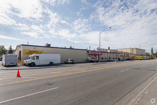
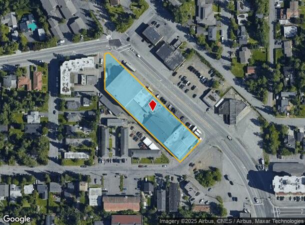
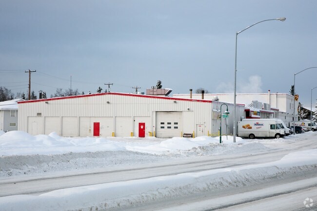
Property Record
2248 Spenard Rd, Anchorage, AK 99503
NEARBY LISTINGS FOR SALE OR LEASE
Property Detail
2248 Spenard Rd
Anchorage, AK
Romig Park
00116534000
ROMIG PARK BLK 5 LT 1A
Industrialgeneral
Anchorage
X
Alaska
0200050733D
1a
2024
1.14 AC
2025
Spenard-10
001401
Anchorage
36,464 SF
DEMOGRAPHICS near 2248 Spenard Rd
1 Mile
3 Mile
5 Mile
2024 Total Population
15,696
66,583
162,656
2029 Population
15,574
65,772
160,624
Pop Growth 2024-2029
(0.78%)
(1.22%)
(1.25%)
Average Age
41
39
37
2024 Total Households
7,487
28,472
63,826
HH Growth 2024-2029
(0.80%)
(1.24%)
(1.31%)
Median Household Inc
$73,225
$74,957
$78,199
Avg Household Size
2.00
2.20
2.40
2024 Avg HH Vehicles
2.00
2.00
2.00
Median Home Value
$413,055
$333,626
$316,125
Median Year Built
1973
1974
1978
Nearby Places
Map Layers
Map Styles
 Street
 Aerial
- Restaurants
- Banks
- Shops
- Fitness
- Groceries
PUBLIC TRANSPORTATION
AIRPORT
Merrill Field
DRIVE
WALK
Distance
Merrill Field
9 min
3.7 mi
Ted Stevens Anchorage International
DRIVE
WALK
Distance
Ted Stevens Anchorage International
9 min
4.6 mi
Freight Ports
Port of Anchorage
DRIVE
WALK
Distance
Port of Anchorage
9 min
3.4 mi
Nearby Properties
Address
Land Use
TOTAL SIZE
Lot Size
Zoning
Address
Land Use
TOTAL SIZE
Lot Size
Zoning
22,362 SF
71.05 AC
PLI
Address
Land Use
TOTAL SIZE
Lot Size
Zoning
181,492 SF
1.70 AC
B2B
Address
Land Use
TOTAL SIZE
Lot Size
Zoning
14,009 SF
24.86 AC
PLI
Address
Land Use
TOTAL SIZE
Lot Size
Zoning
199,186 SF
2.11 AC
B2B
Address
Land Use
TOTAL SIZE
Lot Size
Zoning
127,232 SF
4.55 AC
B2B
Address
Land Use
TOTAL SIZE
Lot Size
Zoning
171,692 SF
23.09 AC
I1
Address
Land Use
TOTAL SIZE
Lot Size
Zoning
117,702 SF
9.85 AC
B3SL
Address
Land Use
TOTAL SIZE
Lot Size
Zoning
134,626 SF
16.91 AC
PLI
Address
Land Use
TOTAL SIZE
Lot Size
Zoning
87,865 SF
0.48 AC
B2B
Address
Land Use
TOTAL SIZE
Lot Size
Zoning
195,079 SF
44.79 AC
PLI
Address
Land Use
TOTAL SIZE
Lot Size
Zoning
181,000 SF
7.54 AC
PLI
Address
Land Use
TOTAL SIZE
Lot Size
Zoning
86,316 SF
2 AC
B2B
Address
Land Use
TOTAL SIZE
Lot Size
Zoning
61,127 SF
3.04 AC
B3
Address
Land Use
TOTAL SIZE
Lot Size
Zoning
121,359 SF
4.35 AC
B3SL
Address
Land Use
TOTAL SIZE
Lot Size
Zoning
120,000 SF
9.09 AC
PLI
Address
Land Use
TOTAL SIZE
Lot Size
Zoning
47,774 SF
1.61 AC
B2B
Address
Land Use
TOTAL SIZE
Lot Size
Zoning
36,837 SF
0.80 AC
B2B
Address
Land Use
TOTAL SIZE
Lot Size
Zoning
124,058 SF
18.15 AC
B3
Address
Land Use
TOTAL SIZE
Lot Size
Zoning
133,758 SF
2.36 AC
ROSL
Address
Land Use
TOTAL SIZE
Lot Size
Zoning
56,747 SF
6.89 AC
B3SL
Address
Land Use
TOTAL SIZE
Lot Size
Zoning
33,360 SF
0.96 AC
B2B
Address
Land Use
TOTAL SIZE
Lot Size
Zoning
66,354 SF
44.23 AC
I2
Address
Land Use
TOTAL SIZE
Lot Size
Zoning
7,711 SF
1.93 AC
B2A
Address
Land Use
TOTAL SIZE
Lot Size
Zoning
242,189 SF
21.83 AC
I2
Address
Land Use
TOTAL SIZE
Lot Size
Zoning
168,640 SF
3.38 AC
I2
Address
Land Use
TOTAL SIZE
Lot Size
Zoning
84,157 SF
3.41 AC
B3
Address
Land Use
TOTAL SIZE
Lot Size
Zoning
170,000 SF
2.40 AC
B2A
Address
Land Use
TOTAL SIZE
Lot Size
Zoning
341,267 SF
5.51 AC
TR
Address
Land Use
TOTAL SIZE
Lot Size
Zoning
112,874 SF
6.61 AC
ROSL
Address
Land Use
TOTAL SIZE
Lot Size
Zoning
217,754 SF
14.42 AC
I1
The World's #1 Commercial Real Estate Marketplace
Connect with us
© 2026 CoStar Group
The information above has been obtained from sources believed reliable. While we do not doubt its accuracy we have not verified it and make no guarantee, warranty or representation about it. It is your responsibility to independently confirm its accuracy and completeness. Any projections, opinions, assumptions, or estimates used are for example only and do not represent the current or future performance of the property. The value of this transaction to you depends on tax and other factors which should be evaluated by your tax, financial, and legal advisors. You and your advisors should conduct a careful, independent investigation of the property to determine to your satisfaction the suitability of the property for your needs.