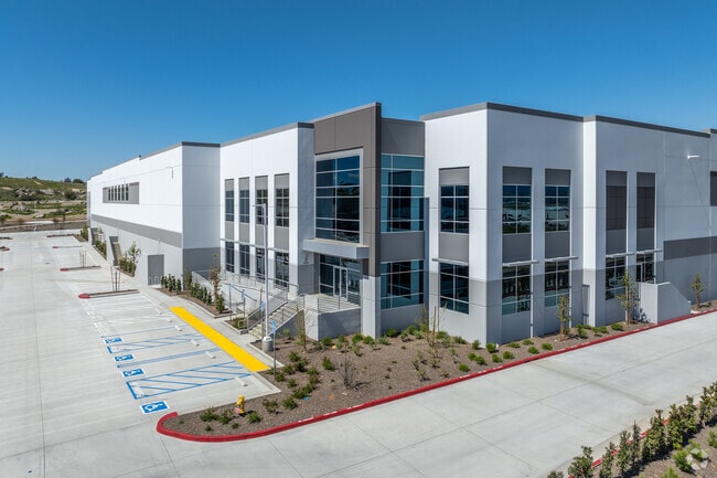
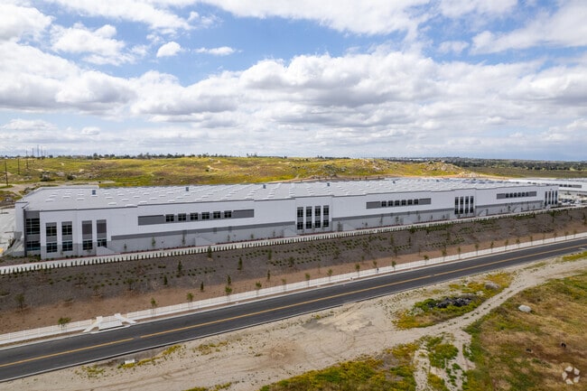
Property Record
22491 Harley Knox Blvd, Perris, CA 92570


NEARBY LISTINGS FOR SALE OR LEASE
Property Detail
22491 Harley Knox Blvd
Riverside-San Bernardino-Ontario, CA
Parcel Map No. 5128
295-310-086
ACRES 21.80000000 ACREAGEQUALCODE ML LOTTYPE P PARCEL 3-P, 4-P MAPPLATB 008 MAPPLATP 054 SUBDIVISIONNAME PM 5128
Lightindustrial
Riverside
2024
California
2025
21.80 AC
042010
Moreno Valley/Perris
348,375 SF
Inland Empire (California)
DEMOGRAPHICS near 22491 Harley Knox Blvd
1 Mile
3 Mile
5 Mile
2024 Total Population
2,806
27,729
179,827
2029 Population
2,917
29,075
188,382
Pop Growth 2024-2029
+ 3.96%
+ 4.85%
+ 4.76%
Average Age
34
36
34
2024 Total Households
631
6,906
45,344
HH Growth 2024-2029
+ 3.33%
+ 4.75%
+ 4.33%
Median Household Inc
$67,217
$91,750
$79,972
Avg Household Size
4.10
3.70
3.80
2024 Avg HH Vehicles
3.00
3.00
3.00
Median Home Value
$312,766
$482,859
$421,745
Median Year Built
1982
1987
1989
Nearby Places
Map Layers
Map Styles
 Street
 Aerial
- Restaurants
- Banks
- Shops
- Fitness
- Groceries
PUBLIC TRANSPORTATION
COMMUTER RAIL
DRIVE
WALK
Distance
8 min
4.8 mi
DRIVE
WALK
Distance
9 min
6.3 mi
AIRPORT
Ontario International
DRIVE
WALK
Distance
Ontario International
35 min
27.5 mi
John Wayne/Orange County
DRIVE
WALK
Distance
John Wayne/Orange County
65 min
49.6 mi
SALE & LEASE HISTORY
LISTING DATE
SALE/LEASE

May 20, 2022
For Lease
Nearby Properties
Address
Land Use
TOTAL SIZE
Lot Size
Zoning
Address
Land Use
TOTAL SIZE
Lot Size
Zoning
1,530,974 SF
71.21 AC
Address
Land Use
TOTAL SIZE
Lot Size
Zoning
1,851,898 SF
128.07 AC
Address
Land Use
TOTAL SIZE
Lot Size
Zoning
1,189,664 SF
55.26 AC
Address
Land Use
TOTAL SIZE
Lot Size
Zoning
1,101,504 SF
59.45 AC
Address
Land Use
TOTAL SIZE
Lot Size
Zoning
1,009,869 SF
46.76 AC
Address
Land Use
TOTAL SIZE
Lot Size
Zoning
783,407 SF
36.72 AC
Address
Land Use
TOTAL SIZE
Lot Size
Zoning
782,209 SF
35.98 AC
Address
Land Use
TOTAL SIZE
Lot Size
Zoning
656,695 SF
30.75 AC
RA5
Address
Land Use
TOTAL SIZE
Lot Size
Zoning
1,138,800 SF
43.93 AC
Address
Land Use
TOTAL SIZE
Lot Size
Zoning
1,309,754 SF
57.79 AC
IL
Address
Land Use
TOTAL SIZE
Lot Size
Zoning
1,331,763 SF
62.60 AC
Address
Land Use
TOTAL SIZE
Lot Size
Zoning
579,708 SF
17.70 AC
LI
Address
Land Use
TOTAL SIZE
Lot Size
Zoning
678,087 SF
30.24 AC
Address
Land Use
TOTAL SIZE
Lot Size
Zoning
83.15 AC
Address
Land Use
TOTAL SIZE
Lot Size
Zoning
1,461,146 SF
72.62 AC
Address
Land Use
TOTAL SIZE
Lot Size
Zoning
436,350 SF
19.47 AC
Address
Land Use
TOTAL SIZE
Lot Size
Zoning
1,364,580 SF
80.02 AC
Address
Land Use
TOTAL SIZE
Lot Size
Zoning
692,465 SF
34.46 AC
Address
Land Use
TOTAL SIZE
Lot Size
Zoning
695,786 SF
92.37 AC
Address
Land Use
TOTAL SIZE
Lot Size
Zoning
1,007,387 SF
48.02 AC
RR
Address
Land Use
TOTAL SIZE
Lot Size
Zoning
340,285 SF
14.39 AC
Address
Land Use
TOTAL SIZE
Lot Size
Zoning
1,297,200 SF
57.36 AC
Address
Land Use
TOTAL SIZE
Lot Size
Zoning
1,172,289 SF
41.82 AC
Address
Land Use
TOTAL SIZE
Lot Size
Zoning
332,377 SF
21.12 AC
Address
Land Use
TOTAL SIZE
Lot Size
Zoning
1,582,985 SF
83.28 AC
LI
Address
Land Use
TOTAL SIZE
Lot Size
Zoning
285,482 SF
9.65 AC
Address
Land Use
TOTAL SIZE
Lot Size
Zoning
481,636 SF
45 AC
The World's #1 Commercial Real Estate Marketplace
Connect with us
© 2025 CoStar Group
The information above has been obtained from sources believed reliable. While we do not doubt its accuracy we have not verified it and make no guarantee, warranty or representation about it. It is your responsibility to independently confirm its accuracy and completeness. Any projections, opinions, assumptions, or estimates used are for example only and do not represent the current or future performance of the property. The value of this transaction to you depends on tax and other factors which should be evaluated by your tax, financial, and legal advisors. You and your advisors should conduct a careful, independent investigation of the property to determine to your satisfaction the suitability of the property for your needs.