Property Record
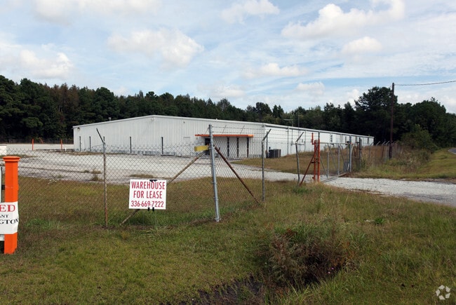
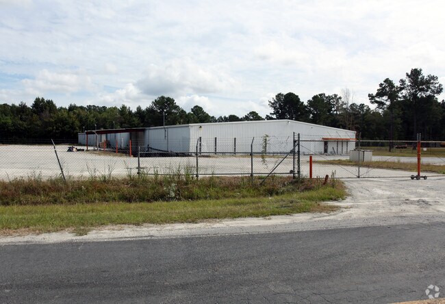
225 Crowatan Rd, Castle Hayne, NC 28429

Property Detail
225 Crowatan Rd
R01720-003-001-000
LOT 9 BLUE COVE SEC 1
Warehouse
New Hanover
I-1,INDUST
North Carolina
B and X Area of moderate flood hazard, usually the area between the limits of the 100-year and 500-year floods.
9
2025
2.85 AC
2025
Castle Hayne
011504
Wilmington
25,075 SF
Wilmington, NC
NEARBY LISTINGS FOR SALE OR LEASE
DEMOGRAPHICS near 225 Crowatan Rd
1 mile
3 mile
5 mile
2025 Total Population
772
14,006
35,548
2030 Population
824
14,849
37,704
Pop Growth 2025-2030
+ 6.74%
+ 6.02%
+ 6.07%
Average Age
41
42
41
2025 Total Households
294
5,523
14,091
HH Growth 2025-2030
+ 6.80%
+ 5.94%
+ 6.03%
Median Household Inc
$74,544
$68,800
$70,902
Avg Household Size
2.30
2.40
2.40
2025 Avg HH Vehicles
2.00
2.00
2.00
Median Home Value
$323,485
$302,145
$305,969
Median Year Built
1999
1994
1994
Nearby Places
Map Layers
Map Styles
 Street
 Aerial
Transit
 Traffic
 Biking
Places
Listings with unknown addresses are not visible on the map
- Restaurants
- Banks
- Shops
- Fitness
- Groceries
PUBLIC TRANSPORTATION
AIRPORT
Wilmington International
Drive
Walk
Distance
Wilmington International
15 min
5.4 mi
Albert J Ellis
Drive
Walk
Distance
Albert J Ellis
72 min
49.5 mi
Freight Ports
Port of Wilmington
Drive
Walk
Distance
Port of Wilmington
23 min
10.6 mi
Nearby Properties
Address
Land Use
TOTAL SIZE
Lot Size
Zoning
Address
Land Use
TOTAL SIZE
Lot Size
Zoning
117,254 SF
100.98 AC
O&I,OFFICE
Address
Land Use
TOTAL SIZE
Lot Size
Zoning
8,208 SF
186.06 AC
I-2,INDUST
Address
Land Use
TOTAL SIZE
Lot Size
Zoning
122,180 SF
1,501.54 AC
I-2,INDUST
Address
Land Use
TOTAL SIZE
Lot Size
Zoning
17,676 SF
110.44 AC
I-2,INDUST
Address
Land Use
TOTAL SIZE
Lot Size
Zoning
78,771 SF
59.13 AC
R-15,RESID
Address
Land Use
TOTAL SIZE
Lot Size
Zoning
62,960 SF
49.51 AC
R-15,RESID
Address
Land Use
TOTAL SIZE
Lot Size
Zoning
211,032 SF
25.35 AC
I-2,INDUST
Address
Land Use
TOTAL SIZE
Lot Size
Zoning
21,177 SF
11.10 AC
PD,PLANNED
Address
Land Use
TOTAL SIZE
Lot Size
Zoning
214,240 SF
18.47 AC
PD,PLANNED
Address
Land Use
TOTAL SIZE
Lot Size
Zoning
84,864 SF
8.25 AC
PD,PLANNED
Address
Land Use
TOTAL SIZE
Lot Size
Zoning
79,265 SF
29.01 AC
R-15,RESID
Address
Land Use
TOTAL SIZE
Lot Size
Zoning
48,904 SF
79.31 AC
R-15,RESID
Address
Land Use
TOTAL SIZE
Lot Size
Zoning
300.01 AC
R-15,RESID
Address
Land Use
TOTAL SIZE
Lot Size
Zoning
58,628 SF
1.52 AC
O&I,OFFICE
Address
Land Use
TOTAL SIZE
Lot Size
Zoning
3,150 SF
10.39 AC
B-2,BUSINE
Address
Land Use
TOTAL SIZE
Lot Size
Zoning
64,355 SF
4.53 AC
PD,PLANNED
Address
Land Use
TOTAL SIZE
Lot Size
Zoning
30,000 SF
8.71 AC
I-2,INDUST
Address
Land Use
TOTAL SIZE
Lot Size
Zoning
82,723 SF
9.77 AC
PD,PLANNED
Address
Land Use
TOTAL SIZE
Lot Size
Zoning
66,444 SF
6.48 AC
PD,PLANNED
Address
Land Use
TOTAL SIZE
Lot Size
Zoning
3,444 SF
6.33 AC
B-2,BUSINE
Address
Land Use
TOTAL SIZE
Lot Size
Zoning
8,600 SF
4.55 AC
PD,PLANNED
Address
Land Use
TOTAL SIZE
Lot Size
Zoning
23,840 SF
9.06 AC
R-20,RESID
Address
Land Use
TOTAL SIZE
Lot Size
Zoning
254.24 AC
R-15,RESID
Address
Land Use
TOTAL SIZE
Lot Size
Zoning
45,129 SF
7.70 AC
PD,PLANNED
Address
Land Use
TOTAL SIZE
Lot Size
Zoning
159.41 AC
R-15,RESID
Address
Land Use
TOTAL SIZE
Lot Size
Zoning
47,505 SF
7.58 AC
SC,SHOPPIN
Address
Land Use
TOTAL SIZE
Lot Size
Zoning
936 SF
29.45 AC
O&I,OFFICE
Address
Land Use
TOTAL SIZE
Lot Size
Zoning
61,380 SF
5.69 AC
PD,PLANNED
Address
Land Use
TOTAL SIZE
Lot Size
Zoning
189.42 AC
R-15,RESID
Address
Land Use
TOTAL SIZE
Lot Size
Zoning
62,539 SF
6.29 AC
PD,PLANNED
The World's #1 Commercial Real Estate Marketplace
Connect with us
© 2026 CoStar Group
The information above has been obtained from sources believed reliable. While we do not doubt its accuracy we have not verified it and make no guarantee, warranty or representation about it. It is your responsibility to independently confirm its accuracy and completeness. Any projections, opinions, assumptions, or estimates used are for example only and do not represent the current or future performance of the property. The value of this transaction to you depends on tax and other factors which should be evaluated by your tax, financial, and legal advisors. You and your advisors should conduct a careful, independent investigation of the property to determine to your satisfaction the suitability of the property for your needs.