Property Record
225 E 225 E E, Whiteland, IN 46184
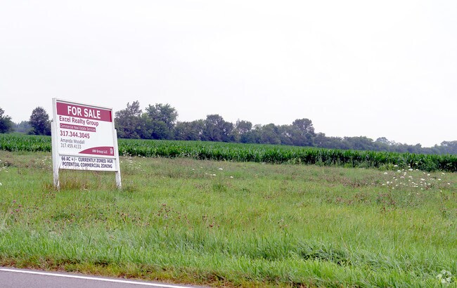
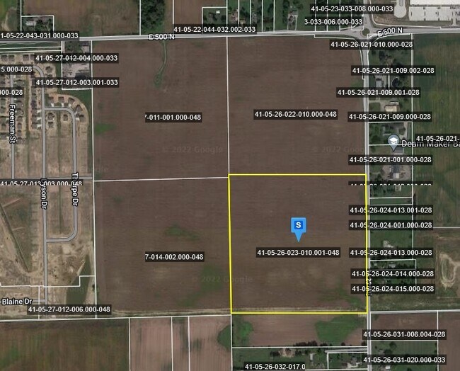
Property Detail
225 E 225 E E
Indianapolis-Carmel-Greenwood, IN
NW S26 T13 R4
41-05-26-022-010.000-048
JOHNSON
Agriculturalland
Indiana
2022
38.95 AC
2022
Far South Johnson Cty
610502
Indianapolis
NEARBY LISTINGS FOR SALE OR LEASE
DEMOGRAPHICS near 225 E 225 E E
1 mile
3 mile
5 mile
2025 Total Population
2,384
21,300
77,419
2030 Population
2,566
22,513
81,241
Pop Growth 2025-2030
+ 7.63%
+ 5.69%
+ 4.94%
Average Age
39
38
38
2025 Total Households
868
7,597
28,821
HH Growth 2025-2030
+ 7.95%
+ 5.86%
+ 5.08%
Median Household Inc
$96,640
$96,194
$92,355
Avg Household Size
2.70
2.80
2.60
2025 Avg HH Vehicles
2.00
2.00
2.00
Median Home Value
$213,694
$247,839
$266,924
Median Year Built
1997
1996
1996
Nearby Places
Map Layers
Map Styles
 Street
 Aerial
Transit
 Traffic
 Biking
Places
Listings with unknown addresses are not visible on the map
- Restaurants
- Banks
- Shops
- Fitness
- Groceries
PUBLIC TRANSPORTATION
AIRPORT
Indianapolis International
Drive
Walk
Distance
Indianapolis International
42 min
24.8 mi
Freight Ports
Port of Toledo
Drive
Walk
Distance
Port of Toledo
290 min
240.0 mi
Nearby Properties
Address
Land Use
TOTAL SIZE
Lot Size
Zoning
Address
Land Use
TOTAL SIZE
Lot Size
Zoning
1,057,350 SF
60.62 AC
Address
Land Use
TOTAL SIZE
Lot Size
Zoning
984,410 SF
55.55 AC
Address
Land Use
TOTAL SIZE
Lot Size
Zoning
845,880 SF
45.31 AC
Address
Land Use
TOTAL SIZE
Lot Size
Zoning
84.07 AC
Address
Land Use
TOTAL SIZE
Lot Size
Zoning
997,650 SF
67.25 AC
Address
Land Use
TOTAL SIZE
Lot Size
Zoning
816,376 SF
65.10 AC
Address
Land Use
TOTAL SIZE
Lot Size
Zoning
826,800 SF
62.89 AC
Address
Land Use
TOTAL SIZE
Lot Size
Zoning
34.59 AC
Address
Land Use
TOTAL SIZE
Lot Size
Zoning
588,200 SF
44.31 AC
Address
Land Use
TOTAL SIZE
Lot Size
Zoning
530,400 SF
29.63 AC
Address
Land Use
TOTAL SIZE
Lot Size
Zoning
32.60 AC
Address
Land Use
TOTAL SIZE
Lot Size
Zoning
145,921 SF
8.52 AC
Address
Land Use
TOTAL SIZE
Lot Size
Zoning
56,100 SF
50.05 AC
Address
Land Use
TOTAL SIZE
Lot Size
Zoning
342,627 SF
69.52 AC
Address
Land Use
TOTAL SIZE
Lot Size
Zoning
6,272 SF
21.91 AC
Address
Land Use
TOTAL SIZE
Lot Size
Zoning
2,008 SF
9.86 AC
Address
Land Use
TOTAL SIZE
Lot Size
Zoning
136,760 SF
31.47 AC
Address
Land Use
TOTAL SIZE
Lot Size
Zoning
178,880 SF
9.03 AC
Address
Land Use
TOTAL SIZE
Lot Size
Zoning
Address
Land Use
TOTAL SIZE
Lot Size
Zoning
58,711 SF
13.71 AC
Address
Land Use
TOTAL SIZE
Lot Size
Zoning
168,480 SF
8.42 AC
Address
Land Use
TOTAL SIZE
Lot Size
Zoning
130,440 SF
10.05 AC
Address
Land Use
TOTAL SIZE
Lot Size
Zoning
114,852 SF
8.50 AC
Address
Land Use
TOTAL SIZE
Lot Size
Zoning
3,877 SF
12.91 AC
Address
Land Use
TOTAL SIZE
Lot Size
Zoning
94,429 SF
8.21 AC
Address
Land Use
TOTAL SIZE
Lot Size
Zoning
Address
Land Use
TOTAL SIZE
Lot Size
Zoning
15,504 SF
72.69 AC
Address
Land Use
TOTAL SIZE
Lot Size
Zoning
64,299 SF
8.22 AC
Address
Land Use
TOTAL SIZE
Lot Size
Zoning
88,000 SF
26.01 AC
Address
Land Use
TOTAL SIZE
Lot Size
Zoning
88,925 SF
11.24 AC
The World's #1 Commercial Real Estate Marketplace
Connect with us
© 2026 CoStar Group
The information above has been obtained from sources believed reliable. While we do not doubt its accuracy we have not verified it and make no guarantee, warranty or representation about it. It is your responsibility to independently confirm its accuracy and completeness. Any projections, opinions, assumptions, or estimates used are for example only and do not represent the current or future performance of the property. The value of this transaction to you depends on tax and other factors which should be evaluated by your tax, financial, and legal advisors. You and your advisors should conduct a careful, independent investigation of the property to determine to your satisfaction the suitability of the property for your needs.