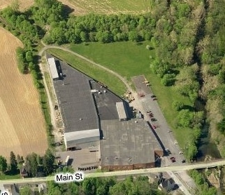
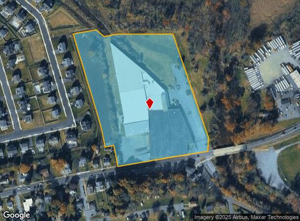
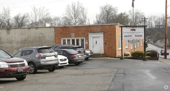
Property Record
225 Main St, Tatamy, PA 18085
NEARBY LISTINGS FOR SALE OR LEASE
Property Detail
225 Main St
Manufacturinglight
Northampton
AE
Pennsylvania
42095C0257E
10.76 AC
2025
Lehigh Valley
2025
Philadelphia
017000
Allentown-Bethlehem-Easton, PA-NJ
163,823 SF
J9SW1D-1-1-0430
DEMOGRAPHICS near 225 Main St
1 Mile
3 Mile
5 Mile
2024 Total Population
3,921
32,014
107,267
2029 Population
3,972
32,313
108,286
Pop Growth 2024-2029
+ 1.30%
+ 0.93%
+ 0.95%
Average Age
45
43
41
2024 Total Households
1,521
12,243
40,219
HH Growth 2024-2029
+ 1.38%
+ 0.99%
+ 0.96%
Median Household Inc
$99,776
$105,139
$80,312
Avg Household Size
2.50
2.60
2.50
2024 Avg HH Vehicles
2.00
2.00
2.00
Median Home Value
$298,200
$299,236
$258,374
Median Year Built
2002
1995
1962
Nearby Places
- Restaurants
- Banks
- Shops
- Fitness
- Groceries
PUBLIC TRANSPORTATION
AIRPORT
Lehigh Valley International
DRIVE
WALK
Distance
Lehigh Valley International
23 min
14.6 mi
Freight Ports
Port of Philadelphia
DRIVE
WALK
Distance
Port of Philadelphia
102 min
64.5 mi
SALE & LEASE HISTORY
LISTING DATE
SALE/LEASE

Sep 23, 2016
For Sale
Nov 10, 2017
For Lease
Nearby Properties
Address
Land Use
TOTAL SIZE
Lot Size
Zoning
Address
Land Use
TOTAL SIZE
Lot Size
Zoning
1,001,315 SF
68.62 AC
I
Address
Land Use
TOTAL SIZE
Lot Size
Zoning
1,080,846 SF
74.80 AC
I
Address
Land Use
TOTAL SIZE
Lot Size
Zoning
127,731 SF
56.29 AC
R12
Address
Land Use
TOTAL SIZE
Lot Size
Zoning
491,371 SF
32.30 AC
GI
Address
Land Use
TOTAL SIZE
Lot Size
Zoning
1,107,596 SF
62.46 AC
RA
Address
Land Use
TOTAL SIZE
Lot Size
Zoning
205,594 SF
61.99 AC
C
Address
Land Use
TOTAL SIZE
Lot Size
Zoning
1,020,930 SF
73.10 AC
RA
Address
Land Use
TOTAL SIZE
Lot Size
Zoning
344,973 SF
42.25 AC
PIC
Address
Land Use
TOTAL SIZE
Lot Size
Zoning
654,480 SF
43.28 AC
RA
Address
Land Use
TOTAL SIZE
Lot Size
Zoning
76.92 AC
RA
Address
Land Use
TOTAL SIZE
Lot Size
Zoning
358,875 SF
39.99 AC
PO/IP
Address
Land Use
TOTAL SIZE
Lot Size
Zoning
4,913 SF
27.03 AC
PIC
Address
Land Use
TOTAL SIZE
Lot Size
Zoning
472,529 SF
43.86 AC
A
Address
Land Use
TOTAL SIZE
Lot Size
Zoning
130,145 SF
21.19 AC
R3
Address
Land Use
TOTAL SIZE
Lot Size
Zoning
503,770 SF
36.05 AC
LI
Address
Land Use
TOTAL SIZE
Lot Size
Zoning
49.45 AC
RA
Address
Land Use
TOTAL SIZE
Lot Size
Zoning
407,685 SF
35.05 AC
RA
Address
Land Use
TOTAL SIZE
Lot Size
Zoning
247,226 SF
33.68 AC
DP/IP
Address
Land Use
TOTAL SIZE
Lot Size
Zoning
159,194 SF
42.07 AC
I1
Address
Land Use
TOTAL SIZE
Lot Size
Zoning
160,000 SF
38.72 AC
GI
Address
Land Use
TOTAL SIZE
Lot Size
Zoning
8,390 SF
126.60 AC
I
Address
Land Use
TOTAL SIZE
Lot Size
Zoning
437,029 SF
32 AC
GI
Address
Land Use
TOTAL SIZE
Lot Size
Zoning
242,206 SF
23.01 AC
LI
Address
Land Use
TOTAL SIZE
Lot Size
Zoning
342,820 SF
26.20 AC
RA
Address
Land Use
TOTAL SIZE
Lot Size
Zoning
93,785 SF
76.54 AC
RR
Address
Land Use
TOTAL SIZE
Lot Size
Zoning
281,400 SF
19.80 AC
PO/IP
Address
Land Use
TOTAL SIZE
Lot Size
Zoning
359,742 SF
12.64 AC
LI
Address
Land Use
TOTAL SIZE
Lot Size
Zoning
94,794 SF
17.51 AC
GB
Address
Land Use
TOTAL SIZE
Lot Size
Zoning
111,271 SF
15.32 AC
C
Address
Land Use
TOTAL SIZE
Lot Size
Zoning
254,848 SF
19.50 AC
PO/IP
The World's #1 Commercial Real Estate Marketplace
Connect with us
© 2025 CoStar Group
The information above has been obtained from sources believed reliable. While we do not doubt its accuracy we have not verified it and make no guarantee, warranty or representation about it. It is your responsibility to independently confirm its accuracy and completeness. Any projections, opinions, assumptions, or estimates used are for example only and do not represent the current or future performance of the property. The value of this transaction to you depends on tax and other factors which should be evaluated by your tax, financial, and legal advisors. You and your advisors should conduct a careful, independent investigation of the property to determine to your satisfaction the suitability of the property for your needs.