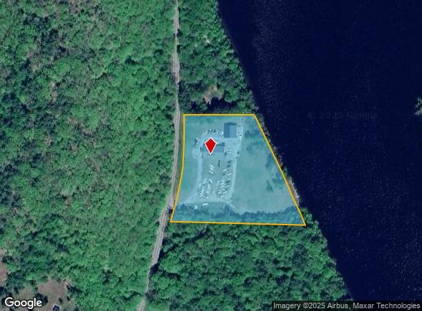
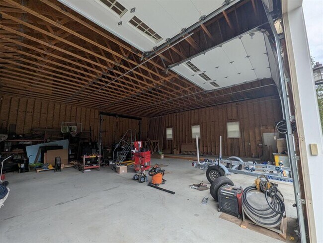
Property Record
225 Missing Link Rd, Bellows Falls, VT 05101
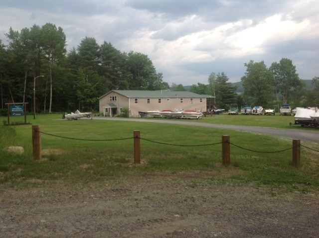
This Property Is For Sale
NEARBY LISTINGS FOR SALE OR LEASE
-
-
View all Bellows Falls listings for sale on LoopNet.com
Property Detail
225 Missing Link Rd
528-166-11774
LAND AND BUILDINGS
Commercialnec
Windham
AE
Vermont
50025C0104E
5 AC
2022
Vermont South Area
2024
Other Market Areas
967100
Brattleboro, VT
DEMOGRAPHICS near 225 Missing Link Rd
1 Mile
3 Mile
5 Mile
2024 Total Population
307
1,287
9,122
2029 Population
317
1,318
9,276
Pop Growth 2024-2029
+ 3.26%
+ 2.41%
+ 1.69%
Average Age
46
45
44
2024 Total Households
130
553
4,010
HH Growth 2024-2029
+ 3.08%
+ 2.17%
+ 1.42%
Median Household Inc
$69,230
$72,980
$62,221
Avg Household Size
2.20
2.20
2.20
2024 Avg HH Vehicles
2.00
2.00
2.00
Median Home Value
$177,940
$195,619
$176,822
Median Year Built
1976
1969
1961
Nearby Places
Map Layers
Map Styles
 Street
 Aerial
- Restaurants
- Banks
- Shops
- Fitness
- Groceries
PUBLIC TRANSPORTATION
COMMUTER RAIL
Bellows Falls Amtrak Station (Vermonter - Amtrak)
DRIVE
WALK
Distance
Bellows Falls Amtrak Station (Vermonter - Amtrak)
7 min
4.4 mi
Freight Ports
Albany, NY Port
DRIVE
WALK
Distance
Albany, NY Port
153 min
100.1 mi
Nearby Properties
Address
Land Use
TOTAL SIZE
Lot Size
Zoning
Address
Land Use
TOTAL SIZE
Lot Size
Zoning
137,353 SF
78.12 AC
Address
Land Use
TOTAL SIZE
Lot Size
Zoning
29,488 SF
11.59 AC
Address
Land Use
TOTAL SIZE
Lot Size
Zoning
31,161 SF
2.36 AC
NRB11N
Address
Land Use
TOTAL SIZE
Lot Size
Zoning
13.28 AC
Address
Land Use
TOTAL SIZE
Lot Size
Zoning
62,674 SF
5.65 AC
NRB11N
Address
Land Use
TOTAL SIZE
Lot Size
Zoning
2,076 SF
20 AC
Address
Land Use
TOTAL SIZE
Lot Size
Zoning
13.20 AC
Address
Land Use
TOTAL SIZE
Lot Size
Zoning
13.20 AC
Address
Land Use
TOTAL SIZE
Lot Size
Zoning
12.70 AC
Address
Land Use
TOTAL SIZE
Lot Size
Zoning
3.38 AC
Address
Land Use
TOTAL SIZE
Lot Size
Zoning
45,009 SF
2.45 AC
NRB11N
Address
Land Use
TOTAL SIZE
Lot Size
Zoning
Address
Land Use
TOTAL SIZE
Lot Size
Zoning
61,104 SF
10.95 AC
Address
Land Use
TOTAL SIZE
Lot Size
Zoning
59,040 SF
3.70 AC
NIND N
Address
Land Use
TOTAL SIZE
Lot Size
Zoning
19,605 SF
37.46 AC
Address
Land Use
TOTAL SIZE
Lot Size
Zoning
27,145 SF
3.11 AC
IND I
Address
Land Use
TOTAL SIZE
Lot Size
Zoning
23,308 SF
3.42 AC
NIND N
Address
Land Use
TOTAL SIZE
Lot Size
Zoning
Address
Land Use
TOTAL SIZE
Lot Size
Zoning
16,064 SF
1.39 AC
NRB11N
Address
Land Use
TOTAL SIZE
Lot Size
Zoning
5,790 SF
3.89 AC
NRB11N
Address
Land Use
TOTAL SIZE
Lot Size
Zoning
31,505 SF
2.59 AC
Address
Land Use
TOTAL SIZE
Lot Size
Zoning
31,505 SF
2.59 AC
Address
Land Use
TOTAL SIZE
Lot Size
Zoning
759 AC
Address
Land Use
TOTAL SIZE
Lot Size
Zoning
Address
Land Use
TOTAL SIZE
Lot Size
Zoning
2,558 SF
0.64 AC
NIND N
Address
Land Use
TOTAL SIZE
Lot Size
Zoning
3.60 AC
NRB11N
Address
Land Use
TOTAL SIZE
Lot Size
Zoning
4,635 SF
46.10 AC
Address
Land Use
TOTAL SIZE
Lot Size
Zoning
18,900 SF
7 AC
Address
Land Use
TOTAL SIZE
Lot Size
Zoning
2,776 SF
7.10 AC
Address
Land Use
TOTAL SIZE
Lot Size
Zoning
The World's #1 Commercial Real Estate Marketplace
Connect with us
© 2026 CoStar Group
The information above has been obtained from sources believed reliable. While we do not doubt its accuracy we have not verified it and make no guarantee, warranty or representation about it. It is your responsibility to independently confirm its accuracy and completeness. Any projections, opinions, assumptions, or estimates used are for example only and do not represent the current or future performance of the property. The value of this transaction to you depends on tax and other factors which should be evaluated by your tax, financial, and legal advisors. You and your advisors should conduct a careful, independent investigation of the property to determine to your satisfaction the suitability of the property for your needs.