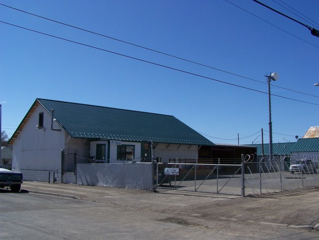
Property Record
225 W 6Th St, Elko, NV 89801

NEARBY LISTINGS FOR SALE OR LEASE
Property Detail
225 W 6Th St
Elko, NV
Elko (Town Of)
001-343-010
PARCEL 1 OF MAP FILE 752359,LOCATED IN,MDB&M,FORMERLY ASSESSED AS PARCEL 001-343-009 AND,001-343-010,NO HARD COPY RECORDS, AU
Commercialnec
Elko
AE
Nevada
32007C5609F
19
2024
0.35 AC
2025
Carson City/Nevada Area
951300
Other Market Areas
6,555 SF
DEMOGRAPHICS near 225 W 6Th St
1 Mile
3 Mile
5 Mile
2024 Total Population
9,448
24,524
25,995
2029 Population
9,713
25,148
26,663
Pop Growth 2024-2029
+ 2.80%
+ 2.54%
+ 2.57%
Average Age
36
36
36
2024 Total Households
3,863
9,367
9,911
HH Growth 2024-2029
+ 2.80%
+ 2.52%
+ 2.54%
Median Household Inc
$64,144
$84,200
$85,009
Avg Household Size
2.40
2.60
2.60
2024 Avg HH Vehicles
2.00
2.00
2.00
Median Home Value
$250,460
$291,070
$286,310
Median Year Built
1973
1986
1986
Nearby Places
Map Layers
Map Styles
 Street
 Aerial
- Restaurants
- Banks
- Shops
- Fitness
- Groceries
SALE & LEASE HISTORY
LISTING DATE
SALE/LEASE

Oct 01, 2024
For Lease
Nearby Properties
Address
Land Use
TOTAL SIZE
Lot Size
Zoning
Address
Land Use
TOTAL SIZE
Lot Size
Zoning
120,451 SF
45 AC
ZPC
Address
Land Use
TOTAL SIZE
Lot Size
Zoning
47,730 SF
479.29 AC
MULT
Address
Land Use
TOTAL SIZE
Lot Size
Zoning
215,373 SF
14.03 AC
ZPQP
Address
Land Use
TOTAL SIZE
Lot Size
Zoning
222,607 SF
10.39 AC
ZC
Address
Land Use
TOTAL SIZE
Lot Size
Zoning
14.71 AC
ZLI
Address
Land Use
TOTAL SIZE
Lot Size
Zoning
107,153 SF
53.50 AC
ZPQP
Address
Land Use
TOTAL SIZE
Lot Size
Zoning
184,595 SF
10.79 AC
ZR
Address
Land Use
TOTAL SIZE
Lot Size
Zoning
212,789 SF
22.72 AC
ZC
Address
Land Use
TOTAL SIZE
Lot Size
Zoning
23,552 SF
78.93 AC
MULT
Address
Land Use
TOTAL SIZE
Lot Size
Zoning
146,208 SF
36.18 AC
MULT
Address
Land Use
TOTAL SIZE
Lot Size
Zoning
162,124 SF
13.60 AC
ZIBP
Address
Land Use
TOTAL SIZE
Lot Size
Zoning
89,473 SF
10.47 AC
ZC
Address
Land Use
TOTAL SIZE
Lot Size
Zoning
1,253 SF
4 AC
ZR
Address
Land Use
TOTAL SIZE
Lot Size
Zoning
105,625 SF
11.18 AC
ZC
Address
Land Use
TOTAL SIZE
Lot Size
Zoning
57,884 SF
1.89 AC
ZC
Address
Land Use
TOTAL SIZE
Lot Size
Zoning
54,982 SF
2.17 AC
ZC
Address
Land Use
TOTAL SIZE
Lot Size
Zoning
53,073 SF
2.32 AC
ZC
Address
Land Use
TOTAL SIZE
Lot Size
Zoning
3,234 SF
5.38 AC
ZC
Address
Land Use
TOTAL SIZE
Lot Size
Zoning
59,525 SF
5.91 AC
ZC
Address
Land Use
TOTAL SIZE
Lot Size
Zoning
166,621 SF
1.40 AC
ZC
Address
Land Use
TOTAL SIZE
Lot Size
Zoning
29,193 SF
3.47 AC
ZPQP
Address
Land Use
TOTAL SIZE
Lot Size
Zoning
43,470 SF
1.82 AC
ZC
Address
Land Use
TOTAL SIZE
Lot Size
Zoning
57,628 SF
2.79 AC
ZC
Address
Land Use
TOTAL SIZE
Lot Size
Zoning
53,002 SF
3.11 AC
ZC
Address
Land Use
TOTAL SIZE
Lot Size
Zoning
96,349 SF
6.49 AC
ZC
Address
Land Use
TOTAL SIZE
Lot Size
Zoning
49,124 SF
1.50 AC
ZC
Address
Land Use
TOTAL SIZE
Lot Size
Zoning
32,520 SF
2.29 AC
ZLI
Address
Land Use
TOTAL SIZE
Lot Size
Zoning
36,897 SF
2.57 AC
ZPQP
Address
Land Use
TOTAL SIZE
Lot Size
Zoning
36,717 SF
3.49 AC
ZC
Address
Land Use
TOTAL SIZE
Lot Size
Zoning
98,533 SF
6.66 AC
MULT
The World's #1 Commercial Real Estate Marketplace
Connect with us
© 2026 CoStar Group
The information above has been obtained from sources believed reliable. While we do not doubt its accuracy we have not verified it and make no guarantee, warranty or representation about it. It is your responsibility to independently confirm its accuracy and completeness. Any projections, opinions, assumptions, or estimates used are for example only and do not represent the current or future performance of the property. The value of this transaction to you depends on tax and other factors which should be evaluated by your tax, financial, and legal advisors. You and your advisors should conduct a careful, independent investigation of the property to determine to your satisfaction the suitability of the property for your needs.