Property Record
2250 E 1St St, Grimes, IA 50111

Property Detail
2250 E 1St St
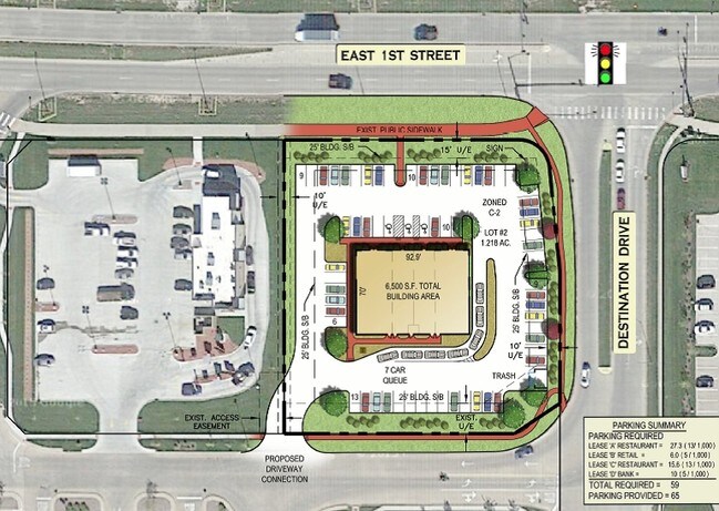
311-01401012000
LOT 2 WAL-MARTS SECOND ADDITION
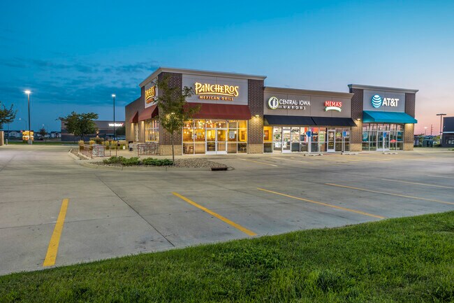
Regionalshoppingcenterormallwithanchorstore
Polk
C-2
Iowa
B and X Area of moderate flood hazard, usually the area between the limits of the 100-year and 500-year floods.
2
2024
1.22 AC
2025
Western Suburbs
011303
Des Moines
6,510 SF
Des Moines-West Des Moines, IA
NEARBY LISTINGS FOR SALE OR LEASE
DEMOGRAPHICS near 2250 E 1St St
1 mile
3 mile
5 mile
2025 Total Population
6,557
32,878
79,921
2030 Population
6,964
34,522
84,092
Pop Growth 2025-2030
+ 6.21%
+ 5.00%
+ 5.22%
Average Age
34
36
39
2025 Total Households
2,574
12,133
30,468
HH Growth 2025-2030
+ 6.22%
+ 5.13%
+ 5.30%
Median Household Inc
$93,716
$120,727
$110,423
Avg Household Size
2.50
2.70
2.60
2025 Avg HH Vehicles
2.00
2.00
2.00
Median Home Value
$342,446
$358,957
$345,125
Median Year Built
2010
2006
2000
Nearby Places
Map Layers
Map Styles
 Street
 Aerial
Layers
 Traffic
 Biking
Places
Listings with unknown addresses are not visible on the map
- Restaurants
- Banks
- Shops
- Fitness
- Groceries
PUBLIC TRANSPORTATION
AIRPORT
Des Moines International
Drive
Walk
Distance
Des Moines International
30 min
17.1 mi
SALE & LEASE HISTORY
LISTING DATE
SALE/LEASE

Sep 25, 2016
For Lease
Oct 01, 2024
For Lease
Mar 14, 2017
For Lease
Jun 06, 2018
For Lease
Jan 04, 2018
For Lease
Nearby Properties
Address
Land Use
TOTAL SIZE
Lot Size
Zoning
Address
Land Use
TOTAL SIZE
Lot Size
Zoning
486,792 SF
38.70 AC
PC
Address
Land Use
TOTAL SIZE
Lot Size
Zoning
627,104 SF
40.09 AC
Address
Land Use
TOTAL SIZE
Lot Size
Zoning
330,704 SF
15.86 AC
Address
Land Use
TOTAL SIZE
Lot Size
Zoning
386,976 SF
30 AC
Address
Land Use
TOTAL SIZE
Lot Size
Zoning
59,496 SF
9.34 AC
Address
Land Use
TOTAL SIZE
Lot Size
Zoning
197,658 SF
15.91 AC
Address
Land Use
TOTAL SIZE
Lot Size
Zoning
184,658 SF
14.61 AC
Address
Land Use
TOTAL SIZE
Lot Size
Zoning
300,000 SF
17.51 AC
Address
Land Use
TOTAL SIZE
Lot Size
Zoning
270,000 SF
19.10 AC
Address
Land Use
TOTAL SIZE
Lot Size
Zoning
133,256 SF
15.93 AC
Address
Land Use
TOTAL SIZE
Lot Size
Zoning
260,000 SF
14.32 AC
Address
Land Use
TOTAL SIZE
Lot Size
Zoning
269,700 SF
16.53 AC
Address
Land Use
TOTAL SIZE
Lot Size
Zoning
166,160 SF
11.88 AC
Address
Land Use
TOTAL SIZE
Lot Size
Zoning
287,228 SF
27.32 AC
A-R
Address
Land Use
TOTAL SIZE
Lot Size
Zoning
260,000 SF
18.45 AC
Address
Land Use
TOTAL SIZE
Lot Size
Zoning
235,422 SF
13.39 AC
Address
Land Use
TOTAL SIZE
Lot Size
Zoning
250,000 SF
13.93 AC
Address
Land Use
TOTAL SIZE
Lot Size
Zoning
245,520 SF
19.33 AC
Address
Land Use
TOTAL SIZE
Lot Size
Zoning
77.75 AC
Address
Land Use
TOTAL SIZE
Lot Size
Zoning
212,500 SF
10.20 AC
Address
Land Use
TOTAL SIZE
Lot Size
Zoning
127,869 SF
6.70 AC
Address
Land Use
TOTAL SIZE
Lot Size
Zoning
35.81 AC
Address
Land Use
TOTAL SIZE
Lot Size
Zoning
219,950 SF
22.57 AC
Address
Land Use
TOTAL SIZE
Lot Size
Zoning
200,000 SF
14.57 AC
Address
Land Use
TOTAL SIZE
Lot Size
Zoning
181,984 SF
16.42 AC
Address
Land Use
TOTAL SIZE
Lot Size
Zoning
91,733 SF
13 AC
Address
Land Use
TOTAL SIZE
Lot Size
Zoning
187,816 SF
21.51 AC
M-2
Address
Land Use
TOTAL SIZE
Lot Size
Zoning
84,315 SF
20.59 AC
M2
Address
Land Use
TOTAL SIZE
Lot Size
Zoning
213,835 SF
15.93 AC
PUD
Address
Land Use
TOTAL SIZE
Lot Size
Zoning
187,896 SF
18.91 AC
PUD
The World's #1 Commercial Real Estate Marketplace
Connect with us
© 2026 CoStar Group
The information above has been obtained from sources believed reliable. While we do not doubt its accuracy we have not verified it and make no guarantee, warranty or representation about it. It is your responsibility to independently confirm its accuracy and completeness. Any projections, opinions, assumptions, or estimates used are for example only and do not represent the current or future performance of the property. The value of this transaction to you depends on tax and other factors which should be evaluated by your tax, financial, and legal advisors. You and your advisors should conduct a careful, independent investigation of the property to determine to your satisfaction the suitability of the property for your needs.