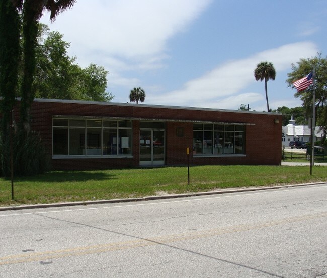
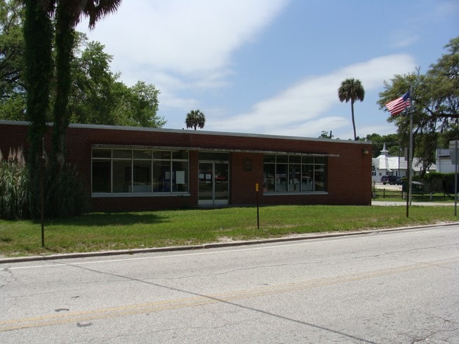
Property Record
2250 E Highway 318, Citra, FL 32113


Property Detail
2250 E Highway 318
03492-000-00
SEC 28 TWP 12 RGE 22 PLAT BOOK E PAGE 038 TOWN OF CITRA BLK 9 LOT 1 A PT OF BEING MORE PARTICULARLY DESC AS: COM AT THE NE COR LOT 1 BLK 9 TH W 70 FT TO THE POB TH S 201.06 FT TO A PT 195 FT N OF THE S BNDY OF BLK 9 TH W 140 FT TH N 201.06 FT TH E 14
Federalproperty
Marion
B4
Florida
B and X Area of moderate flood hazard, usually the area between the limits of the 100-year and 500-year floods.
1
2025
0.65 AC
2025
Outlying Marion County
000201
Ocala
3,360 SF
Ocala, FL
NEARBY LISTINGS FOR SALE OR LEASE
DEMOGRAPHICS near 2250 E Highway 318
1 mile
3 mile
5 mile
2025 Total Population
569
4,017
7,160
2030 Population
641
4,581
8,123
Pop Growth 2025-2030
+ 12.65%
+ 14.04%
+ 13.45%
Average Age
43
43
44
2025 Total Households
229
1,617
2,928
HH Growth 2025-2030
+ 13.10%
+ 14.22%
+ 13.63%
Median Household Inc
$43,958
$64,047
$63,820
Avg Household Size
2.40
2.40
2.40
2025 Avg HH Vehicles
2.00
2.00
2.00
Median Home Value
$414,179
$336,842
$306,609
Median Year Built
1984
1987
1987
Nearby Places
Map Layers
Map Styles
 Street
 Aerial
Layers
 Traffic
 Biking
Places
Listings with unknown addresses are not visible on the map
- Restaurants
- Banks
- Shops
- Fitness
- Groceries
PUBLIC TRANSPORTATION
AIRPORT
Gainesville Regional
Drive
Walk
Distance
Gainesville Regional
45 min
31.7 mi
SALE & LEASE HISTORY
LISTING DATE
SALE/LEASE

Sep 23, 2016
For Sale
Dec 20, 2016
For Sale
Nearby Properties
Address
Land Use
TOTAL SIZE
Lot Size
Zoning
Address
Land Use
TOTAL SIZE
Lot Size
Zoning
91,144 SF
30.19 AC
A1
Address
Land Use
TOTAL SIZE
Lot Size
Zoning
40,022 SF
61 AC
A1
Address
Land Use
TOTAL SIZE
Lot Size
Zoning
320 AC
A1
Address
Land Use
TOTAL SIZE
Lot Size
Zoning
12,691 SF
2.26 AC
B4
Address
Land Use
TOTAL SIZE
Lot Size
Zoning
21,000 SF
8.95 AC
B4
Address
Land Use
TOTAL SIZE
Lot Size
Zoning
768 SF
6.26 AC
RR
Address
Land Use
TOTAL SIZE
Lot Size
Zoning
12,500 SF
7.75 AC
B5
Address
Land Use
TOTAL SIZE
Lot Size
Zoning
22,080 SF
3.05 AC
B4
Address
Land Use
TOTAL SIZE
Lot Size
Zoning
8,381 SF
1.82 AC
A1
Address
Land Use
TOTAL SIZE
Lot Size
Zoning
7,131 SF
294 AC
A1
Address
Land Use
TOTAL SIZE
Lot Size
Zoning
8,320 SF
1.09 AC
B4
Address
Land Use
TOTAL SIZE
Lot Size
Zoning
4,242 SF
25.77 AC
A1
Address
Land Use
TOTAL SIZE
Lot Size
Zoning
5,400 SF
3 AC
B2
Address
Land Use
TOTAL SIZE
Lot Size
Zoning
5,474 SF
6.45 AC
RC1
Address
Land Use
TOTAL SIZE
Lot Size
Zoning
5,225 SF
560.95 AC
A1
Address
Land Use
TOTAL SIZE
Lot Size
Zoning
4,965 SF
1.53 AC
B4
Address
Land Use
TOTAL SIZE
Lot Size
Zoning
6,158 SF
3.50 AC
B4
Address
Land Use
TOTAL SIZE
Lot Size
Zoning
3,360 SF
0.65 AC
B4
Address
Land Use
TOTAL SIZE
Lot Size
Zoning
6,224 SF
10 AC
M1
Address
Land Use
TOTAL SIZE
Lot Size
Zoning
8,000 SF
1 AC
B4
Address
Land Use
TOTAL SIZE
Lot Size
Zoning
1,148 SF
10.10 AC
A1
Address
Land Use
TOTAL SIZE
Lot Size
Zoning
2,440 SF
1.59 AC
BH
Address
Land Use
TOTAL SIZE
Lot Size
Zoning
10,550 SF
4.07 AC
B4
Address
Land Use
TOTAL SIZE
Lot Size
Zoning
2,060 SF
9.22 AC
A1
Address
Land Use
TOTAL SIZE
Lot Size
Zoning
6,238 SF
2.38 AC
B4
Address
Land Use
TOTAL SIZE
Lot Size
Zoning
1,044 SF
3.32 AC
PRV
Address
Land Use
TOTAL SIZE
Lot Size
Zoning
3,242 SF
3.30 AC
B4
Address
Land Use
TOTAL SIZE
Lot Size
Zoning
5,593 SF
4.11 AC
A1
Address
Land Use
TOTAL SIZE
Lot Size
Zoning
5,900 SF
65.09 AC
A1
The World's #1 Commercial Real Estate Marketplace
Connect with us
© 2026 CoStar Group
The information above has been obtained from sources believed reliable. While we do not doubt its accuracy we have not verified it and make no guarantee, warranty or representation about it. It is your responsibility to independently confirm its accuracy and completeness. Any projections, opinions, assumptions, or estimates used are for example only and do not represent the current or future performance of the property. The value of this transaction to you depends on tax and other factors which should be evaluated by your tax, financial, and legal advisors. You and your advisors should conduct a careful, independent investigation of the property to determine to your satisfaction the suitability of the property for your needs.