Property Record
22502 Woodroe Ave, Hayward, CA 94541

NEARBY LISTINGS FOR SALE OR LEASE
Property Detail
22502 Woodroe Ave
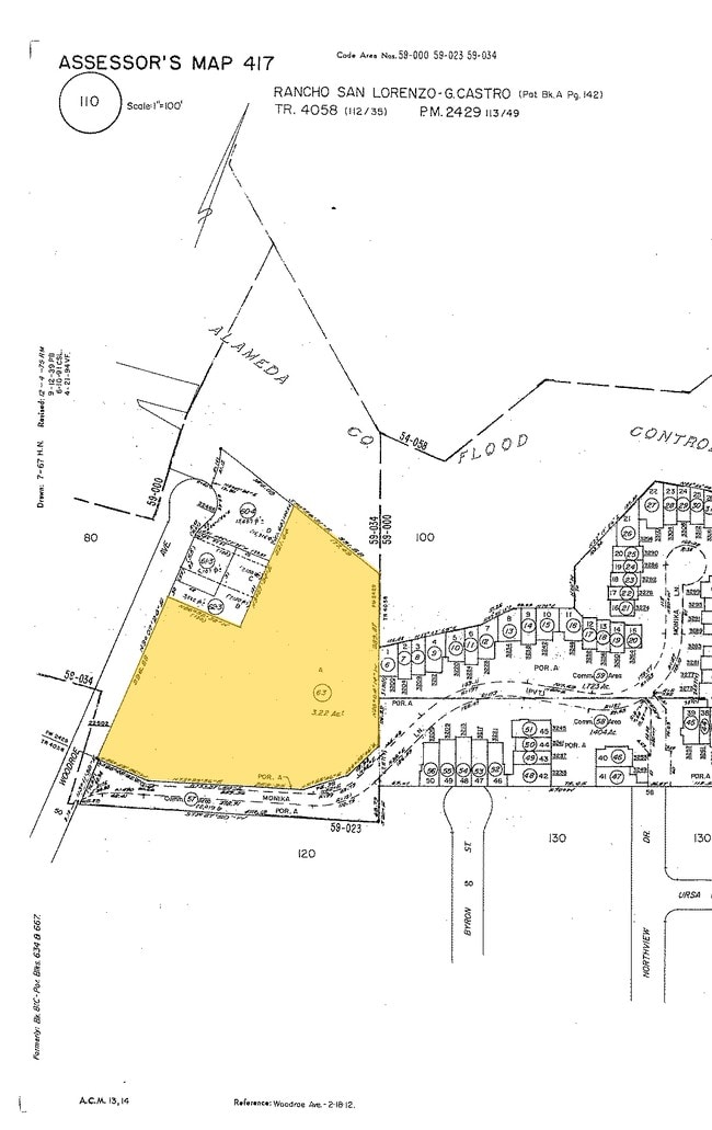
417-0110-063-00
Parcel Map 2429
Publicschool
LOT: 0000A BLK: PM: 0113 PAGE: 0049
X
Alameda
06001C0285G
California
2024
3.22 AC
2025
Hayward/Castro Valley
435200
East Bay/Oakland
11,209 SF
Oakland-Hayward-Berkeley, CA
DEMOGRAPHICS near 22502 Woodroe Ave
1 Mile
3 Mile
5 Mile
2024 Total Population
19,230
130,359
300,630
2029 Population
18,596
126,128
290,694
Pop Growth 2024-2029
(3.30%)
(3.25%)
(3.31%)
Average Age
41
40
40
2024 Total Households
6,568
44,171
96,896
HH Growth 2024-2029
(3.52%)
(3.42%)
(3.50%)
Median Household Inc
$112,905
$108,919
$98,229
Avg Household Size
2.80
2.80
3.00
2024 Avg HH Vehicles
2.00
2.00
2.00
Median Home Value
$837,895
$851,905
$781,491
Median Year Built
1971
1969
1968
Nearby Places
Map Layers
Map Styles
 Street
 Aerial
- Restaurants
- Banks
- Shops
- Fitness
- Groceries
PUBLIC TRANSPORTATION
COMMUTER RAIL
Hayward Amtrak (Capitol Corridor - Amtrak)
DRIVE
WALK
Distance
Hayward Amtrak (Capitol Corridor - Amtrak)
9 min
3.3 mi
Hayward (Capitol Corridor - Capitol Corridor Joint Powers Authority)
DRIVE
WALK
Distance
Hayward (Capitol Corridor - Capitol Corridor Joint Powers Authority)
9 min
3.3 mi
AIRPORT
Metro Oakland International
DRIVE
WALK
Distance
Metro Oakland International
20 min
12.3 mi
San Francisco International
DRIVE
WALK
Distance
San Francisco International
37 min
25.3 mi
Norman Y Mineta San Jose International
DRIVE
WALK
Distance
Norman Y Mineta San Jose International
42 min
29.8 mi
Freight Ports
Port of Oakland
DRIVE
WALK
Distance
Port of Oakland
25 min
16.9 mi
Nearby Properties
Address
Land Use
TOTAL SIZE
Lot Size
Zoning
Address
Land Use
TOTAL SIZE
Lot Size
Zoning
4.90 AC
Address
Land Use
TOTAL SIZE
Lot Size
Zoning
2.48 AC
Address
Land Use
TOTAL SIZE
Lot Size
Zoning
470,929 SF
31.62 AC
Address
Land Use
TOTAL SIZE
Lot Size
Zoning
1.50 AC
Address
Land Use
TOTAL SIZE
Lot Size
Zoning
187,926 SF
1.19 AC
Address
Land Use
TOTAL SIZE
Lot Size
Zoning
310,072 SF
14.96 AC
Address
Land Use
TOTAL SIZE
Lot Size
Zoning
228,736 SF
5.95 AC
Address
Land Use
TOTAL SIZE
Lot Size
Zoning
169,371 SF
4.63 AC
Address
Land Use
TOTAL SIZE
Lot Size
Zoning
119,800 SF
5.72 AC
Address
Land Use
TOTAL SIZE
Lot Size
Zoning
57,497 SF
4.92 AC
Address
Land Use
TOTAL SIZE
Lot Size
Zoning
92,534 SF
3.04 AC
Address
Land Use
TOTAL SIZE
Lot Size
Zoning
137,422 SF
5.56 AC
RH
Address
Land Use
TOTAL SIZE
Lot Size
Zoning
94,485 SF
8.31 AC
Address
Land Use
TOTAL SIZE
Lot Size
Zoning
Address
Land Use
TOTAL SIZE
Lot Size
Zoning
25,000 SF
1.24 AC
Address
Land Use
TOTAL SIZE
Lot Size
Zoning
42,359 SF
3.79 AC
Address
Land Use
TOTAL SIZE
Lot Size
Zoning
61,355 SF
4.31 AC
Address
Land Use
TOTAL SIZE
Lot Size
Zoning
52,110 SF
2.06 AC
Address
Land Use
TOTAL SIZE
Lot Size
Zoning
56,410 SF
5.01 AC
Address
Land Use
TOTAL SIZE
Lot Size
Zoning
46,540 SF
2.92 AC
R5D
Address
Land Use
TOTAL SIZE
Lot Size
Zoning
78,326 SF
6.88 AC
Address
Land Use
TOTAL SIZE
Lot Size
Zoning
138,960 SF
2.62 AC
Address
Land Use
TOTAL SIZE
Lot Size
Zoning
5,688 SF
1.36 AC
Address
Land Use
TOTAL SIZE
Lot Size
Zoning
67,434 SF
3.68 AC
Address
Land Use
TOTAL SIZE
Lot Size
Zoning
48,998 SF
3.28 AC
Address
Land Use
TOTAL SIZE
Lot Size
Zoning
61,578 SF
2.53 AC
Address
Land Use
TOTAL SIZE
Lot Size
Zoning
44,796 SF
2.14 AC
Address
Land Use
TOTAL SIZE
Lot Size
Zoning
40,385 SF
1.42 AC
Address
Land Use
TOTAL SIZE
Lot Size
Zoning
3,499 SF
0.51 AC
Address
Land Use
TOTAL SIZE
Lot Size
Zoning
27,884 SF
0.91 AC
The World's #1 Commercial Real Estate Marketplace
Connect with us
© 2026 CoStar Group
The information above has been obtained from sources believed reliable. While we do not doubt its accuracy we have not verified it and make no guarantee, warranty or representation about it. It is your responsibility to independently confirm its accuracy and completeness. Any projections, opinions, assumptions, or estimates used are for example only and do not represent the current or future performance of the property. The value of this transaction to you depends on tax and other factors which should be evaluated by your tax, financial, and legal advisors. You and your advisors should conduct a careful, independent investigation of the property to determine to your satisfaction the suitability of the property for your needs.