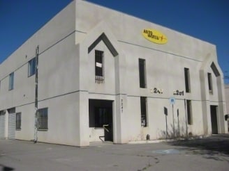
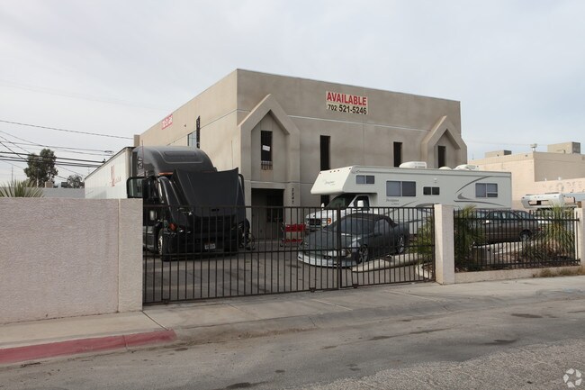
Property Record
2251 Crestline Loop, North Las Vegas, NV 89030

Property Detail
2251 Crestline Loop
139-22-502-003
PT NW4 NE4 SEC 22 20 61
Shipyard
Clark
M2
Nevada
B and X Area of moderate flood hazard, usually the area between the limits of the 100-year and 500-year floods.
0.28 AC
2026
North Las Vegas
2026
Las Vegas
003700
Las Vegas-Henderson-North Las Vegas, NV
4,928 SF
NEARBY LISTINGS FOR SALE OR LEASE
DEMOGRAPHICS near 2251 Crestline Loop
1 mile
3 mile
5 mile
2025 Total Population
20,337
186,501
509,749
2030 Population
21,339
195,083
534,426
Pop Growth 2025-2030
+ 4.93%
+ 4.60%
+ 4.84%
Average Age
36
36
37
2025 Total Households
6,256
59,950
171,462
HH Growth 2025-2030
+ 5.07%
+ 4.78%
+ 5.02%
Median Household Inc
$38,126
$48,601
$56,176
Avg Household Size
3.00
2.90
2.80
2025 Avg HH Vehicles
1.00
2.00
2.00
Median Home Value
$272,634
$313,211
$346,809
Median Year Built
1976
1984
1988
Nearby Places
Map Layers
Map Styles
 Street
 Aerial
Layers
 Traffic
 Biking
Places
Listings with unknown addresses are not visible on the map
- Restaurants
- Banks
- Shops
- Fitness
- Groceries
PUBLIC TRANSPORTATION
AIRPORT
Harry Reid International
Drive
Walk
Distance
Harry Reid International
18 min
10.5 mi
Boulder City Municipal
Drive
Walk
Distance
Boulder City Municipal
38 min
28.3 mi
SALE & LEASE HISTORY
LISTING DATE
SALE/LEASE

May 31, 2023
For Sale
May 25, 2017
For Sale
Jun 19, 2017
For Sale
Jun 05, 2023
For Sale
Jul 27, 2017
For Sale
Jan 07, 2021
For Sale
Feb 06, 2022
For Sale
Nearby Properties
Address
Land Use
TOTAL SIZE
Lot Size
Zoning
Address
Land Use
TOTAL SIZE
Lot Size
Zoning
315,865 SF
19.85 AC
Address
Land Use
TOTAL SIZE
Lot Size
Zoning
79,707 SF
2.76 AC
Address
Land Use
TOTAL SIZE
Lot Size
Zoning
39,972 SF
3.04 AC
CV
Address
Land Use
TOTAL SIZE
Lot Size
Zoning
162,501 SF
5.77 AC
C2
Address
Land Use
TOTAL SIZE
Lot Size
Zoning
18,125 SF
2.14 AC
Address
Land Use
TOTAL SIZE
Lot Size
Zoning
1,767,948 SF
142.04 AC
Address
Land Use
TOTAL SIZE
Lot Size
Zoning
1,617,320 SF
7.21 AC
PD
Address
Land Use
TOTAL SIZE
Lot Size
Zoning
2.79 AC
CV
Address
Land Use
TOTAL SIZE
Lot Size
Zoning
5.96 AC
C2
Address
Land Use
TOTAL SIZE
Lot Size
Zoning
1,283,663 SF
8.56 AC
PD
Address
Land Use
TOTAL SIZE
Lot Size
Zoning
44,418 SF
5.08 AC
PD
Address
Land Use
TOTAL SIZE
Lot Size
Zoning
573,491 SF
38.94 AC
Address
Land Use
TOTAL SIZE
Lot Size
Zoning
34.83 AC
CV
Address
Land Use
TOTAL SIZE
Lot Size
Zoning
814,789 SF
13.75 AC
C1
Address
Land Use
TOTAL SIZE
Lot Size
Zoning
252,005 SF
27.94 AC
C3
Address
Land Use
TOTAL SIZE
Lot Size
Zoning
123,990 SF
2.18 AC
C2
Address
Land Use
TOTAL SIZE
Lot Size
Zoning
38.80 AC
CV
Address
Land Use
TOTAL SIZE
Lot Size
Zoning
724,845 SF
37.33 AC
M2
Address
Land Use
TOTAL SIZE
Lot Size
Zoning
51.45 AC
R1
Address
Land Use
TOTAL SIZE
Lot Size
Zoning
23,901 SF
5.25 AC
PD
Address
Land Use
TOTAL SIZE
Lot Size
Zoning
324 SF
8.74 AC
R1
Address
Land Use
TOTAL SIZE
Lot Size
Zoning
617,670 SF
27.90 AC
M2
Address
Land Use
TOTAL SIZE
Lot Size
Zoning
1,608 SF
30.32 AC
RAPSP
Address
Land Use
TOTAL SIZE
Lot Size
Zoning
8.96 AC
L:PD
Address
Land Use
TOTAL SIZE
Lot Size
Zoning
53,435 SF
2.98 AC
C2
Address
Land Use
TOTAL SIZE
Lot Size
Zoning
16,004 SF
4.19 AC
Address
Land Use
TOTAL SIZE
Lot Size
Zoning
191,879 SF
12 AC
RACHE
The World's #1 Commercial Real Estate Marketplace
Connect with us
© 2026 CoStar Group
The information above has been obtained from sources believed reliable. While we do not doubt its accuracy we have not verified it and make no guarantee, warranty or representation about it. It is your responsibility to independently confirm its accuracy and completeness. Any projections, opinions, assumptions, or estimates used are for example only and do not represent the current or future performance of the property. The value of this transaction to you depends on tax and other factors which should be evaluated by your tax, financial, and legal advisors. You and your advisors should conduct a careful, independent investigation of the property to determine to your satisfaction the suitability of the property for your needs.