Property Record
22529 Parsons Cir, Cape Charles, VA 23310
NEARBY LISTINGS FOR SALE OR LEASE
-
-
View all Cape Charles listings for sale on LoopNet.com
Property Detail
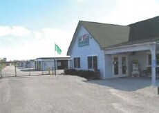
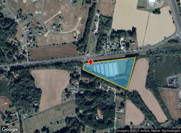
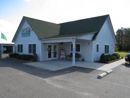
22529 Parsons Cir
Officebuilding
9 AC NR CAPE CHARLES
X
Northampton
51131C0315F
Virginia
2024
9 AC
2024
Virginia Regional
930301
Other Market Areas
1,120 SF
84-A-92B
DEMOGRAPHICS near 22529 Parsons Cir
1 Mile
3 Mile
5 Mile
2024 Total Population
480
4,222
5,372
2029 Population
478
4,274
5,364
Pop Growth 2024-2029
(0.42%)
+ 1.23%
(0.15%)
Average Age
50
49
48
2024 Total Households
228
2,004
2,484
HH Growth 2024-2029
0.00%
+ 1.50%
+ 0.20%
Median Household Inc
$46,389
$47,153
$48,939
Avg Household Size
2.00
2.10
2.10
2024 Avg HH Vehicles
2.00
2.00
2.00
Median Home Value
$304,054
$336,377
$317,939
Median Year Built
2000
1985
1985
Nearby Places
Map Layers
Map Styles
 Street
 Aerial
- Restaurants
- Banks
- Shops
- Fitness
- Groceries
PUBLIC TRANSPORTATION
AIRPORT
Norfolk International
DRIVE
WALK
Distance
Norfolk International
56 min
37.2 mi
Freight Ports
Virginia Port Authority - Norfolk
DRIVE
WALK
Distance
Virginia Port Authority - Norfolk
67 min
42.2 mi
Nearby Properties
Address
Land Use
TOTAL SIZE
Lot Size
Zoning
Address
Land Use
TOTAL SIZE
Lot Size
Zoning
Address
Land Use
TOTAL SIZE
Lot Size
Zoning
17.05 AC
Address
Land Use
TOTAL SIZE
Lot Size
Zoning
Address
Land Use
TOTAL SIZE
Lot Size
Zoning
Address
Land Use
TOTAL SIZE
Lot Size
Zoning
95.61 AC
LU
Address
Land Use
TOTAL SIZE
Lot Size
Zoning
Address
Land Use
TOTAL SIZE
Lot Size
Zoning
40.82 AC
Address
Land Use
TOTAL SIZE
Lot Size
Zoning
Address
Land Use
TOTAL SIZE
Lot Size
Zoning
18.40 AC
Address
Land Use
TOTAL SIZE
Lot Size
Zoning
0.37 AC
Address
Land Use
TOTAL SIZE
Lot Size
Zoning
5,124 SF
0.46 AC
Address
Land Use
TOTAL SIZE
Lot Size
Zoning
4,436 SF
0.26 AC
Address
Land Use
TOTAL SIZE
Lot Size
Zoning
4,722 SF
0.28 AC
Address
Land Use
TOTAL SIZE
Lot Size
Zoning
Address
Land Use
TOTAL SIZE
Lot Size
Zoning
5,344 SF
0.29 AC
Address
Land Use
TOTAL SIZE
Lot Size
Zoning
Address
Land Use
TOTAL SIZE
Lot Size
Zoning
7,486 SF
0.21 AC
Address
Land Use
TOTAL SIZE
Lot Size
Zoning
Address
Land Use
TOTAL SIZE
Lot Size
Zoning
6,096 SF
0.53 AC
Address
Land Use
TOTAL SIZE
Lot Size
Zoning
3,838 SF
0.28 AC
Address
Land Use
TOTAL SIZE
Lot Size
Zoning
6,000 SF
109.92 AC
LU
Address
Land Use
TOTAL SIZE
Lot Size
Zoning
38.59 AC
Address
Land Use
TOTAL SIZE
Lot Size
Zoning
Address
Land Use
TOTAL SIZE
Lot Size
Zoning
Address
Land Use
TOTAL SIZE
Lot Size
Zoning
Address
Land Use
TOTAL SIZE
Lot Size
Zoning
160 AC
AFD
Address
Land Use
TOTAL SIZE
Lot Size
Zoning
Address
Land Use
TOTAL SIZE
Lot Size
Zoning
5,588 SF
0.20 AC
The World's #1 Commercial Real Estate Marketplace
Connect with us
© 2025 CoStar Group
The information above has been obtained from sources believed reliable. While we do not doubt its accuracy we have not verified it and make no guarantee, warranty or representation about it. It is your responsibility to independently confirm its accuracy and completeness. Any projections, opinions, assumptions, or estimates used are for example only and do not represent the current or future performance of the property. The value of this transaction to you depends on tax and other factors which should be evaluated by your tax, financial, and legal advisors. You and your advisors should conduct a careful, independent investigation of the property to determine to your satisfaction the suitability of the property for your needs.