Property Record
2253 La Montana Way, Colorado Springs, CO 80918

Current Lease Availabilities
NEARBY LISTINGS FOR SALE OR LEASE
Property Detail
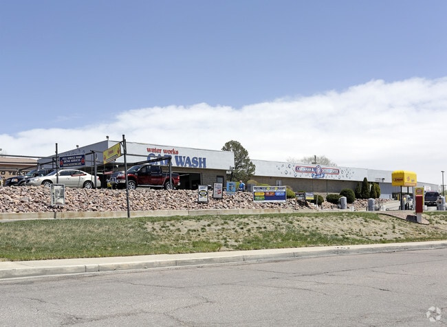
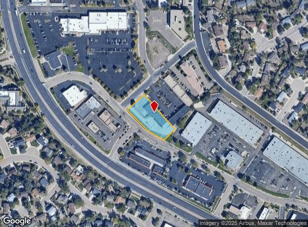
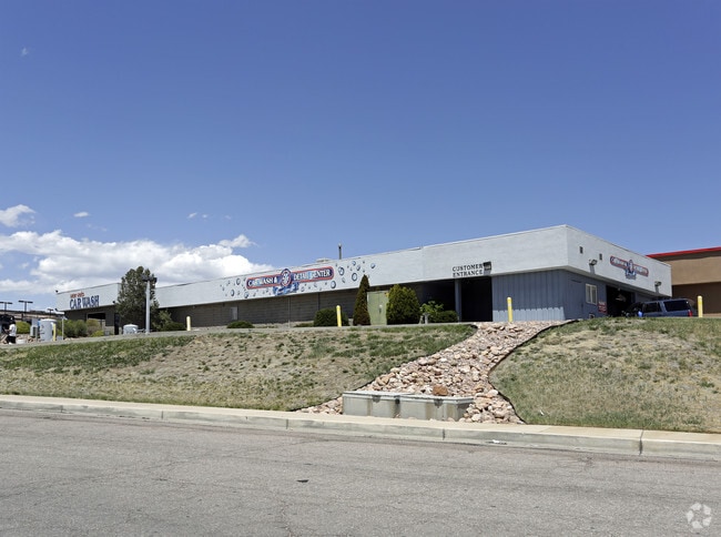
2253 La Montana Way
Colorado Springs, CO
Academy North Auto Plaza A Replat Of Lot
63212-11-004
LOT 2 ACADEMY NORTH AUTO PLAZA
Commercialnec
El Paso
X
Colorado
08041C0516G
2
2024
0.80 AC
2025
Northeast
004800
Colorado Springs
7,860 SF
DEMOGRAPHICS near 2253 La Montana Way
1 Mile
3 Mile
5 Mile
2024 Total Population
14,400
103,408
266,793
2029 Population
15,087
107,399
277,523
Pop Growth 2024-2029
+ 4.77%
+ 3.86%
+ 4.02%
Average Age
40
39
39
2024 Total Households
6,074
43,128
107,577
HH Growth 2024-2029
+ 5.00%
+ 4.07%
+ 4.24%
Median Household Inc
$74,907
$73,105
$79,385
Avg Household Size
2.30
2.30
2.40
2024 Avg HH Vehicles
2.00
2.00
2.00
Median Home Value
$386,326
$373,709
$387,287
Median Year Built
1981
1982
1984
Nearby Places
- Restaurants
- Banks
- Shops
- Fitness
- Groceries
PUBLIC TRANSPORTATION
AIRPORT
City of Colorado Springs Municipal
DRIVE
WALK
Distance
City of Colorado Springs Municipal
22 min
11.0 mi
Freight Ports
Tulsa Port Of Catoosa
DRIVE
WALK
Distance
Tulsa Port Of Catoosa
737 min
690.5 mi
Nearby Properties
Address
Land Use
TOTAL SIZE
Lot Size
Zoning
Address
Land Use
TOTAL SIZE
Lot Size
Zoning
62,201 SF
5.68 AC
MX-N
Address
Land Use
TOTAL SIZE
Lot Size
Zoning
167,120 SF
10.59 AC
MX-L/CR CU
Address
Land Use
TOTAL SIZE
Lot Size
Zoning
197,578 SF
7.98 AC
PDZ
Address
Land Use
TOTAL SIZE
Lot Size
Zoning
409,164 SF
19.26 AC
PUD
Address
Land Use
TOTAL SIZE
Lot Size
Zoning
109,808 SF
8.11 AC
MX-M
Address
Land Use
TOTAL SIZE
Lot Size
Zoning
131,545 SF
12.46 AC
R-5/CR CU
Address
Land Use
TOTAL SIZE
Lot Size
Zoning
86,020 SF
15.30 AC
R-1 6 CU H
Address
Land Use
TOTAL SIZE
Lot Size
Zoning
80,802 SF
14.45 AC
PF NNA
Address
Land Use
TOTAL SIZE
Lot Size
Zoning
80,110 SF
2.61 AC
OR CU
Address
Land Use
TOTAL SIZE
Lot Size
Zoning
83,441 SF
4.20 AC
MX-M/CR CU
Address
Land Use
TOTAL SIZE
Lot Size
Zoning
77,655 SF
8.39 AC
MX-N MX-N/
Address
Land Use
TOTAL SIZE
Lot Size
Zoning
1,223 SF
725.94 AC
PF PK SS
Address
Land Use
TOTAL SIZE
Lot Size
Zoning
89,592 SF
7.60 AC
R-E CU
Address
Land Use
TOTAL SIZE
Lot Size
Zoning
71,542 SF
10.11 AC
PF
Address
Land Use
TOTAL SIZE
Lot Size
Zoning
134,592 SF
10.09 AC
MX-L LI CU
Address
Land Use
TOTAL SIZE
Lot Size
Zoning
39,627 SF
1.61 AC
R-5 SS
Address
Land Use
TOTAL SIZE
Lot Size
Zoning
131,696 SF
9.24 AC
MX-M
Address
Land Use
TOTAL SIZE
Lot Size
Zoning
45,044 SF
2 AC
R-1 6
Address
Land Use
TOTAL SIZE
Lot Size
Zoning
48,117 SF
2.96 AC
MX-M CU
Address
Land Use
TOTAL SIZE
Lot Size
Zoning
34,443 SF
5.14 AC
PF
Address
Land Use
TOTAL SIZE
Lot Size
Zoning
104,162 SF
20.14 AC
R-1 6
Address
Land Use
TOTAL SIZE
Lot Size
Zoning
76,138 SF
4.84 AC
BP
Address
Land Use
TOTAL SIZE
Lot Size
Zoning
49,023 SF
5.68 AC
MX-L NNA
Address
Land Use
TOTAL SIZE
Lot Size
Zoning
45,141 SF
6.97 AC
R-5/CR
Address
Land Use
TOTAL SIZE
Lot Size
Zoning
83,479 SF
0.03 AC
OC HS ??
Address
Land Use
TOTAL SIZE
Lot Size
Zoning
62,127 SF
6.39 AC
MX-M/CR
Address
Land Use
TOTAL SIZE
Lot Size
Zoning
53,632 SF
3.42 AC
PF SS
Address
Land Use
TOTAL SIZE
Lot Size
Zoning
158,502 SF
5.73 AC
MX-N HS
Address
Land Use
TOTAL SIZE
Lot Size
Zoning
23,431 SF
0.17 AC
R-E MX-M P
Address
Land Use
TOTAL SIZE
Lot Size
Zoning
23,324 SF
7.84 AC
MX-N CU
The World's #1 Commercial Real Estate Marketplace
Connect with us
© 2025 CoStar Group
The information above has been obtained from sources believed reliable. While we do not doubt its accuracy we have not verified it and make no guarantee, warranty or representation about it. It is your responsibility to independently confirm its accuracy and completeness. Any projections, opinions, assumptions, or estimates used are for example only and do not represent the current or future performance of the property. The value of this transaction to you depends on tax and other factors which should be evaluated by your tax, financial, and legal advisors. You and your advisors should conduct a careful, independent investigation of the property to determine to your satisfaction the suitability of the property for your needs.