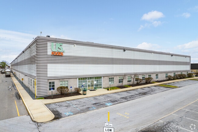
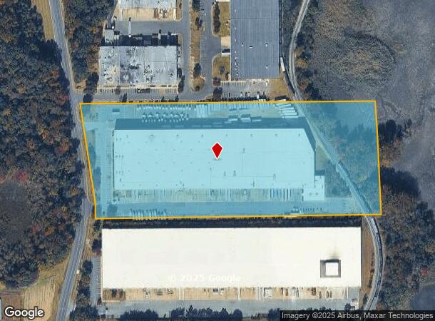
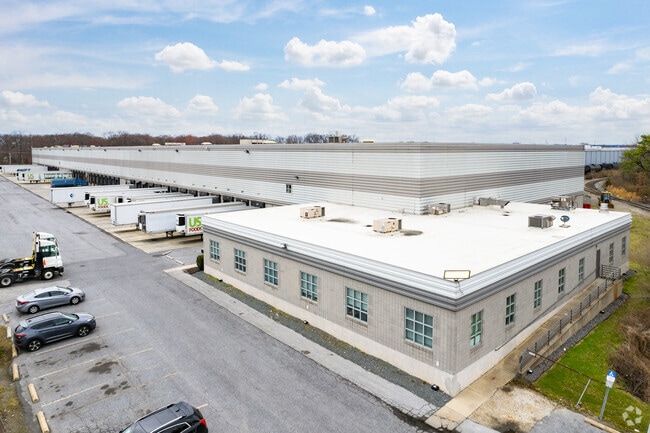
Property Record
2255 High Hill Rd, Swedesboro, NJ 08085
NEARBY LISTINGS FOR SALE OR LEASE
Property Detail
2255 High Hill Rd
09-01602-0000-00022
Gloucester
Warehouse
New Jersey
AE
22
34015C0061F
13.51 AC
2024
Gloucester County
2025
Philadelphia
502201
Philadelphia-Camden-Wilmington, PA-NJ-DE-MD
2,219 SF
DEMOGRAPHICS near 2255 High Hill Rd
1 Mile
3 Mile
5 Mile
2024 Total Population
84
10,942
57,196
2029 Population
88
11,343
58,575
Pop Growth 2024-2029
+ 4.76%
+ 3.66%
+ 2.41%
Average Age
37
40
38
2024 Total Households
23
3,892
20,544
HH Growth 2024-2029
0.00%
+ 3.96%
+ 2.45%
Median Household Inc
$133,333
$127,360
$59,638
Avg Household Size
3.40
2.80
2.70
2024 Avg HH Vehicles
2.00
2.00
2.00
Median Home Value
$199,999
$293,318
$213,333
Median Year Built
1971
1993
1964
Nearby Places
Map Layers
Map Styles
 Street
 Aerial
- Restaurants
- Banks
- Shops
- Fitness
- Groceries
PUBLIC TRANSPORTATION
COMMUTER RAIL
Highland Avenue (R2 - Southeastern Pennsylvania Transportation Authority Regional Rail (SEPTA Regional Rail))
DRIVE
WALK
Distance
Highland Avenue (R2 - Southeastern Pennsylvania Transportation Authority Regional Rail (SEPTA Regional Rail))
13 min
6.8 mi
Marcus Hook (R2 - Southeastern Pennsylvania Transportation Authority Regional Rail (SEPTA Regional Rail))
DRIVE
WALK
Distance
Marcus Hook (R2 - Southeastern Pennsylvania Transportation Authority Regional Rail (SEPTA Regional Rail))
17 min
8.4 mi
AIRPORT
Philadelphia International
DRIVE
WALK
Distance
Philadelphia International
25 min
14.6 mi
Freight Ports
Port of Wilmington, RI
DRIVE
WALK
Distance
Port of Wilmington, RI
30 min
17.8 mi
Nearby Properties
Address
Land Use
TOTAL SIZE
Lot Size
Zoning
Address
Land Use
TOTAL SIZE
Lot Size
Zoning
11,013 SF
209.88 AC
RCC
Address
Land Use
TOTAL SIZE
Lot Size
Zoning
66.85 AC
R5
Address
Land Use
TOTAL SIZE
Lot Size
Zoning
10,161 SF
111.60 AC
LI
Address
Land Use
TOTAL SIZE
Lot Size
Zoning
4,298 SF
61.37 AC
LI
Address
Land Use
TOTAL SIZE
Lot Size
Zoning
5,995 SF
60.16 AC
Address
Land Use
TOTAL SIZE
Lot Size
Zoning
27.69 AC
RCC
Address
Land Use
TOTAL SIZE
Lot Size
Zoning
4,817 SF
178.20 AC
Address
Land Use
TOTAL SIZE
Lot Size
Zoning
Address
Land Use
TOTAL SIZE
Lot Size
Zoning
167.83 AC
LI
Address
Land Use
TOTAL SIZE
Lot Size
Zoning
13.94 AC
RCC
Address
Land Use
TOTAL SIZE
Lot Size
Zoning
2,599 SF
24.06 AC
LI
Address
Land Use
TOTAL SIZE
Lot Size
Zoning
3,690 SF
28.15 AC
LI
Address
Land Use
TOTAL SIZE
Lot Size
Zoning
3,931 SF
72.49 AC
LI
Address
Land Use
TOTAL SIZE
Lot Size
Zoning
20.24 AC
RCC
Address
Land Use
TOTAL SIZE
Lot Size
Zoning
5,972 SF
75.57 AC
LI
Address
Land Use
TOTAL SIZE
Lot Size
Zoning
4,701 SF
48.76 AC
LI
Address
Land Use
TOTAL SIZE
Lot Size
Zoning
18.40 AC
RCC
Address
Land Use
TOTAL SIZE
Lot Size
Zoning
40.18 AC
Address
Land Use
TOTAL SIZE
Lot Size
Zoning
4,099 SF
41.90 AC
LI
Address
Land Use
TOTAL SIZE
Lot Size
Zoning
3,860 SF
29.20 AC
Address
Land Use
TOTAL SIZE
Lot Size
Zoning
3,657 SF
25.03 AC
Address
Land Use
TOTAL SIZE
Lot Size
Zoning
3,595 SF
21.40 AC
Address
Land Use
TOTAL SIZE
Lot Size
Zoning
3,024 SF
25.03 AC
Address
Land Use
TOTAL SIZE
Lot Size
Zoning
1,925 SF
20.15 AC
Address
Land Use
TOTAL SIZE
Lot Size
Zoning
2,850 SF
18.60 AC
LI
Address
Land Use
TOTAL SIZE
Lot Size
Zoning
2,991 SF
23.29 AC
LI
Address
Land Use
TOTAL SIZE
Lot Size
Zoning
2,784 SF
15.36 AC
LI
Address
Land Use
TOTAL SIZE
Lot Size
Zoning
2,906 SF
18.70 AC
LI
Address
Land Use
TOTAL SIZE
Lot Size
Zoning
2,094 SF
88.02 AC
Address
Land Use
TOTAL SIZE
Lot Size
Zoning
1,726 SF
57.92 AC
The World's #1 Commercial Real Estate Marketplace
Connect with us
© 2026 CoStar Group
The information above has been obtained from sources believed reliable. While we do not doubt its accuracy we have not verified it and make no guarantee, warranty or representation about it. It is your responsibility to independently confirm its accuracy and completeness. Any projections, opinions, assumptions, or estimates used are for example only and do not represent the current or future performance of the property. The value of this transaction to you depends on tax and other factors which should be evaluated by your tax, financial, and legal advisors. You and your advisors should conduct a careful, independent investigation of the property to determine to your satisfaction the suitability of the property for your needs.