Property Record
2255 Sewell Mill Rd, Marietta, GA 30062
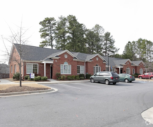


This Property Is For Sale
NEARBY LISTINGS FOR SALE OR LEASE
Property Detail
2255 Sewell Mill Rd
16-0988-0-108-0
Sewell Mill Enclave
Officecondo
Cobb
X
Georgia
13067C0126H
130
2025
0.05 AC
2025
East Cobb
030510
Atlanta
3,918 SF
Atlanta-Sandy Springs-Roswell, GA
DEMOGRAPHICS near 2255 Sewell Mill Rd
1 Mile
3 Mile
5 Mile
2024 Total Population
8,455
72,863
195,152
2029 Population
8,497
73,828
198,095
Pop Growth 2024-2029
+ 0.50%
+ 1.32%
+ 1.51%
Average Age
40
40
39
2024 Total Households
3,425
27,367
75,199
HH Growth 2024-2029
+ 0.41%
+ 1.30%
+ 1.52%
Median Household Inc
$89,903
$98,025
$92,222
Avg Household Size
2.40
2.50
2.50
2024 Avg HH Vehicles
2.00
2.00
2.00
Median Home Value
$449,242
$376,825
$406,471
Median Year Built
1985
1981
1982
Nearby Places
Map Layers
Map Styles
 Street
 Aerial
- Restaurants
- Banks
- Shops
- Fitness
- Groceries
PUBLIC TRANSPORTATION
AIRPORT
Hartsfield - Jackson Atlanta International
DRIVE
WALK
Distance
Hartsfield - Jackson Atlanta International
39 min
28.1 mi
Freight Ports
Georgia Ports - Savannah
DRIVE
WALK
Distance
Georgia Ports - Savannah
302 min
267.4 mi
Nearby Properties
Address
Land Use
TOTAL SIZE
Lot Size
Zoning
Address
Land Use
TOTAL SIZE
Lot Size
Zoning
452,366 SF
27.27 AC
PRD MF
Address
Land Use
TOTAL SIZE
Lot Size
Zoning
494,076 SF
33.30 AC
PRD MF
Address
Land Use
TOTAL SIZE
Lot Size
Zoning
300,105 SF
43.12 AC
RM-8
Address
Land Use
TOTAL SIZE
Lot Size
Zoning
343,570 SF
22.65 AC
PRD MF
Address
Land Use
TOTAL SIZE
Lot Size
Zoning
8,000 SF
9.57 AC
PRD MF
Address
Land Use
TOTAL SIZE
Lot Size
Zoning
284,832 SF
19.56 AC
PRD MF
Address
Land Use
TOTAL SIZE
Lot Size
Zoning
243,574 SF
40.05 AC
RM-8
Address
Land Use
TOTAL SIZE
Lot Size
Zoning
3,406 SF
23.20 AC
R20
Address
Land Use
TOTAL SIZE
Lot Size
Zoning
285,846 SF
19.21 AC
PRD MF
Address
Land Use
TOTAL SIZE
Lot Size
Zoning
228,652 SF
24.19 AC
RM-12
Address
Land Use
TOTAL SIZE
Lot Size
Zoning
509,792 SF
4.45 AC
OHR
Address
Land Use
TOTAL SIZE
Lot Size
Zoning
226,769 SF
13.40 AC
RM-16
Address
Land Use
TOTAL SIZE
Lot Size
Zoning
240,628 SF
30.90 AC
RM-8
Address
Land Use
TOTAL SIZE
Lot Size
Zoning
232,894 SF
13.88 AC
PRD MF
Address
Land Use
TOTAL SIZE
Lot Size
Zoning
198,488 SF
16.79 AC
RM-12
Address
Land Use
TOTAL SIZE
Lot Size
Zoning
200,238 SF
18.92 AC
RM-12
Address
Land Use
TOTAL SIZE
Lot Size
Zoning
254,242 SF
17.48 AC
RM-8
Address
Land Use
TOTAL SIZE
Lot Size
Zoning
431,575 SF
7.16 AC
OHR
Address
Land Use
TOTAL SIZE
Lot Size
Zoning
29,418 SF
31.68 AC
Address
Land Use
TOTAL SIZE
Lot Size
Zoning
325,227 SF
22.42 AC
RM-12
Address
Land Use
TOTAL SIZE
Lot Size
Zoning
146,089 SF
10.29 AC
PRD MF
Address
Land Use
TOTAL SIZE
Lot Size
Zoning
175,128 SF
12.21 AC
RM-12
Address
Land Use
TOTAL SIZE
Lot Size
Zoning
167,727 SF
13.40 AC
CRC
Address
Land Use
TOTAL SIZE
Lot Size
Zoning
200,134 SF
12.60 AC
RM-8
Address
Land Use
TOTAL SIZE
Lot Size
Zoning
402,202 SF
32.52 AC
HI
Address
Land Use
TOTAL SIZE
Lot Size
Zoning
182,506 SF
8.49 AC
RSL
Address
Land Use
TOTAL SIZE
Lot Size
Zoning
5 AC
PSC/NS
Address
Land Use
TOTAL SIZE
Lot Size
Zoning
126,855 SF
13.71 AC
NS
Address
Land Use
TOTAL SIZE
Lot Size
Zoning
132,868 SF
13.50 AC
RM-12
Address
Land Use
TOTAL SIZE
Lot Size
Zoning
208,355 SF
21.76 AC
CRC
The World's #1 Commercial Real Estate Marketplace
Connect with us
© 2026 CoStar Group
The information above has been obtained from sources believed reliable. While we do not doubt its accuracy we have not verified it and make no guarantee, warranty or representation about it. It is your responsibility to independently confirm its accuracy and completeness. Any projections, opinions, assumptions, or estimates used are for example only and do not represent the current or future performance of the property. The value of this transaction to you depends on tax and other factors which should be evaluated by your tax, financial, and legal advisors. You and your advisors should conduct a careful, independent investigation of the property to determine to your satisfaction the suitability of the property for your needs.