Property Record
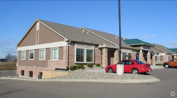
2293 Highway 55, Saint Paul, MN 55120

NEARBY LISTINGS FOR SALE OR LEASE
Property Detail
2293 Highway 55
27-83500-05-101
Waters Drive Business Park
Commercialnec
1 1 CIC #541 WATERS DRIVE BUSINESS PARK UNIT 101 & INT ATTRIBUTABLE TO COMMON AREA KNOWN AS OUTLOTS A & B WATERS DRIVE BUSINESS PARK
X
Dakota
27053C0500F
Minnesota
2024
101
2024
Burnsville/Eagan/Apple Vy
060605
Minneapolis/St Paul
1,380 SF
Minneapolis-St. Paul-Bloomington, MN-WI
DEMOGRAPHICS near 2293 Highway 55
1 Mile
3 Mile
5 Mile
2024 Total Population
1,027
36,028
195,568
2029 Population
1,060
36,266
195,187
Pop Growth 2024-2029
+ 3.21%
+ 0.66%
(0.19%)
Average Age
43
42
40
2024 Total Households
527
16,344
83,885
HH Growth 2024-2029
+ 3.23%
+ 0.49%
(0.29%)
Median Household Inc
$57,753
$78,927
$83,443
Avg Household Size
1.90
2.10
2.20
2024 Avg HH Vehicles
2.00
2.00
2.00
Median Home Value
$711,409
$384,546
$347,510
Median Year Built
1989
1981
1967
Nearby Places
Map Layers
Map Styles
 Street
 Aerial
- Restaurants
- Banks
- Shops
- Fitness
- Groceries
PUBLIC TRANSPORTATION
AIRPORT
Minneapolis-St Paul International/Wold-Chamberlain
DRIVE
WALK
Distance
Minneapolis-St Paul International/Wold-Chamberlain
8 min
4.8 mi
Freight Ports
Port of Shreveport
DRIVE
WALK
Distance
Port of Shreveport
1 min
865.2 mi
SALE & LEASE HISTORY
LISTING DATE
SALE/LEASE

Oct 18, 2024
For Lease
Jun 04, 2025
For Sale
Nearby Properties
Address
Land Use
TOTAL SIZE
Lot Size
Zoning
Address
Land Use
TOTAL SIZE
Lot Size
Zoning
479,742 SF
11.35 AC
Address
Land Use
TOTAL SIZE
Lot Size
Zoning
466,503 SF
28.74 AC
Address
Land Use
TOTAL SIZE
Lot Size
Zoning
657,358 SF
17.12 AC
Address
Land Use
TOTAL SIZE
Lot Size
Zoning
264,370 SF
36.39 AC
Address
Land Use
TOTAL SIZE
Lot Size
Zoning
173.22 AC
Address
Land Use
TOTAL SIZE
Lot Size
Zoning
247,470 SF
2.21 AC
Address
Land Use
TOTAL SIZE
Lot Size
Zoning
291,589 SF
6.77 AC
Address
Land Use
TOTAL SIZE
Lot Size
Zoning
246,636 SF
7.20 AC
Address
Land Use
TOTAL SIZE
Lot Size
Zoning
233,578 SF
9.56 AC
Address
Land Use
TOTAL SIZE
Lot Size
Zoning
223,583 SF
5.32 AC
Address
Land Use
TOTAL SIZE
Lot Size
Zoning
381,158 SF
11.86 AC
Address
Land Use
TOTAL SIZE
Lot Size
Zoning
317,235 SF
32.38 AC
Address
Land Use
TOTAL SIZE
Lot Size
Zoning
378,880 SF
3.42 AC
Address
Land Use
TOTAL SIZE
Lot Size
Zoning
206,818 SF
2.84 AC
Address
Land Use
TOTAL SIZE
Lot Size
Zoning
300,000 SF
18.44 AC
Address
Land Use
TOTAL SIZE
Lot Size
Zoning
314,237 SF
10.63 AC
Address
Land Use
TOTAL SIZE
Lot Size
Zoning
47,397 SF
6.78 AC
Address
Land Use
TOTAL SIZE
Lot Size
Zoning
437,524 SF
6.11 AC
Address
Land Use
TOTAL SIZE
Lot Size
Zoning
233,588 SF
2.35 AC
Address
Land Use
TOTAL SIZE
Lot Size
Zoning
170,292 SF
2.08 AC
Address
Land Use
TOTAL SIZE
Lot Size
Zoning
Address
Land Use
TOTAL SIZE
Lot Size
Zoning
34,152 SF
6.11 AC
Address
Land Use
TOTAL SIZE
Lot Size
Zoning
26,838 SF
1.30 AC
Address
Land Use
TOTAL SIZE
Lot Size
Zoning
110,979 SF
9.65 AC
Address
Land Use
TOTAL SIZE
Lot Size
Zoning
44,672 SF
63.51 AC
Address
Land Use
TOTAL SIZE
Lot Size
Zoning
16,075 SF
177.89 AC
Address
Land Use
TOTAL SIZE
Lot Size
Zoning
305,011 SF
8.61 AC
Address
Land Use
TOTAL SIZE
Lot Size
Zoning
278,320 SF
31.12 AC
Address
Land Use
TOTAL SIZE
Lot Size
Zoning
159,341 SF
2.82 AC
Address
Land Use
TOTAL SIZE
Lot Size
Zoning
541,075 SF
88.93 AC
The World's #1 Commercial Real Estate Marketplace
Connect with us
© 2026 CoStar Group
The information above has been obtained from sources believed reliable. While we do not doubt its accuracy we have not verified it and make no guarantee, warranty or representation about it. It is your responsibility to independently confirm its accuracy and completeness. Any projections, opinions, assumptions, or estimates used are for example only and do not represent the current or future performance of the property. The value of this transaction to you depends on tax and other factors which should be evaluated by your tax, financial, and legal advisors. You and your advisors should conduct a careful, independent investigation of the property to determine to your satisfaction the suitability of the property for your needs.