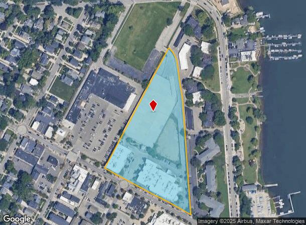
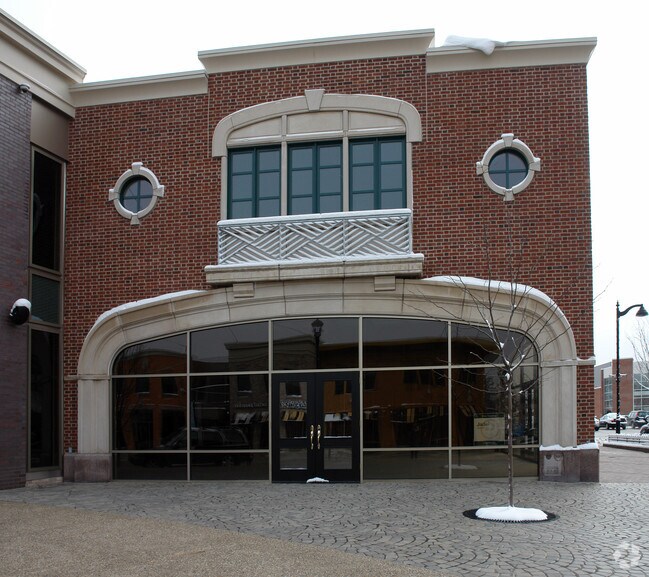
Property Record
2255 Wealthy St Se, Grand Rapids, MI 49506

NEARBY LISTINGS FOR SALE OR LEASE
Property Detail
2255 Wealthy St Se
41-14-33-276-032
Ft To Beg Boynton & Judds Lake Add
Commercialnec
PART OF LOTS 17 18 19 20 25 & PART OF VACATED PORTION OF BARNARD ST DESC AS COM 17.13 FT S 59D 59M E ALONG SLY LINE OF SD LOT
X
Kent
26081C0428D
Michigan
2024
5.51 AC
2025
Central Grand Rapids
012400
West Michigan
159,721 SF
Grand Rapids-Wyoming-Kentwood, MI
DEMOGRAPHICS near 2255 Wealthy St Se
1 Mile
3 Mile
5 Mile
2024 Total Population
10,660
112,740
251,357
2029 Population
10,773
113,308
252,395
Pop Growth 2024-2029
+ 1.06%
+ 0.50%
+ 0.41%
Average Age
39
37
37
2024 Total Households
3,784
44,831
98,640
HH Growth 2024-2029
+ 1.11%
+ 0.52%
+ 0.49%
Median Household Inc
$136,281
$66,763
$63,322
Avg Household Size
2.80
2.30
2.40
2024 Avg HH Vehicles
2.00
2.00
2.00
Median Home Value
$430,229
$250,860
$224,219
Median Year Built
1951
1954
1958
Nearby Places
Map Layers
Map Styles
 Street
 Aerial
- Restaurants
- Banks
- Shops
- Fitness
- Groceries
PUBLIC TRANSPORTATION
COMMUTER RAIL
Grand Rapids Vernon J. Ehlers Station (Pere Marquette - Amtrak)
DRIVE
WALK
Distance
Grand Rapids Vernon J. Ehlers Station (Pere Marquette - Amtrak)
9 min
4.3 mi
AIRPORT
Gerald R Ford International
DRIVE
WALK
Distance
Gerald R Ford International
20 min
9.9 mi
Freight Ports
Port Milwaukee
DRIVE
WALK
Distance
Port Milwaukee
312 min
265.6 mi
Nearby Properties
Address
Land Use
TOTAL SIZE
Lot Size
Zoning
Address
Land Use
TOTAL SIZE
Lot Size
Zoning
563,998 SF
31.75 AC
C3
Address
Land Use
TOTAL SIZE
Lot Size
Zoning
126,805 SF
9.36 AC
C4
Address
Land Use
TOTAL SIZE
Lot Size
Zoning
151,708 SF
7.22 AC
C4
Address
Land Use
TOTAL SIZE
Lot Size
Zoning
250,170 SF
16.13 AC
R-1
Address
Land Use
TOTAL SIZE
Lot Size
Zoning
211,760 SF
TN-CC
Address
Land Use
TOTAL SIZE
Lot Size
Zoning
341,808 SF
27.73 AC
HC-PUD
Address
Land Use
TOTAL SIZE
Lot Size
Zoning
491,288 SF
2.79 AC
SD-PRD
Address
Land Use
TOTAL SIZE
Lot Size
Zoning
164,591 SF
1.28 AC
TN-CC
Address
Land Use
TOTAL SIZE
Lot Size
Zoning
194,153 SF
15.84 AC
MCN-C
Address
Land Use
TOTAL SIZE
Lot Size
Zoning
22.46 AC
MON-MDR
Address
Land Use
TOTAL SIZE
Lot Size
Zoning
19.40 AC
MON-MDR
Address
Land Use
TOTAL SIZE
Lot Size
Zoning
88,327 SF
2.74 AC
TN-CC
Address
Land Use
TOTAL SIZE
Lot Size
Zoning
138,278 SF
35.63 AC
R-1
Address
Land Use
TOTAL SIZE
Lot Size
Zoning
15.94 AC
MON-MDR
Address
Land Use
TOTAL SIZE
Lot Size
Zoning
109,482 SF
1.35 AC
SD-PRD
Address
Land Use
TOTAL SIZE
Lot Size
Zoning
97,263 SF
19.37 AC
MON-MDR
Address
Land Use
TOTAL SIZE
Lot Size
Zoning
269,990 SF
1.28 AC
TN-CC
Address
Land Use
TOTAL SIZE
Lot Size
Zoning
269,990 SF
1.28 AC
TN-CC
Address
Land Use
TOTAL SIZE
Lot Size
Zoning
13.71 AC
MCN-LDR
Address
Land Use
TOTAL SIZE
Lot Size
Zoning
16.91 AC
MON-MDR
Address
Land Use
TOTAL SIZE
Lot Size
Zoning
154,643 SF
10.96 AC
O-PUD
Address
Land Use
TOTAL SIZE
Lot Size
Zoning
183,583 SF
9.12 AC
R-1
Address
Land Use
TOTAL SIZE
Lot Size
Zoning
17,671 SF
15.18 AC
MON-MDR
Address
Land Use
TOTAL SIZE
Lot Size
Zoning
158,883 SF
16.53 AC
MCN-LDR
Address
Land Use
TOTAL SIZE
Lot Size
Zoning
209,417 SF
19.51 AC
C4
Address
Land Use
TOTAL SIZE
Lot Size
Zoning
225,504 SF
0.50 AC
TN-CC
Address
Land Use
TOTAL SIZE
Lot Size
Zoning
348,367 SF
12.15 AC
SD-IT
Address
Land Use
TOTAL SIZE
Lot Size
Zoning
21.10 AC
MON-MDR
Address
Land Use
TOTAL SIZE
Lot Size
Zoning
18.86 AC
MON-MDR
The World's #1 Commercial Real Estate Marketplace
Connect with us
© 2026 CoStar Group
The information above has been obtained from sources believed reliable. While we do not doubt its accuracy we have not verified it and make no guarantee, warranty or representation about it. It is your responsibility to independently confirm its accuracy and completeness. Any projections, opinions, assumptions, or estimates used are for example only and do not represent the current or future performance of the property. The value of this transaction to you depends on tax and other factors which should be evaluated by your tax, financial, and legal advisors. You and your advisors should conduct a careful, independent investigation of the property to determine to your satisfaction the suitability of the property for your needs.