Property Record
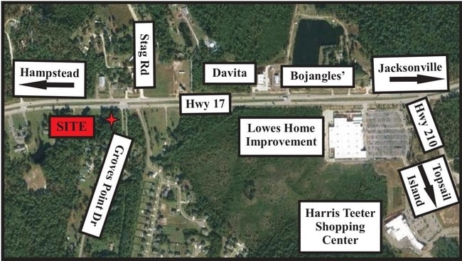
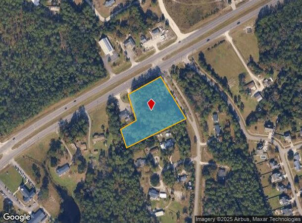
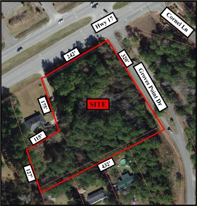
Us Highway 17 S, Hampstead, NC 28443
This Property Is For Sale
NEARBY LISTINGS FOR SALE OR LEASE
Property Detail
Us Highway 17 S
4215-67-9491-0000
2.50 AC CORNER US HWY 17 & GROVES PT
Vacantlandnec
Pender
X
North Carolina
3720421500J
2.50 AC
2024
East Pender County
2024
Wilmington
920201
Wilmington, NC
DEMOGRAPHICS near Us Highway 17 S
1 Mile
3 Mile
5 Mile
2024 Total Population
2,557
9,685
21,616
2029 Population
3,181
11,914
26,207
Pop Growth 2024-2029
+ 24.40%
+ 23.01%
+ 21.24%
Average Age
42
41
41
2024 Total Households
958
3,598
8,396
HH Growth 2024-2029
+ 24.63%
+ 23.29%
+ 21.65%
Median Household Inc
$72,515
$71,955
$72,094
Avg Household Size
2.60
2.60
2.50
2024 Avg HH Vehicles
2.00
2.00
2.00
Median Home Value
$305,350
$287,462
$292,268
Median Year Built
2010
2002
2001
Nearby Places
- Restaurants
- Banks
- Shops
- Fitness
- Groceries
PUBLIC TRANSPORTATION
AIRPORT
Wilmington International
DRIVE
WALK
Distance
Wilmington International
41 min
26.5 mi
Albert J Ellis
DRIVE
WALK
Distance
Albert J Ellis
59 min
37.3 mi
Freight Ports
Port of Wilmington
DRIVE
WALK
Distance
Port of Wilmington
48 min
28.4 mi
Nearby Properties
Address
Land Use
TOTAL SIZE
Lot Size
Zoning
Address
Land Use
TOTAL SIZE
Lot Size
Zoning
252,960 SF
32.21 AC
SEEMAP
Address
Land Use
TOTAL SIZE
Lot Size
Zoning
196,268 SF
1 AC
RP
Address
Land Use
TOTAL SIZE
Lot Size
Zoning
138,676 SF
32.99 AC
SEEMAP
Address
Land Use
TOTAL SIZE
Lot Size
Zoning
64,031 SF
9.34 AC
SEEMAP
Address
Land Use
TOTAL SIZE
Lot Size
Zoning
42,092 SF
6.23 AC
SEEMAP
Address
Land Use
TOTAL SIZE
Lot Size
Zoning
13,836 SF
2.37 AC
SEEMAP
Address
Land Use
TOTAL SIZE
Lot Size
Zoning
46,080 SF
7.41 AC
Address
Land Use
TOTAL SIZE
Lot Size
Zoning
146.90 AC
SEEMAP
Address
Land Use
TOTAL SIZE
Lot Size
Zoning
4,700 SF
13 AC
FA
Address
Land Use
TOTAL SIZE
Lot Size
Zoning
6,500 SF
34.41 AC
SEEMAP
Address
Land Use
TOTAL SIZE
Lot Size
Zoning
12.21 AC
SEEMAP
Address
Land Use
TOTAL SIZE
Lot Size
Zoning
16.98 AC
SEEMAP
Address
Land Use
TOTAL SIZE
Lot Size
Zoning
7,828 SF
2.89 AC
SEEMAP
Address
Land Use
TOTAL SIZE
Lot Size
Zoning
11,534 SF
2.50 AC
SEEMAP
Address
Land Use
TOTAL SIZE
Lot Size
Zoning
19,000 SF
9.39 AC
PD
Address
Land Use
TOTAL SIZE
Lot Size
Zoning
1,420 SF
23.59 AC
PD
Address
Land Use
TOTAL SIZE
Lot Size
Zoning
13,482 SF
3.99 AC
SEEMAP
Address
Land Use
TOTAL SIZE
Lot Size
Zoning
9,237 SF
2.17 AC
SEEMAP
Address
Land Use
TOTAL SIZE
Lot Size
Zoning
53.74 AC
SEEMAP
Address
Land Use
TOTAL SIZE
Lot Size
Zoning
2,400 SF
17.98 AC
SEEMAP
Address
Land Use
TOTAL SIZE
Lot Size
Zoning
55.27 AC
SEEMAP
Address
Land Use
TOTAL SIZE
Lot Size
Zoning
4,190 SF
2.65 AC
SEEMAP
Address
Land Use
TOTAL SIZE
Lot Size
Zoning
6,850 SF
8.09 AC
SEEMAP
Address
Land Use
TOTAL SIZE
Lot Size
Zoning
12,745 SF
1.38 AC
Address
Land Use
TOTAL SIZE
Lot Size
Zoning
35,700 SF
5.71 AC
GB
Address
Land Use
TOTAL SIZE
Lot Size
Zoning
2,912 SF
4 AC
R20C
Address
Land Use
TOTAL SIZE
Lot Size
Zoning
17,500 SF
5.94 AC
RT
Address
Land Use
TOTAL SIZE
Lot Size
Zoning
12,000 SF
1.52 AC
SEEMAP
Address
Land Use
TOTAL SIZE
Lot Size
Zoning
8,892 SF
1.22 AC
Address
Land Use
TOTAL SIZE
Lot Size
Zoning
22,324 SF
4.72 AC
PD
The World's #1 Commercial Real Estate Marketplace
Connect with us
© 2025 CoStar Group
The information above has been obtained from sources believed reliable. While we do not doubt its accuracy we have not verified it and make no guarantee, warranty or representation about it. It is your responsibility to independently confirm its accuracy and completeness. Any projections, opinions, assumptions, or estimates used are for example only and do not represent the current or future performance of the property. The value of this transaction to you depends on tax and other factors which should be evaluated by your tax, financial, and legal advisors. You and your advisors should conduct a careful, independent investigation of the property to determine to your satisfaction the suitability of the property for your needs.