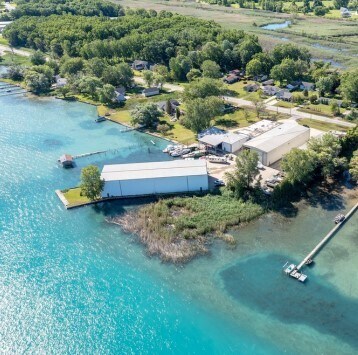
Property Record
2256 N Channel Dr, Harsens Island, MI 48028

NEARBY LISTINGS FOR SALE OR LEASE
Property Detail
2256 N Channel Dr
Detroit-Warren-Dearborn, MI
Assessors
14-631-0069-000
LOT 97 & PART LOT 98 ASSESSORS PLAT NO 1 OF HARSENS ISLAND & LOTS 1 & 2 JACOB HARSEN FARM SUBDIVISION AND INCLUDING LANDS TO CHANNEL BANK OF THE NORTH CHANNEL AND THAT PART OF LOT 2 LYING SOUTH OF EXTENDED ROW LINE OF M-154 DESC AS: BEG S 44D 12M 30S
Warehouse
St. Clair
AE
Michigan
26147C0577E
97-98
2025
1.77 AC
2025
St Clair & Lapeer Counties
648000
Detroit
37,823 SF
DEMOGRAPHICS near 2256 N Channel Dr
1 Mile
3 Mile
5 Mile
2024 Total Population
1,546
11,248
15,186
2029 Population
1,577
11,421
15,452
Pop Growth 2024-2029
+ 2.01%
+ 1.54%
+ 1.75%
Average Age
47
47
48
2024 Total Households
701
5,086
6,895
HH Growth 2024-2029
+ 2.28%
+ 1.53%
+ 1.86%
Median Household Inc
$66,572
$59,010
$61,877
Avg Household Size
2.20
2.20
2.20
2024 Avg HH Vehicles
2.00
2.00
2.00
Median Home Value
$207,643
$206,829
$233,757
Median Year Built
1975
1971
1972
Nearby Places
Map Layers
Map Styles
 Street
 Aerial
- Restaurants
- Banks
- Shops
- Fitness
- Groceries
Nearby Properties
Address
Land Use
TOTAL SIZE
Lot Size
Zoning
Address
Land Use
TOTAL SIZE
Lot Size
Zoning
232,654 SF
24.28 AC
C-3
Address
Land Use
TOTAL SIZE
Lot Size
Zoning
69,306 SF
13.25 AC
C-3
Address
Land Use
TOTAL SIZE
Lot Size
Zoning
Address
Land Use
TOTAL SIZE
Lot Size
Zoning
Address
Land Use
TOTAL SIZE
Lot Size
Zoning
1,904 SF
98.63 AC
MHP
Address
Land Use
TOTAL SIZE
Lot Size
Zoning
48,036 SF
4.07 AC
CBD
Address
Land Use
TOTAL SIZE
Lot Size
Zoning
54,976 SF
6.83 AC
R-3
Address
Land Use
TOTAL SIZE
Lot Size
Zoning
9.71 AC
R-1
Address
Land Use
TOTAL SIZE
Lot Size
Zoning
68,193 SF
3.38 AC
R-2
Address
Land Use
TOTAL SIZE
Lot Size
Zoning
9,553 SF
0.55 AC
R-3
Address
Land Use
TOTAL SIZE
Lot Size
Zoning
492 AC
RS-1
Address
Land Use
TOTAL SIZE
Lot Size
Zoning
11,052 SF
1.73 AC
CBD
Address
Land Use
TOTAL SIZE
Lot Size
Zoning
48,646 SF
2.95 AC
C-3
Address
Land Use
TOTAL SIZE
Lot Size
Zoning
12,936 SF
1.47 AC
CBD
Address
Land Use
TOTAL SIZE
Lot Size
Zoning
4,023 SF
1.50 AC
GB
Address
Land Use
TOTAL SIZE
Lot Size
Zoning
53,430 SF
11.67 AC
C-3
Address
Land Use
TOTAL SIZE
Lot Size
Zoning
19,140 SF
2.72 AC
R-3
Address
Land Use
TOTAL SIZE
Lot Size
Zoning
42,914 SF
6.56 AC
C-3
Address
Land Use
TOTAL SIZE
Lot Size
Zoning
18,069 SF
2.73 AC
R-3
Address
Land Use
TOTAL SIZE
Lot Size
Zoning
5,160 SF
7.74 AC
RS-1
Address
Land Use
TOTAL SIZE
Lot Size
Zoning
7,100 SF
1.23 AC
CBD
Address
Land Use
TOTAL SIZE
Lot Size
Zoning
3,915 SF
8.29 AC
C-3
Address
Land Use
TOTAL SIZE
Lot Size
Zoning
3,216 SF
0.71 AC
CBD
Address
Land Use
TOTAL SIZE
Lot Size
Zoning
17,589 SF
3.27 AC
R-3
Address
Land Use
TOTAL SIZE
Lot Size
Zoning
4,556 SF
1.79 AC
GB
Address
Land Use
TOTAL SIZE
Lot Size
Zoning
10,112 SF
0.46 AC
RM
Address
Land Use
TOTAL SIZE
Lot Size
Zoning
4,088 SF
49.56 AC
R-1
Address
Land Use
TOTAL SIZE
Lot Size
Zoning
286.71 AC
RS-1
Address
Land Use
TOTAL SIZE
Lot Size
Zoning
47,032 SF
3.78 AC
I-1
The World's #1 Commercial Real Estate Marketplace
Connect with us
© 2026 CoStar Group
The information above has been obtained from sources believed reliable. While we do not doubt its accuracy we have not verified it and make no guarantee, warranty or representation about it. It is your responsibility to independently confirm its accuracy and completeness. Any projections, opinions, assumptions, or estimates used are for example only and do not represent the current or future performance of the property. The value of this transaction to you depends on tax and other factors which should be evaluated by your tax, financial, and legal advisors. You and your advisors should conduct a careful, independent investigation of the property to determine to your satisfaction the suitability of the property for your needs.